Visited on: Wednesday 5 – Monday 10 September 2018
Day 5: Fisherman’s Wharf, Chinatown and Telegraph Hill
I had been staying in San Francisco for four nights. So far, the weather had mostly been grey and cold, and there was no change on the Thursday morning.
I had booked a different hotel for the second half of my trip. Unable to check into the second hotel until the afternoon, I left my suitcase with reception and went for a walk around the neighbourhood. First of all, I walked down to the Castro district, which is San Francisco’s main lesbian and gay village, although there were few obvious signs of this fact apart from the prominent rainbow flags draped from the street lights. The area was busy with morning rush-hour commuters hurrying towards the metro station at the junction of Market and Castro Streets.
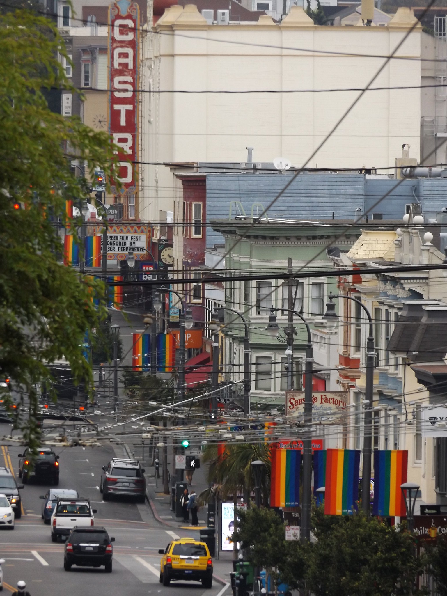
South of this busy junction, the main shopping strip of Castro Street descends into a valley before rising up a steep hill, flanked by wooden Victorian houses. The street is dominated by the Castro Theatre, built in 1922 as a cinema, with its Baroque-style façade and huge red neon sign.
The Castro area began to develop as a lesbian and gay neighbourhood in the 1960s, at the same time as the “flower power” movement in nearby Haight-Ashbury. Before that, for much of the late 19th and early 20th centuries, it was home to San Francisco’s Finnish community. At that time, the Russian Empire had settlements in California and Hawaii, as well as possessing the whole of present-day Alaska, and large numbers of Finnish seamen were employed in Russia’s naval and merchant shipping operations along the north-west coast of America.
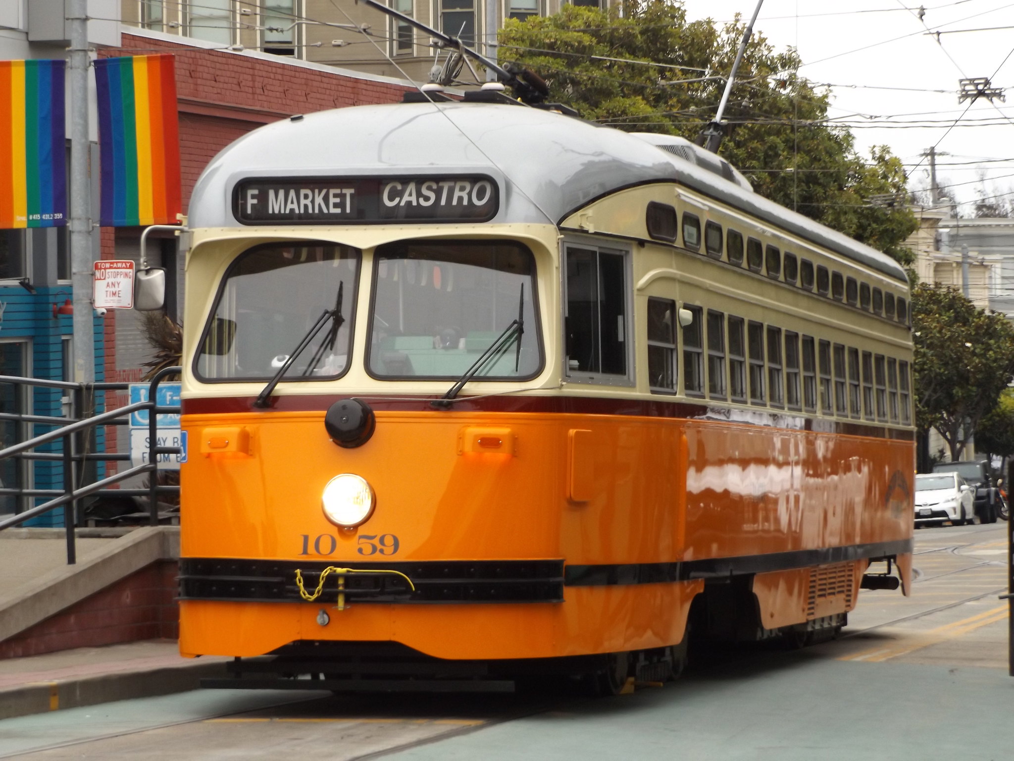
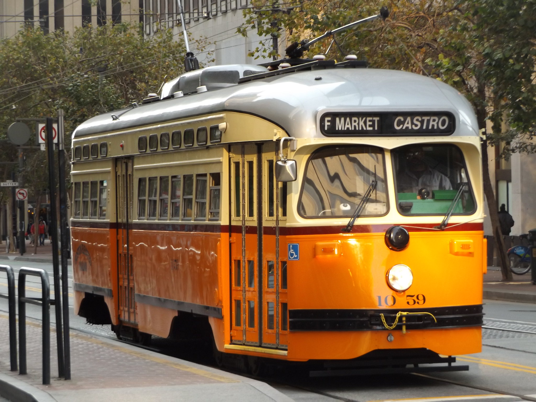
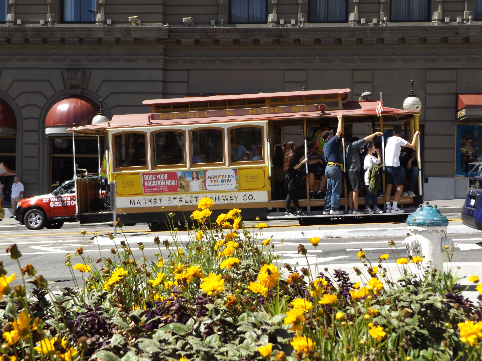
At the junction with Market Street, a bright orange, old-fashioned tram was waiting at its terminus. Known in San Francisco as “historic streetcars”, the trams have an interesting origin. When plans for the construction of the BART service were drawn up in 1962, it was decided that the streetcars then operating along Market Street should be rerouted underground to provide a faster service. Keen to retain a street-level transport service along Market Street, transport heritage enthusiasts came up with the idea of a historic streetcar service. Historic streetcars finally began operating along Market Street on summer weekends in 1981 and 1982, before the contemporary streetcars had moved underground.
From 1982 to 1984, a refurbishment programme was carried out on San Francisco’s famous cable car system. This led to calls for the historic streetcar service to be extended to provide an alternative form of heritage transport for visitors to the city to enjoy while the cable car service was suspended. Trolley festivals were organised each summer from 1983 until 1987, and their popularity with both San Franciscans and visitors led to calls for the historic streetcar service to operate on a full-time basis along the Embarcadero and Market Street. Construction work for the permanent service along Market Street took place in 1988-95, and work on the Embarcadero section started following the demolition of the freeway after the 1989 Loma Prieta earthquake. Trams operating on Line F run from Fisherman’s Wharf at the northern end of the peninsula via the Ferry Building and Market Street to the Castro in the south-west. The less frequent Line E operates from Fisherman’s Wharf to the Ferry Building, before continuing south along the Embarcadero to the Caltrain station. The trams are equipped with modern fareboxes and at each stop there is a ramp and wheelchair lift, as well as real-time departure information.
The streetcar I seemed to see most often was no. 1059, built in 1948 for the Philadelphia Transportation Company, although now painted in the orange, cream and silver livery of the Boston Elevated Tramway.
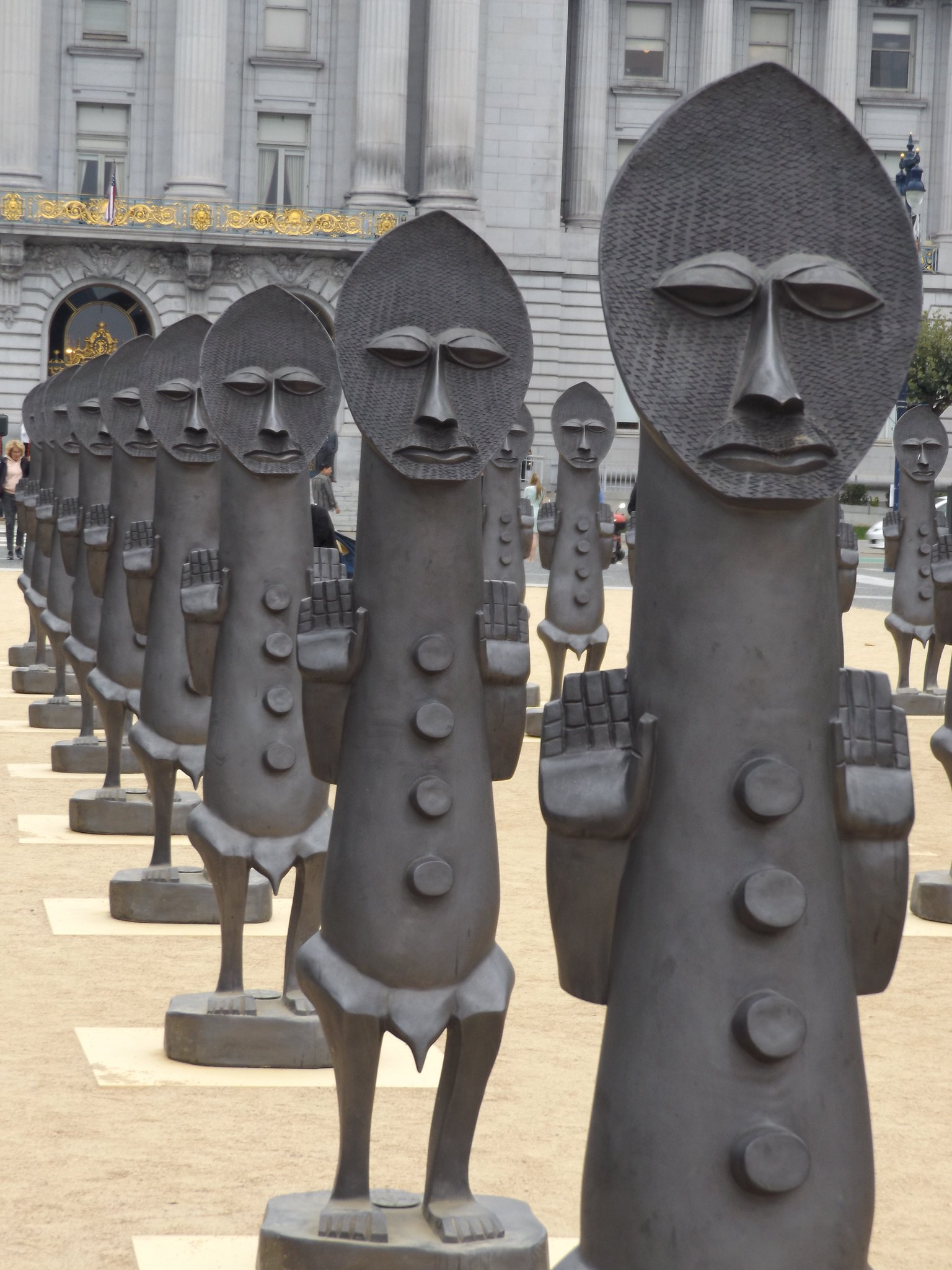
From the Castro, I walked along Market Street towards Downtown. The weather was still grey, although there were occasional hints of a brightening sky. In Civic Center Plaza, there was a striking art installation by British sculptor Zak Ové, “The Invisible Man and the Masque of Blackness”. It consisted of 40 identical 2-metre high Nubian figures arranged in serried ranks against the backdrop of City Hall. It was only a temporary fixture in the Plaza, having travelled across the Atlantic from the Yorkshire Sculpture Park in Wakefield a few months earlier, and was attracting a lot of interest.
After stopping at the Davies Symphony Hall box office to buy a ticket to Saturday night’s performance by the San Francisco Symphony Orchestra, I made my way slowly back to the hotel to collect my suitcase.
Dragging my luggage down to the tram stop opposite Safeway, I boarded one of the historic streetcars to Fisherman’s Wharf, where my second hotel was located. On the way, the grey clouds finally gave way to blue sky and sunshine. The weather usually turns sunnier and warmer at about this time each September after the foggy summer months.
When I arrived at the San Remo Hotel, my room wasn’t ready, so I left my suitcase with reception and went out to explore the surrounding area. Fisherman’s Wharf was a noticeably livelier and more touristy area than anywhere I had visited so far. The retail and leisure developments along the waterfront didn’t feel entirely authentic, although there were plenty of interesting things to see and do.
Next to Pier 45, I found the Musée Mécanique, a privately-owned collection of historic slot machines and other curiosities. Amusement arcades are not really my thing, but nobody could fail to be entertained by the museum’s weird and in some cases macabre exhibits, collected over several decades by Edward Zelinsky. Entry is free, as the museum derives its income from the slot machines, most of which are still in full working order. The largest exhibit is Laffing Sal, a huge figure of a scruffily-dressed woman with rosy cheeks and a missing tooth in a big glass case. Laffing Sal and her partner Laffing Sam were mainstays of amusement halls throughout America in the 1930s and 40s; the one at the Musée Mécanique came from San Francisco’s Playland at the Beach. Somebody put some money in the slot, and Laffing Sal came to life in a creepily realistic way with her loud shrieks of laughter, shaking upper body and waving arms.

Other exhibits included a drunk man swinging from a lamp post, another drunkard holding a bottle of spirit exhorting punters to “Give Dan a drink!”, mechanical reproductions of a farm, fighting bison, an oilfield, the 1906 San Francisco earthquake and fire, and various murders.
Walking towards Pier 39, I was alerted by the sound of barking sea lions, and went over to investigate. I had heard that sea lions occasionally hauled out on the pontoons by the pier, but wasn’t expecting to see hundreds of sleeping sea lions completely covering two large pontoons, packed together in tight rows like sardines, occasionally lifting their heads to bark and tussle with each other.
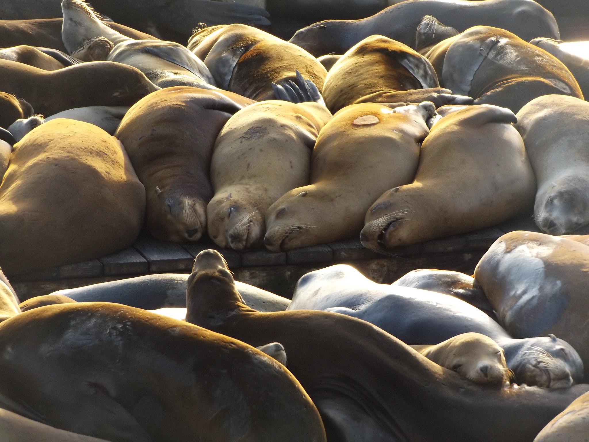
The sea lions began hauling out at K-Dock next to Pier 39 in December 1989, and by 1990, numbers had swelled to over 300, completely taking over the dock. The Bay offers a plentiful supply of food such as herring as well as protection from the sea lions’ predators. It is thought that the refurbishment of the docks after the Loma Prieta earthquake, which necessitated the removal of all boats from the area, created an opportunity for the sea lions to move in. Despite complaints from some boat owners, it was decided that the sea lions should be protected in their new home on the basis of advice from the Marine Mammal Center and recognition of the sea lions’ potential to attract tourists back to the area after the earthquake. Most of the sea lions at Pier 39 are male. Numbers fluctuate as a result of annual migrations, but it is usually possible to see a few of them there throughout the year. On the other side of Pier 39, away from the hordes of sea lions and tourists, a huge male sea lion lay snoozing peacefully on a pontoon in the sunshine, using a mooring rope tie as a chin rest.

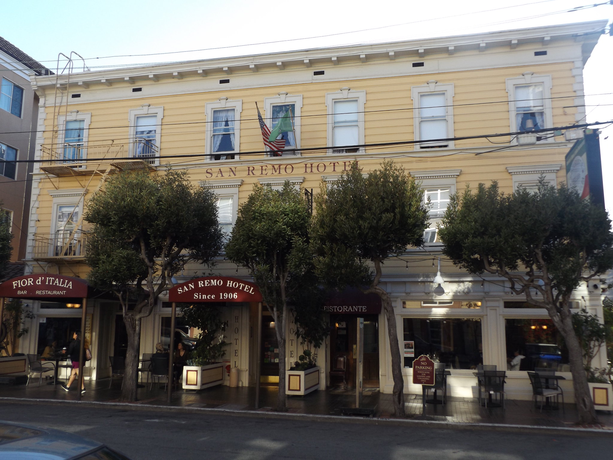
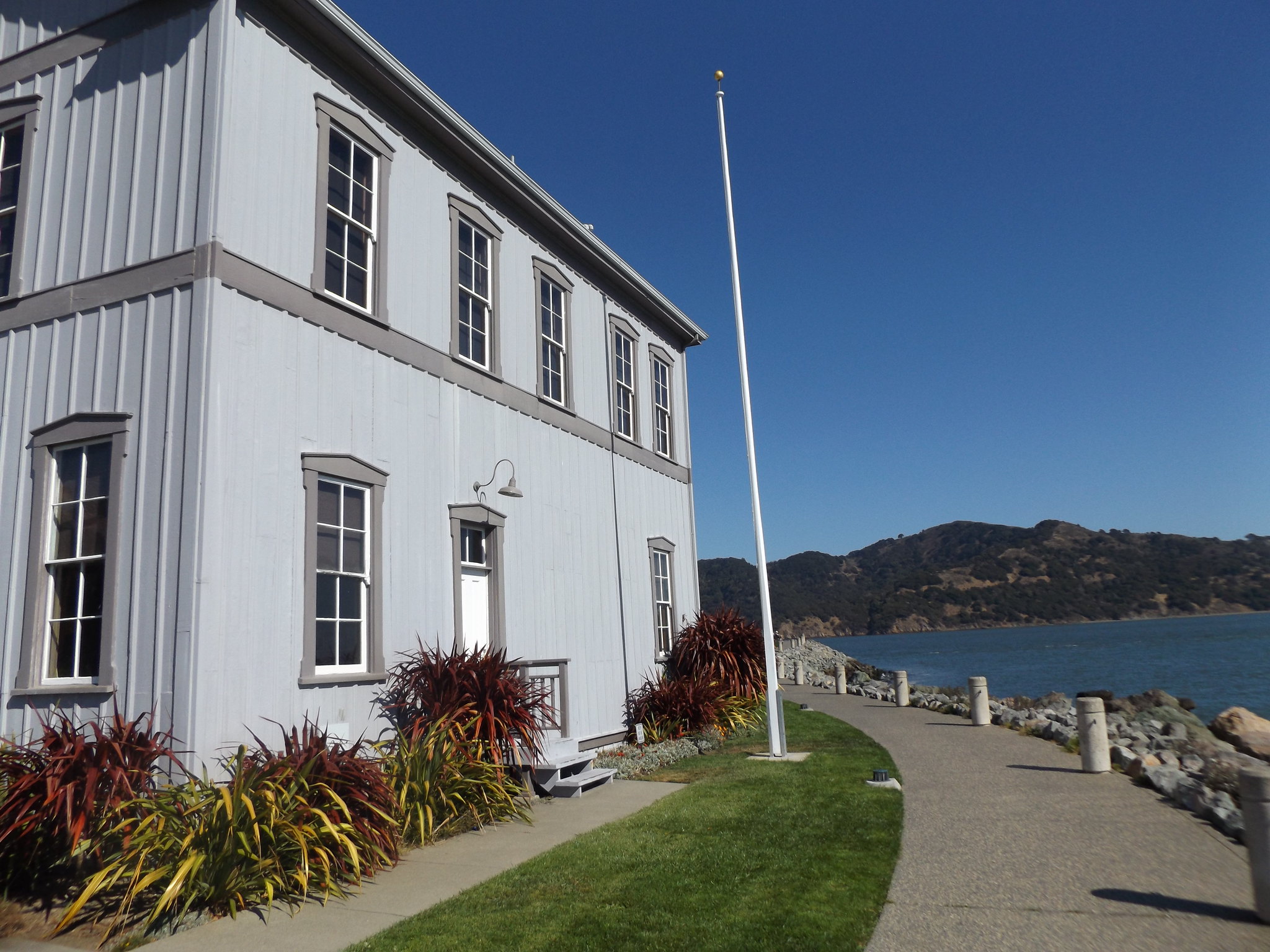
It was still early afternoon when I returned to the San Remo Hotel to check into my room. The San Remo was considerably more expensive than the previous hotel, but given its illustrious history, quirky interior décor and proximity to the main tourist areas, it was well worth the extra money. It occupies a yellow-painted wooden building in Mason Street, a few blocks south of Fisherman’s Wharf. It was built as the New California Hotel in 1906 by the founder of the Bank of America, A. P. Giannini, to house the temporary workforce brought in to rebuild the area after the terrible earthquake which struck San Francisco on 18 April 1906. Born in San José to Italian immigrant parents in 1870, Giannini had set up the Bank of Italy in San Francisco in 1904 and was instrumental in rebuilding the city after the earthquake and the devastating fire which followed it. Many of the men drafted in for the rebuilding were Italian, and the area around Fisherman’s Wharf and Telegraph Hill still has strong Italian connections today. In 1922, the hotel was renamed the San Remo, after the town near Genoa, reflecting the Genovese-style cuisine served in its restaurant. In 1970, it was acquired by Tom and Robert Field, who restored it to its original turn-of-the-century charm.
Although my room had no external window, it had a sash window opening on to a bright hallway with skylights and lush houseplants. The décor was old-fashioned, with flowery wallpaper and bed linen, and the hallways, stairwells and rooms were full of memorabilia reflecting San Francisco’s 20th century history. A bicycle hung from the wall of the main stairwell, and the corridors were adorned with framed sepia photographs of bishops and watercolours of cable cars and trams. There was a framed poster warning tourists not to visit San Francisco in the aftermath of the 1906 earthquake. Other than wi-fi, there were none of the usual concessions to modernity, such as televisions, minibars or strip lighting. The toilets and bathrooms were communal, with ornate ceramics, freestanding bathtubs and old-fashioned chain-operated toilets; the washbasins were situated in recesses off the main hallway.

With much of the afternoon still to spare, I set off in bright sunshine to explore the area. Although Fisherman’s Wharf is backed by unsightly multi-storey car parks and boxy supermarkets, the area south of Bay Street is one of the most visually striking and interesting areas of San Francisco, built on three hills: Russian Hill, Nob Hill and Telegraph Hill. The strict grid pattern of streets makes few concessions to the hilly terrain in this part of the city, and walking up and down the steep streets takes a lot of stamina. In a few places, the hillsides are so steep that the streets are blocked off to traffic, replaced by pedestrian steps. However, one of the most vertiginous streets, Lombard Street, is not blocked off at its steepest point, but instead winds its way down the hillside in a series of hairpin bends, flanked by flowerbeds planted with luxuriant hydrangeas. Traffic can only travel in one direction, downhill, and some daredevil drivers race down the hairpins at ridiculous speeds. The “world’s crookedest street” is popular with photographers and selfie-takers, and a traffic warden seems to be permanently employed to patrol the steep steps shouting at pedestrians not to walk in the roadway.
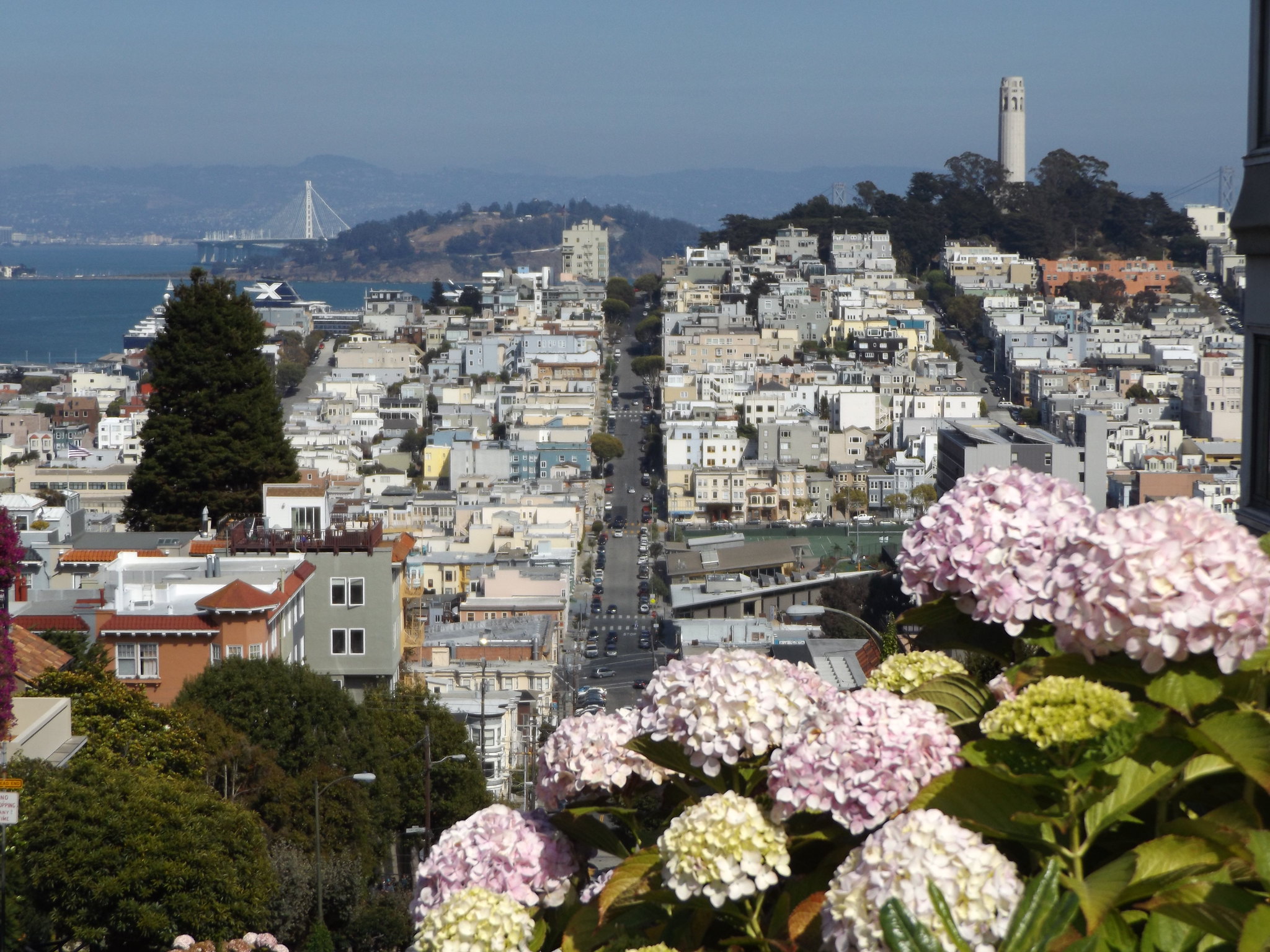
At the top of Lombard Street, I turned into Hyde Street, one of the streets along which the cable cars run. Near the top of Russian Hill, in Vallejo Street, there was a small park with squawking red-masked parakeets and spectacular views of the city’s skyscrapers, the Bay Bridge and Telegraph Hill. From here, steep steps led down to Mason Street. A few blocks to the south, the two north-south cable car routes (Powell-Mason and Powell-Hyde) converged at a road junction, on the corner of which was a prominent brick building with a large round chimney: the cable car barn and powerhouse, also housing the cable car museum (free admission).
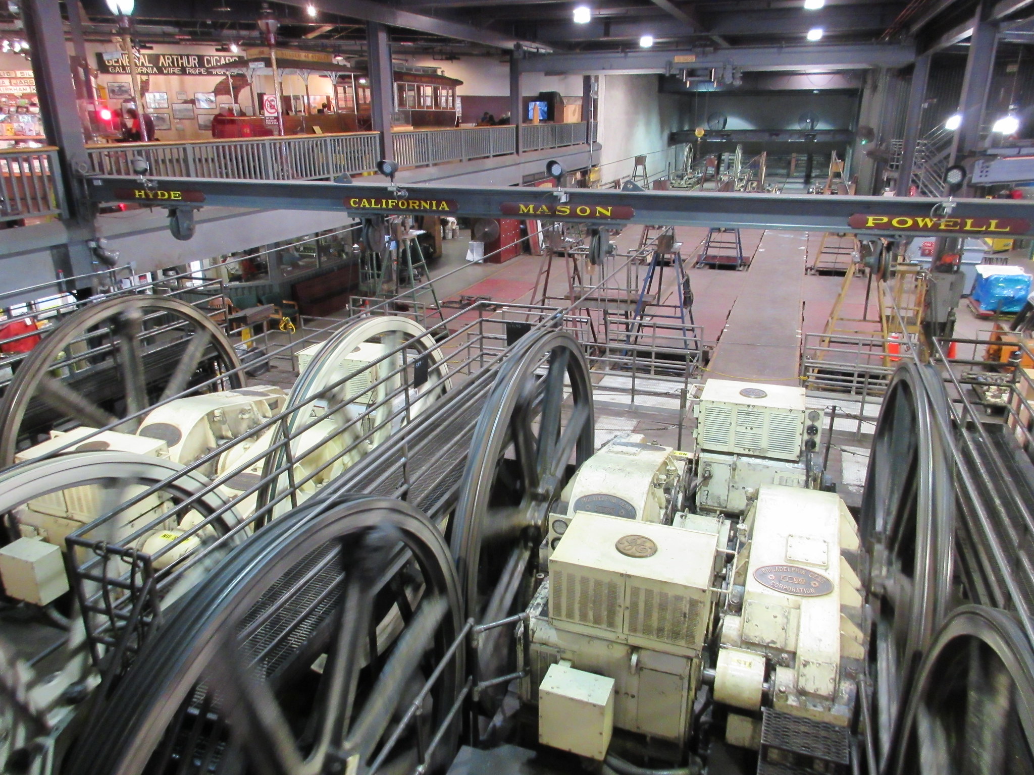
San Francisco’s unique cable car system was invented in 1869 by a London-born engineer, Andrew Smith Hallidie, and began operation in 1873. The cable cars aren’t self-propelled, but cling to moving cables under the street by means of a grip operated by the driver. The driver can vary the speed of the cable car by adjusting the tightness of the grip on the cables. The cables lie beneath a slot along the street and are turned continuously by a system of pulleys, powered from the central powerhouse. Inside the museum, the pulleys serving the four main streets on which the cable cars operate (Hyde, California, Mason and Powell) can be viewed from an observation deck. There are displays explaining the mechanics of the cable car system, the history of the different cable car companies and the extensive network of routes which once operated, and the campaign to preserve the last surviving cable car routes for future generations. Three historic cable cars from the 1870s are displayed alongside a wide range of cable car memorabilia and photographs.
Leaving the Cable Car Museum, I entered San Francisco’s vibrant Chinatown district, the oldest and largest in North America. It is the most densely populated are of the city, inhabited almost entirely by monolingual Mandarin and Cantonese speakers. After exploring the bustling streets and alleyways of Chinatown, I crossed over Columbus Avenue and climbed to the top of Telegraph Hill. Deciding not to join the long queue to go up Coit Tower, I descended the steep footpath down the eastern slope of the hill, passing between beautiful, secluded gardens with Anna’s hummingbirds darting among the flowers. A metal staircase led down the sheer cliff at the bottom of the hill to the Embarcadero, from where it was a short walk back to Fisherman’s Wharf.
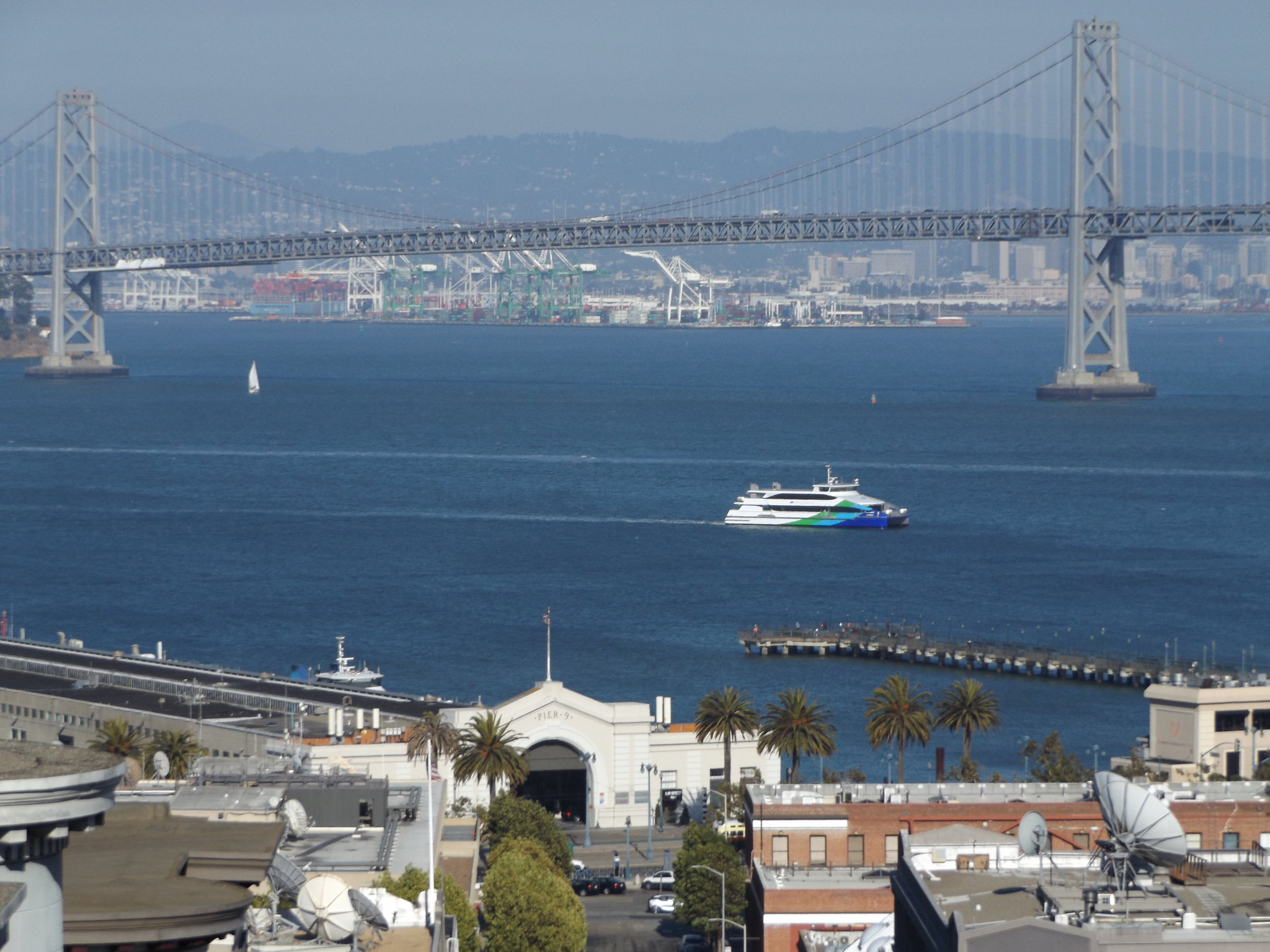
Once marred by a hideous elevated freeway, the Embarcadero is one of San Francisco’s most distinctive thoroughfares. North of the Ferry Building, a long chain of warehouses with uniform white stucco façades and huge domed gateways lines one side of the street, each warehouse bearing the odd number of the pier behind it from Pier 1 to Pier 35 (the even-numbered piers are to the south of the Ferry Building). Some of the piers are publicly accessible, giving fantastic views of the Bay Bridge, Yerba Buena Island and the Downtown skyline. Multi-coloured historic streetcars ply up and down the palm tree-lined central reservation where the freeway once stood.
I arrived back at the hotel at sunset. After a short rest, I went out to eat at Ihop, a fast food restaurant near to the hotel which served fried breakfasts and tasty pancakes.
Day 6: Sausalito, Mill Valley and Tiburon
Hiring a bicycle is a good way to explore San Francisco’s coastline, and there are plenty of bicycle hire shops around Fisherman’s Wharf, the biggest of which is Blazing Saddles. I decided to cycle over the Golden Gate Bridge to Sausalito and Tiburon, returning by ferry. Early in the morning, I went along to Blazing Saddles’ outlet next to Ihop on Powell Street, where I was shown a video explaining the route, before being given a bicycle, helmet, lock, ferry ticket and map.
It was a cold and overcast morning as I set out, taking a while to adjust to the no-frills bike with its dodgy gears. The first section of the route involved dismounting and pushing the bike through a pedestrian area next to the Maritime Museum. At Fort Mason, I stopped in the community garden for a short while to watch the birds, after which I sped along the road past the Marina District and Crissy Field to Fort Point beneath the Golden Gate Bridge. Fort Point famously appeared in Alfred Hitchcock’s movie Vertigo, in which Madeleine (Kim Novak) suddenly falls (or jumps?) into the water and is saved by Scottie (James Stewart). This iconic spot is now unfortunately marred by tall wire fencing and a no entry sign, presumably put there to deter anyone from imitating Madeleine’s actions in the movie. Fort Point itself was constructed in 1853-61 as a coastal defence against the threat of a Confederate attack during the American Civil War. In the 1930s, the fort’s survival was threatened by plans for the Golden Gate Bridge, but engineer Joseph Strauss redesigned the bridge to enable the historically important structure to be saved.
It was a steep uphill ride to the start of the Golden Gate Bridge, and I had to get off and push the bike. The viewpoint by the toll plaza at the southern end of the bridge was heaving with coach parties taking selfies. Dodging the crowds, I cycled rapidly over the bridge, not bothering to stop for photographs, as I hoped to come back to the bridge in nicer weather. It was cold and windy out on the bridge, and the tops of the towers were shrouded in mist. At the northern end of the bridge, grey clouds abruptly gave way to bright sunshine, with just a few wisps of white cloud hanging over the hills.
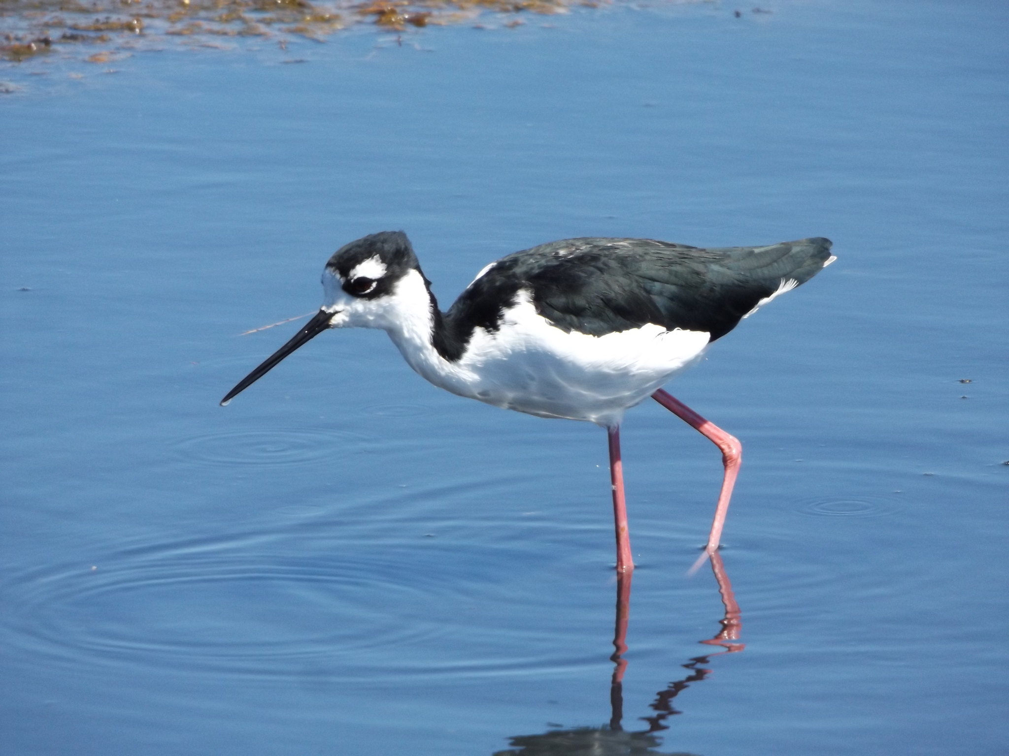
From Vista Point, I looked back at the bridge in the gloomy mist, before continuing towards Sausalito in bright sunshine. Freewheeling rapidly down Alexander Avenue into Sausalito, I stopped to take photographs by the harbour. With its fine villas and luxuriant gardens stacked up steep, wooded hillsides and a waterfront dotted with yachts, Sausalito reminded me of Dartmouth in Devon. At the northern end of town, houseboats were moored in rows along the waterfront. Leaving the road, I joined an off-road cycle path through a fantastic expanse of marshland with great white egrets and a beautiful black-necked stilt.
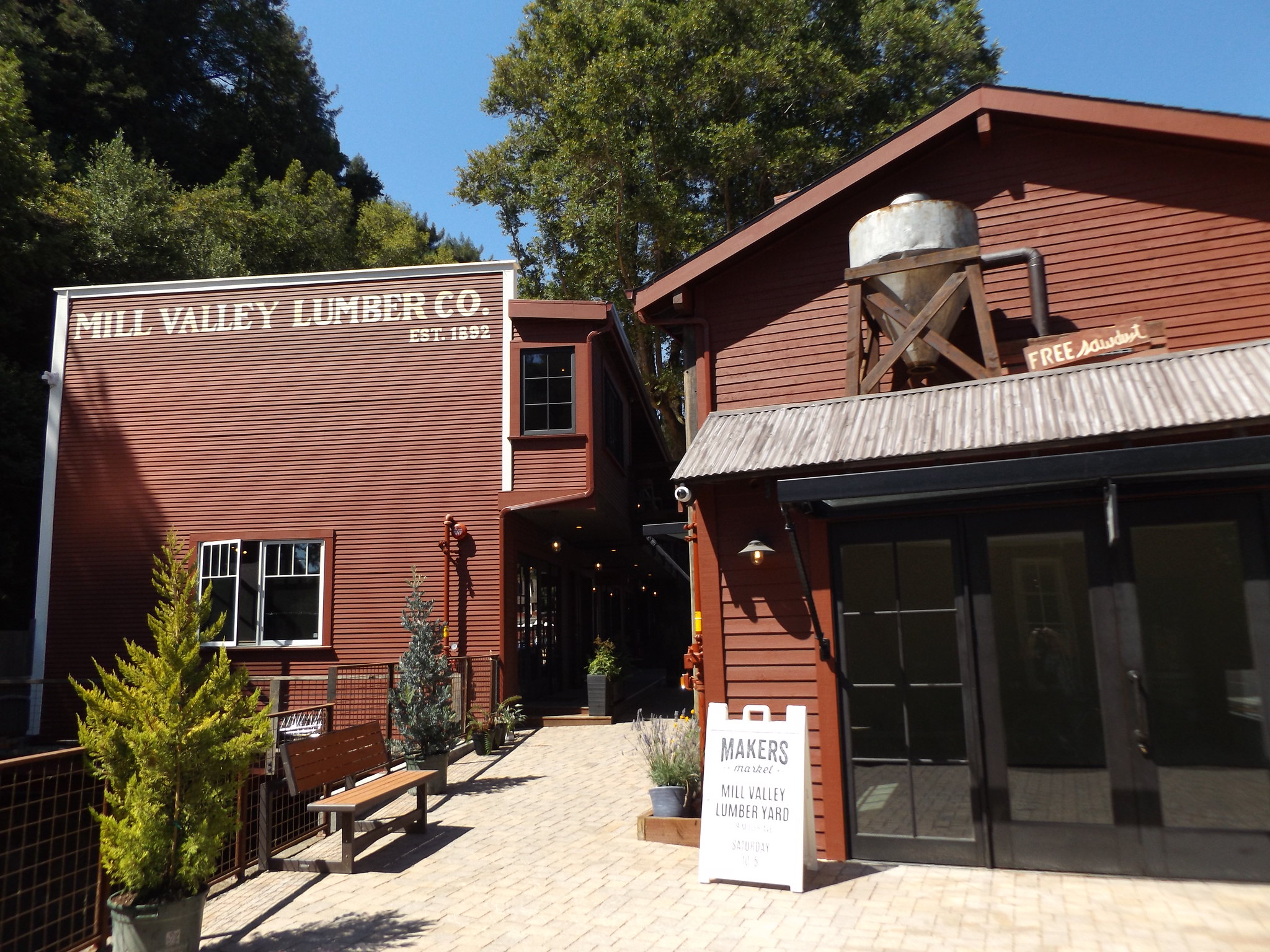
Before continuing around the bay to Tiburon, I decided to make a detour to Mill Valley, a small town nestling among woodlands at the foot of Mount Tamalpais. On the way into town along Miller Avenue, I stopped at an old timber yard that has been sensitively converted into upmarket retail units and cafés. Continuing along Miller Avenue, I arrived at Mill Valley’s bustling central square, where there was a replica of one of the gravity cars operated by the Mount Tamalpais and Muir Woods Scenic Railway, which was in service from 1896 until 1930. The gravity cars were towed to the summit by steam locomotives, before coasting down the mountain full of passengers. A “gravityman” was employed to operate the brakes on the descent, limiting the speed to 12 mph.
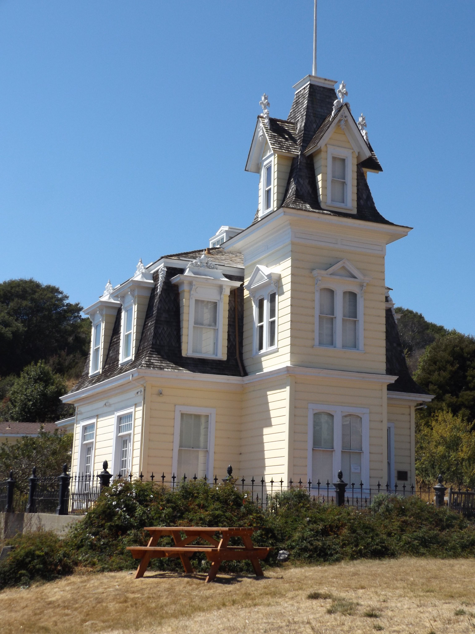
Leaving Mill Valley, I cycled through a leafy residential area before skirting around the coast of Richardson Bay towards Tiburon. Having a problem with my bicycle chain, I pulled into a layby to reattach the chain to the gears, and realised that I was by the entrance to the National Audubon Society’s regional headquarters at Richardson Bay. Within the grounds there was a small nature reserve, but in the early afternoon heat there were no birds to see apart from a single spotted sandpiper foraging on the beach. Overlooking the bay there was a striking cream-coloured Victorian house with a tall tower on one side. Originally built on nearby Strawberry Point in 1876, Lyford House was moved by barge, fully intact, to its current location in 1957. Photographs online show the entire three-storey house being transported across Richardson Bay.
From Lyford House, it was just a short ride to the centre of Tiburon. The town’s unusual name comes from the Spanish word for shark, tiburón. Spanish settlers arriving in 1775 named the nearby headland Punta del Tiburón, perhaps because they saw sharks nearby or because the shape of the peninsula resembled a shark.
Tiburon was less immediately attractive than Sausalito, approached via a wide road lined with car parks and retail units. Although there were some picturesque old buildings lining the short main street, the town centre was dominated by a large, modern housing development.

The reason for the lack of older buildings became clear when I visited the Tiburon Railroad Museum by the waterfront. On the ground floor of the museum there is a spectacular scale model of Tiburon as it was in the heyday of the railway in the first decade of the 20th century, when much of the area was a vast rail freight terminal. The railway to Tiburon was built in the 1880s by an Irish immigrant, Peter Donahue, to link with the ferries across San Francisco Bay. Passenger and freight trains ran until 1967, after which the railway was dismantled and the new housing complex was subsequently built in its place. All that remains of the railway is the museum building itself, constructed in 1884 to serve as the main station house. Upstairs, I was given a guided tour of the rooms in which the stationmaster, William Bent, and his family lived from 1913 until 1940.
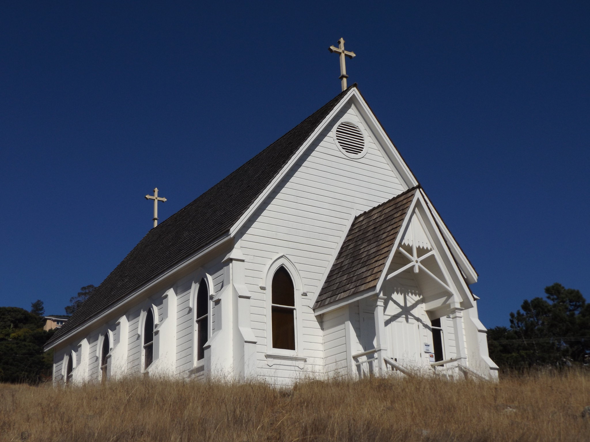
With half an hour to spare before the ferry, I pushed the bike up the steep hill to the north of the town centre, at the top of which stood Old St Hilary’s Church, a simple, white-painted wooden church in “Carpenter’s Gothic” style, which was built in 1888 as a place of worship for the railway workers. As I freewheeled back down the hill into town, there was an impressive view of the San Francisco skyline in the distance.
When I arrived at the ferry pier, there was a long queue of pedestrians and cyclists waiting to board the ferry back to San Francisco. The Blue and Gold Fleet ferry “Royal Star” wasn’t a very large vessel, and I wondered whether it would be able to accommodate everyone waiting at the jetty. Boarding the ferry, cyclists were instructed to leave their bikes in a heap on the lower deck. There were a lot of very similar-looking bikes from the same rental outlets, so I made a careful note of the colour sequence of the bikes above and below mine to ensure that I collected the same bike at the end of the journey, before climbing the stairs to the upper deck.
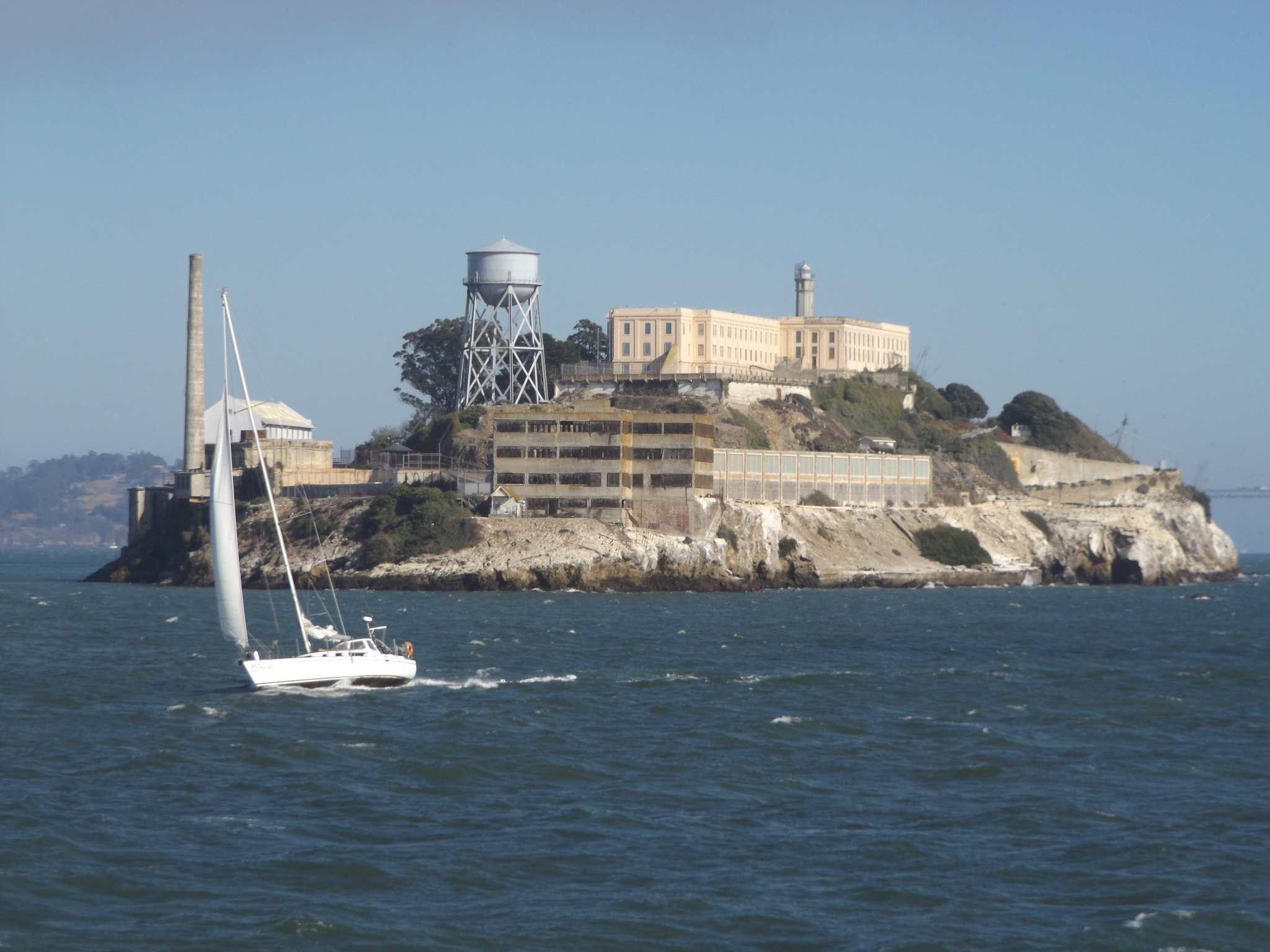
The crossing to San Francisco took about half an hour. There was a strong breeze and the boat was tossed from side to side by the foaming waves, making it difficult to take photographs of the spectacular Golden Gate Bridge across the sparking waters. Passing close by Alcatraz Island on our left, the ferry began to approach Pier 41, the skyline dominated by the triple landmarks of Coit Tower, the Salesforce Tower and the Transamerica Pyramid. After retrieving my bike, I disembarked on to the bustling waterfront and completed one last circuit of the streets around Fisherman’s Wharf before returning the bike to Blazing Saddles.
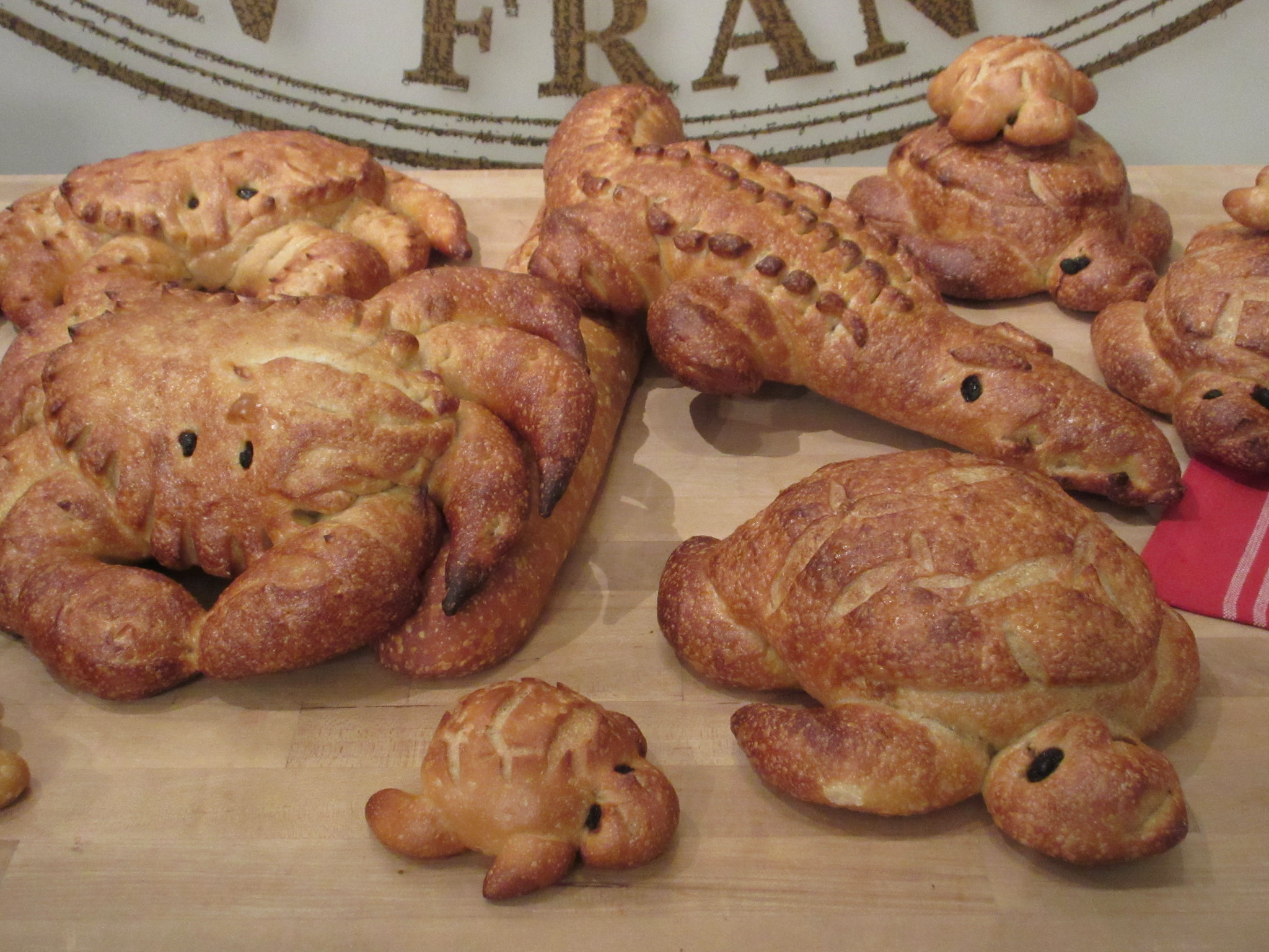
That evening, I walked along the waterfront looking for somewhere to eat, and found myself standing in front of a large glass window through which could be seen bakers’ ovens, racks full of freshly baked bread and staff in white overalls hard at work. There was a window display of bread rolls in the shape of teddy bears, crabs, turtles and crocodiles. Boudin Bakery is a famous San Francisco institution founded in 1849 by Isidore Boudin. The bakery complex included a bistro, shop and café, where I decided to try one of Boudin’s specialities: clam chowder served in a bowl made of sourdough bread. Having eaten as much sourdough as I could manage, I went upstairs to look around the bakery’s unexpectedly interesting museum, which tells the history of the bakery in the context of San Francisco’s wider social history.
Day 7: The Mission, Twin Peaks and Downtown San Francisco
Having three days left until my flight back to London, I decided to buy a 3-day Muni passport, allowing me to make full use of San Francisco’s transport system (including the cable cars, for which single tickets are expensive) to explore the different areas of the city.
Early on the Saturday morning, I went to the ticket kiosk next to the Powell-Mason cable car terminus to buy a Muni passport. Instead of boarding a Powell-Mason cable car, I climbed to the top of Lombard Street and took a Powell-Hyde cable car to Downtown.
Planning to explore the Mission District first, I caught a No. 14 bus down Mission Street. The crowded bus was full of assorted drunks and psychiatric cases, and at one point a man offered various passengers sweets before pulling an electric drill out of his bag, switching it on and waving it around. I was glad to get off the bus at the southern end of Mission Street near 25th Street.
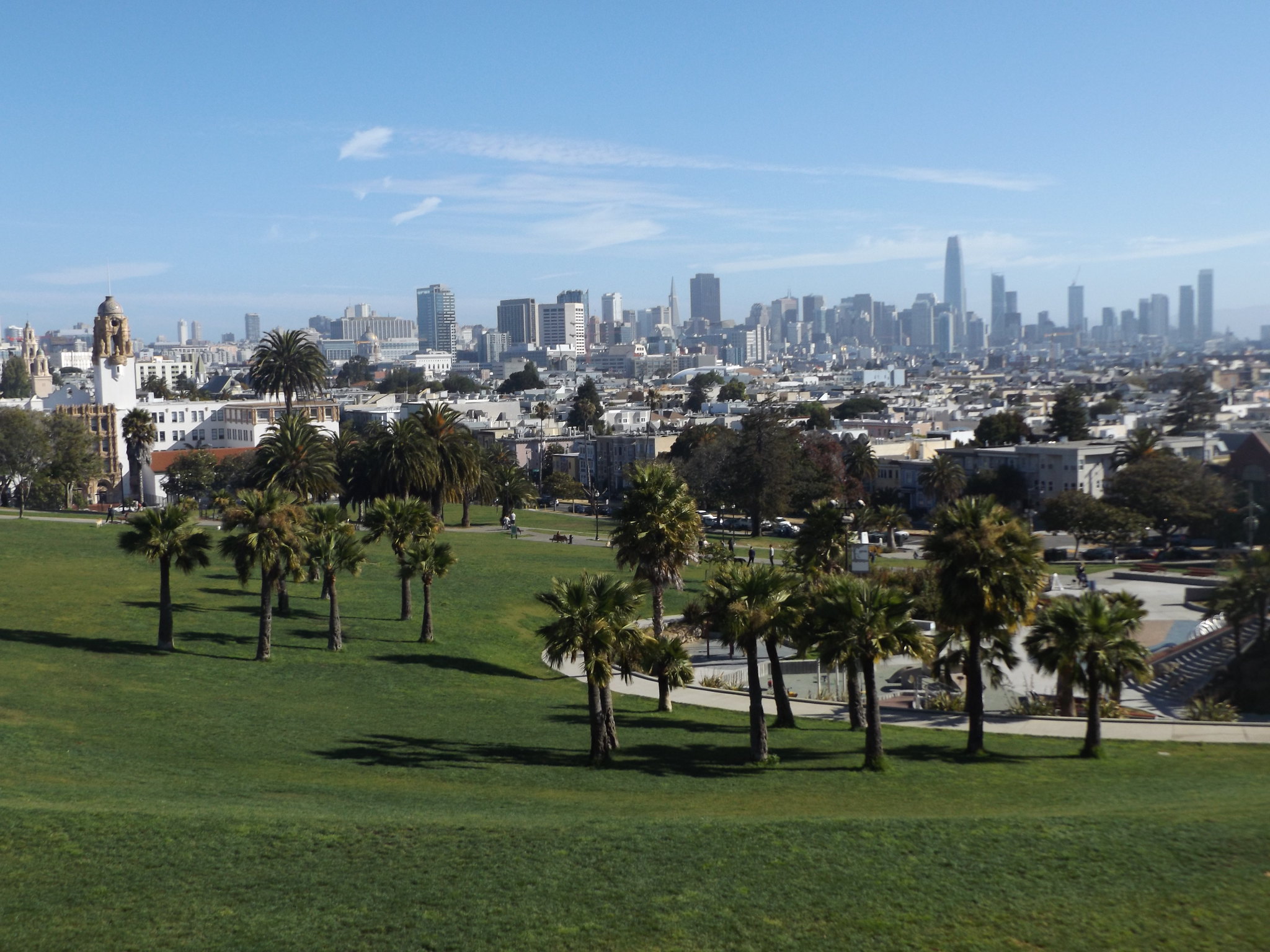
After looking at some of the murals in the back streets, I set off towards the Mission Dolores, one of San Francisco’s most important historic locations. A couple of blocks west of seedy Mission Street, I entered a more prosperous, leafy neighbourhood and turned right into Dolores Street, a long, wide thoroughfare with wooden Victorian houses on either side and palm trees along its central reservation. Over the crest of a hill, I reached the entrance to Dolores Park, a wide swathe of grass studded with palm trees. From the top end of the park, there was a fine view of the skyscrapers of Downtown San Francisco.
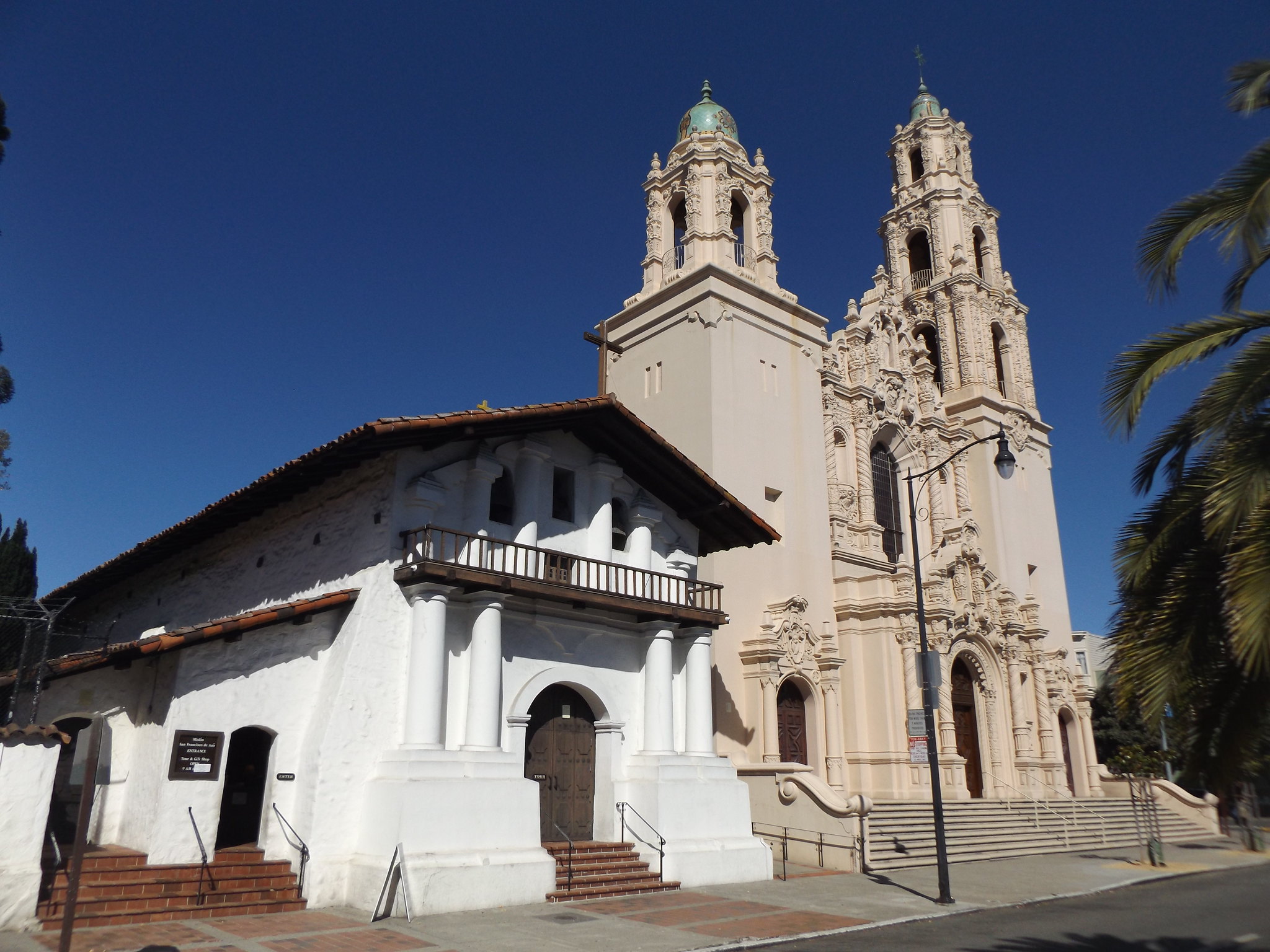
At the Mission Dolores, I paid the entrance fee and was handed a leaflet for the self-guided tour of the Mission church and the adjacent Basilica. The Mission Dolores is one of several famous San Francisco landmarks to feature in Alfred Hitchcock’s Vertigo. Officially known as the Mission San Francisco de Asis, it was founded in 1776 as part of the California Chain of Missions. The low, white building to the left of the Basilica houses the Mission church. Consecrated in 1791, it is San Francisco’s oldest building, with four foot deep adobe walls. A larger brick church was built alongside it in the 1870s to serve the growing population of the area, but collapsed in the 1906 earthquake. The present Basilica, with its flamboyantly ornate Baroque-style façade, was built to replace it in 1913-18. Its stained-glass windows depict St Francis of Assisi and the 21 California Missions. At the back of the old Mission church, there is a small museum displaying religious artefacts as well as an exhibition on the Native American Ohlone people who once inhabited the area. There is a replica Ohlone hut in the beautiful wooded cemetery next to the old Mission church.
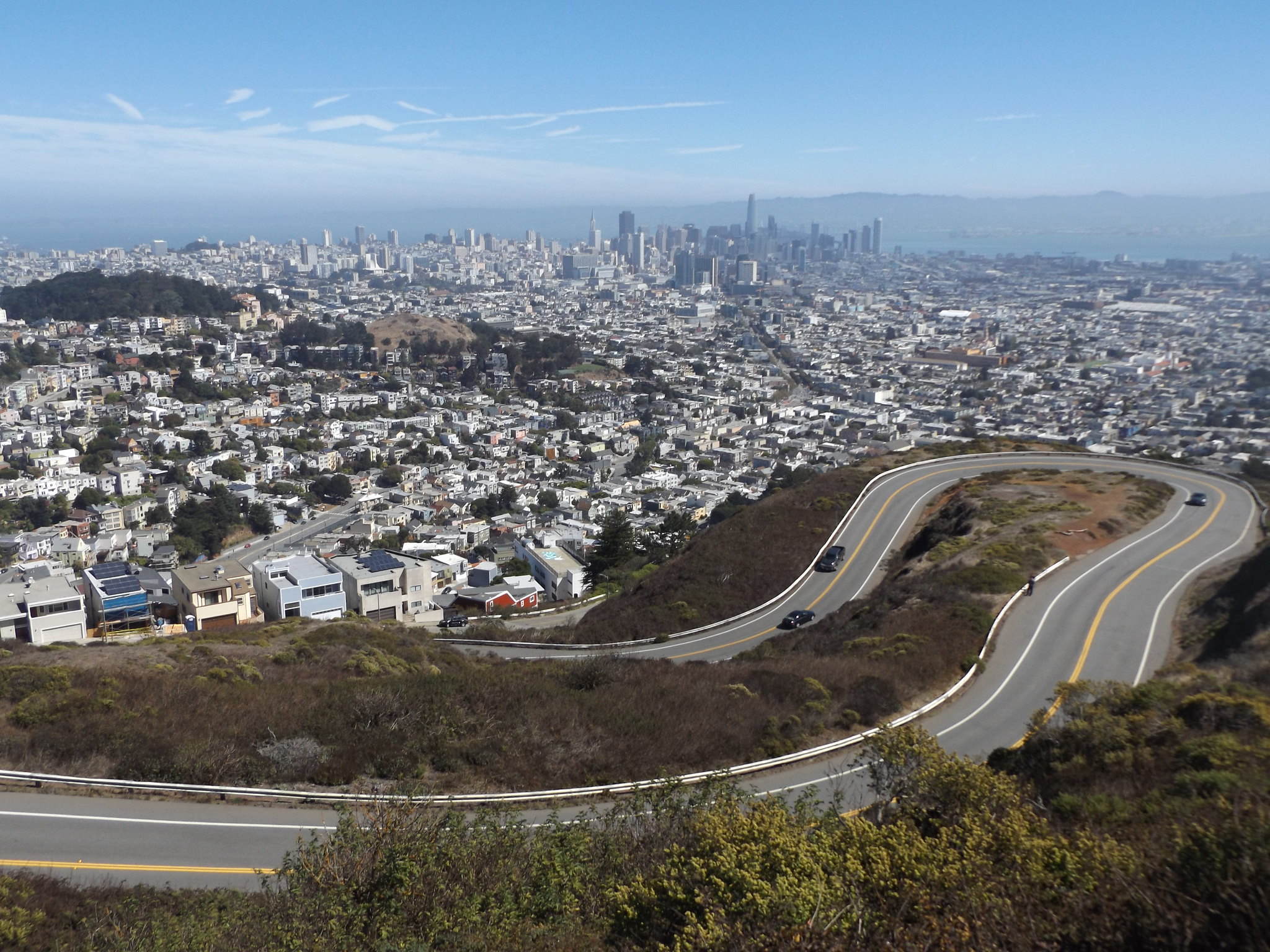
At the tram stop opposite the Mission, I met a British couple who were only in San Francisco for a couple of days as part of a whistle-stop tour of California. They mentioned that top of their list of things to do in San Francisco was to climb the Twin Peaks. I immediately decided that as the weather was so good I would head there next. Leaving the couple waiting at the tram stop, I walked the short distance to the Castro, where I was just in time to catch a No. 37 bus, which wound its way through the residential neighbourhood hugging the steep flanks of the Twin Peaks. From the bus stop near the top of the hill, it was a short climb to the bare grassy slopes of the Twin Peaks, which offered spectacular views over the city.
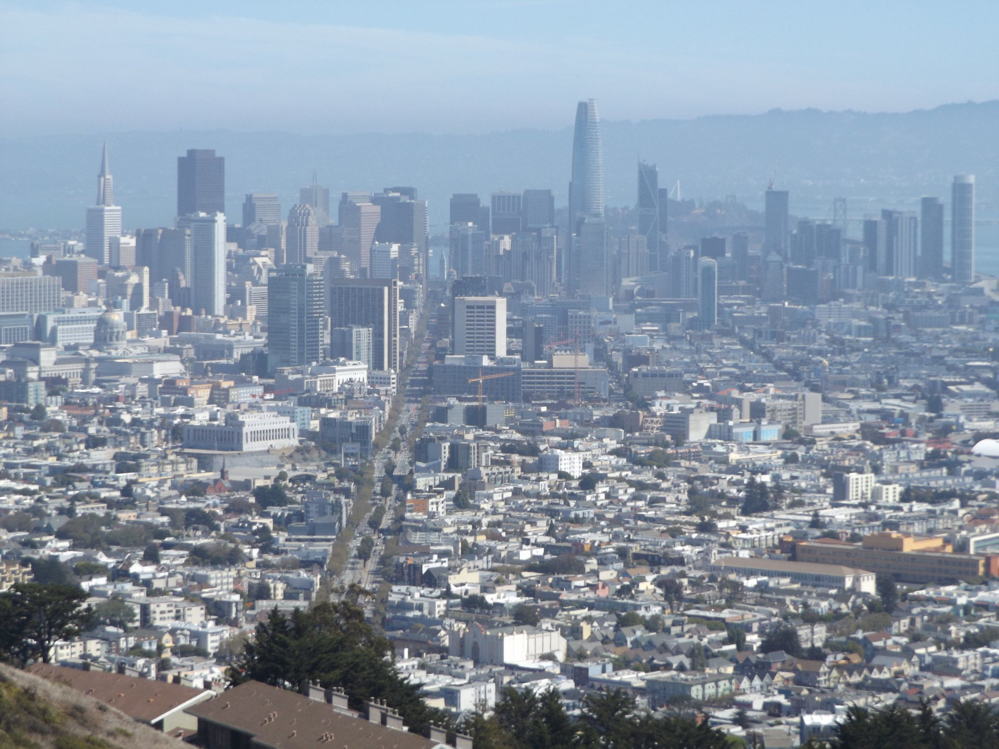
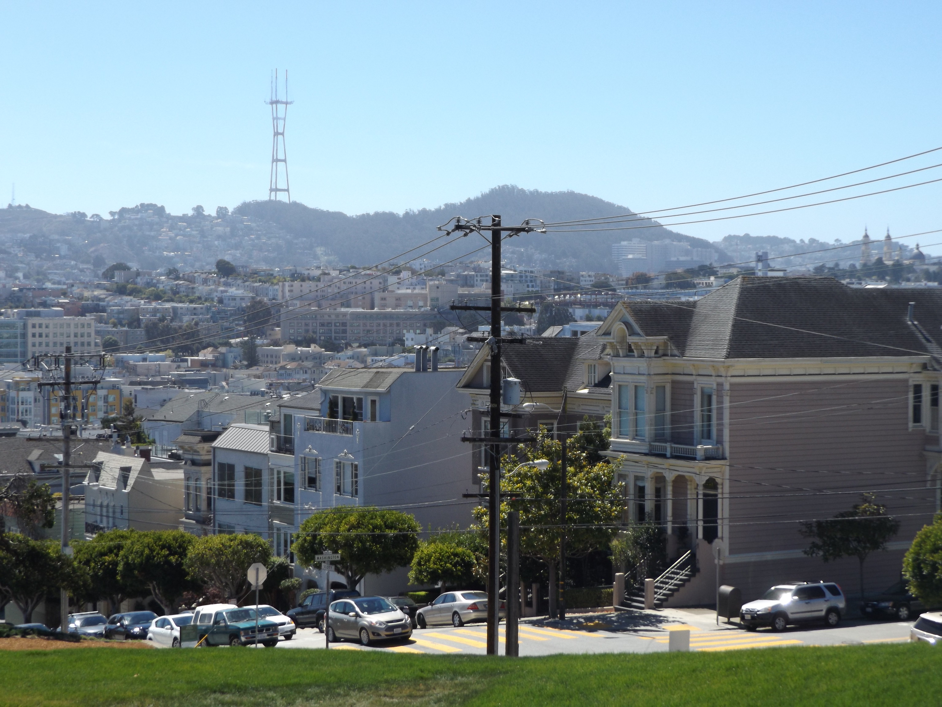
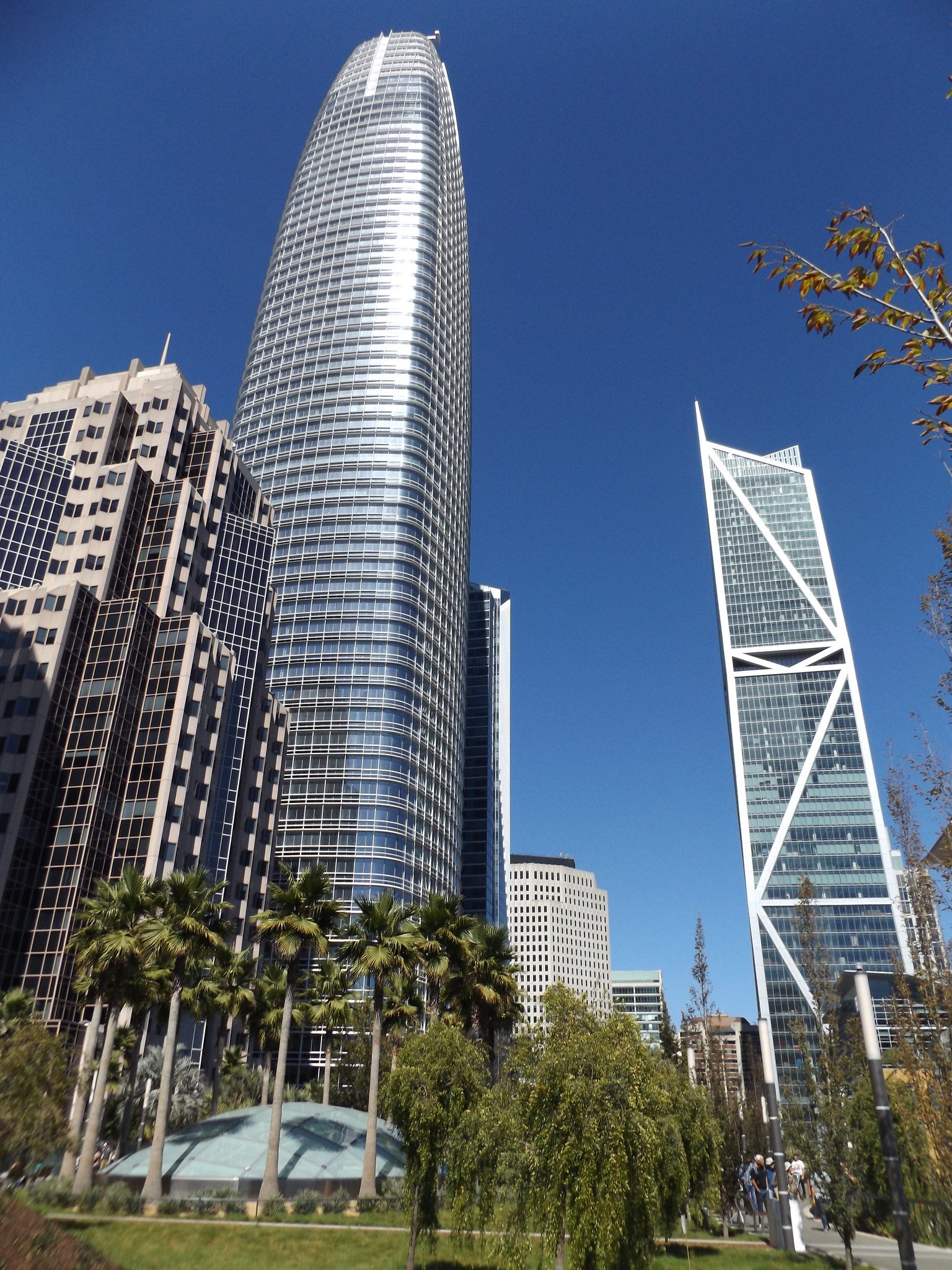
At 282 metres, the higher of the Twin Peaks is not quite the highest point in the city, as Mount Davidson to the south reaches 283 metres. The chain of hills traps the coastal fog which rolls in off the Pacific during the summer months, making the western slopes especially prone to being shrouded in fog. Luckily, there was an almost cloudless blue sky and bright sunshine, although it was very windy at the summit. The most impressive view was to the north-east, along the ruler-straight Market Street towards Downtown, with its cluster of skyscrapers dominated by the 326m-high Salesforce Tower.
To the east, low-rise houses arranged in straight rows stretched as far as the edge of San Francisco Bay, beyond which the hills of Alameda County on the far side of the Bay were just visible through the haze. Immediately to the north of the Twin Peaks was the forest-covered Mount Sutro (277 metres) and its enormous TV tower, which actually stands on a separate, lower hill between Mount Sutro and the Twin Peaks. The Golden Gate Bridge could just about be seen, cloaked in a patch of mist stretching from the Presidio to the Marin Headlands. I noticed that there were several police cars cruising along the road below the twin summits; I wondered whether they were patrolling the area for car crime or just enjoying the breathtaking views. Down by the road, there was another fantastic viewpoint overlooking a sharp bend in the road, which resembled a motor racing circuit.
After admiring the stunning views from the tops of the Twin Peaks, I set off down the twisting road back to the Castro. There, I boarded a No. 24 bus northwards towards Pacific Heights, getting off near Alta Plaza.
San Francisco’s most exclusive neighbourhood, and possibly the most expensive residential area in the whole of the United States, Pacific Heights sits on a long ridge stretching westwards from Downtown. Like much of the city, its streets are arranged in a strict grid pattern, with two rectangular parks, Alta Plaza and Lafayette Park, at either end of the district. North of Jackson Street, the streets descend steeply to the Marina District, providing good views of Tiburon, Angel Island and Alcatraz.
A couple of blocks north of Alta Plaza, on the corner of Broadway and Steiner Street, is the “Mrs Doubtfire” house, a relatively low-key, grey-painted wooden house with circular corner turrets. Unusually, its actual address, 2640 Steiner Street, was mentioned in the movie, and because of its well-known location it became an impromptu shrine to Robin Williams when he died in 2014. The house was on the market for almost $4.5 million in 2016, and some of the more extravagant houses in the area have sold for as much as $40 million.
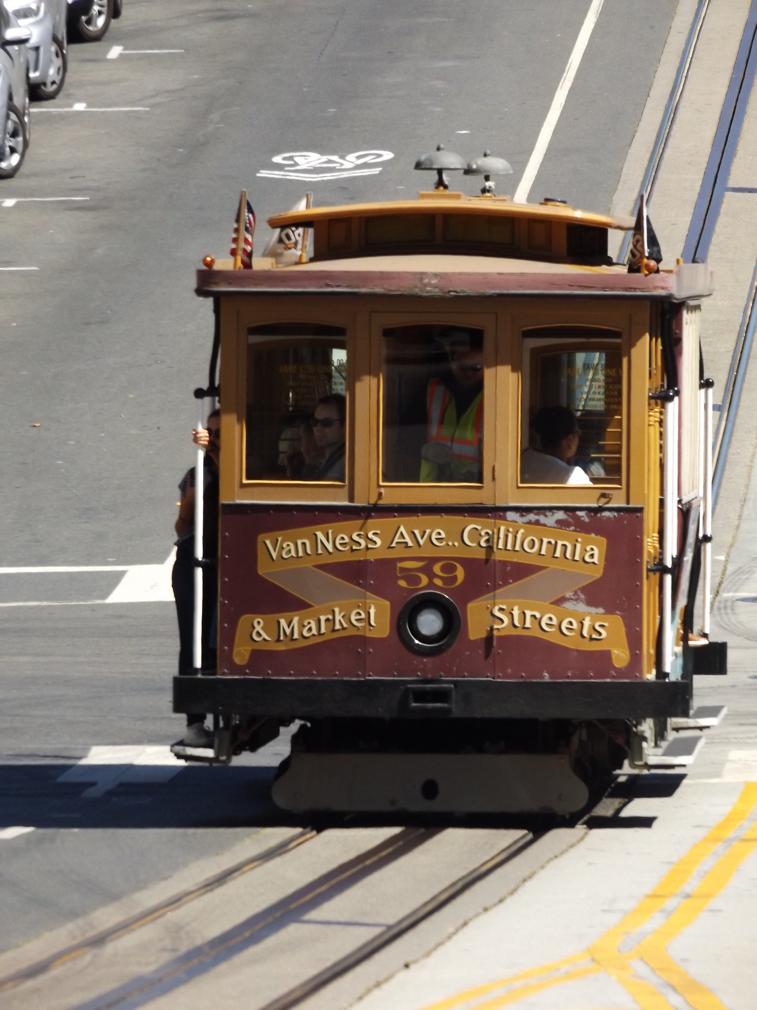
Walking through Lafayette Park, I arrived at Van Ness Avenue, the busy dual carriageway running north-south along the western edge of Downtown San Francisco. Across the road, I spotted a group of people waiting at a cable car stop, and it was not long before a cable car arrived for the ride along California Street into the heart of Downtown.
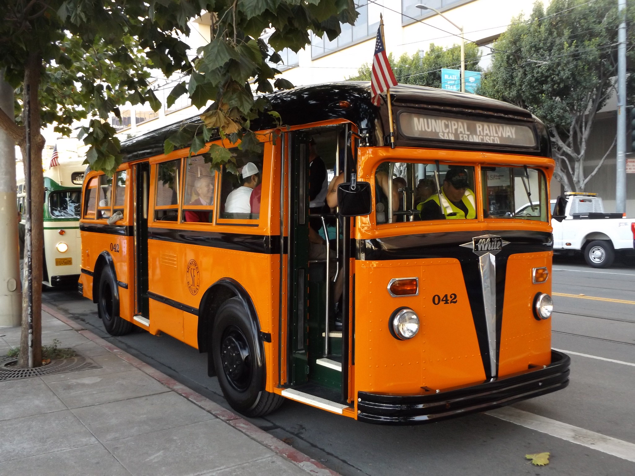
Near the Ferry Building, I had a brief look inside the San Francisco Railway Museum, which was really just a shop selling transport books and souvenirs, with a small display of interpretation boards explaining the history of San Francisco’s municipal transport system. More interesting were the vintage buses parked outside the museum, including this 1938 White Motor Co. bus, which were offering free rides as part of a Muni heritage weekend.
While I was in the area, I decided to have a look at the rooftop garden of the new Salesforce Transit Center, which opened in August 2018. The 440 metre-long transport interchange, built to replace the old Transbay Terminal, had cost $2.2 billion so far, and plans to incorporate a new railway station within the complex were expected to cost a further $6 billion. With its lush botanical gardens and fountains, surrounded by towering skyscrapers, the rooftop garden was certainly spectacular. Unfortunately, only a couple of weeks after my visit, cracks were discovered in a couple of supporting steel beams, and the entire complex had to be closed for safety reasons. It had not reopened at the time of writing.
After a quick look at Yerba Buena Gardens, with its huge artificial waterfall, I walked back to the Ferry Building, where I had an unusually long wait for a streetcar back to Fisherman’s Wharf. Before going to the concert in the evening, there was time to visit the free Maritime National Park Visitor Center in a red-brick former cannery warehouse in Jefferson Street, with its reconstructions of old waterfront neighbourhoods and a wide variety of maritime artefacts.
In the evening, I went to a concert given by the San Francisco Symphony Orchestra, conducted by Michael Tilson Thomas. The orchestra had given its opening gala concert for the 2018-19 season a few nights earlier, with eye-wateringly expensive tickets and an exclusive reception for patrons. This was to be followed by two concerts with tickets at just $10, which were given for the benefit of staff working in San Francisco’s social and educational services, although there were plenty of spare tickets for the general public.
When I arrived at the Louise M. Davies Symphony Hall, there was a lively jazz band performing in the foyer. The ambience of the concert seemed very informal, with large numbers of people seeming to trickle into the auditorium for quite some time after the performance had begun.
After the orchestra had tuned up, Michael Tilson Thomas walked quickly to the podium, at which point the audience immediately rose to their feet as he flamboyantly conducted the “Star Spangled Banner” before beginning the main programme. The evening’s relatively short programme included a few of the pieces performed at the opening gala concert. The first half comprised Liszt’s Mephisto Waltz No. 1 and Tchaikovsky’s Rococo Variations for cello and orchestra, performed by a young San Franciscan cellist, Oliver Herbert. After the interval, the orchestra performed two pieces by Gershwin, the Cuban Overture and An American in Paris. Tilson Thomas, who is especially renowned for his performances of works by American composers, said a few words before each piece, amusing the audience with an anecdote about recent musicological research into the authentic pitches of the French taxi horns in An American in Paris.
Day 8: Marin Headlands
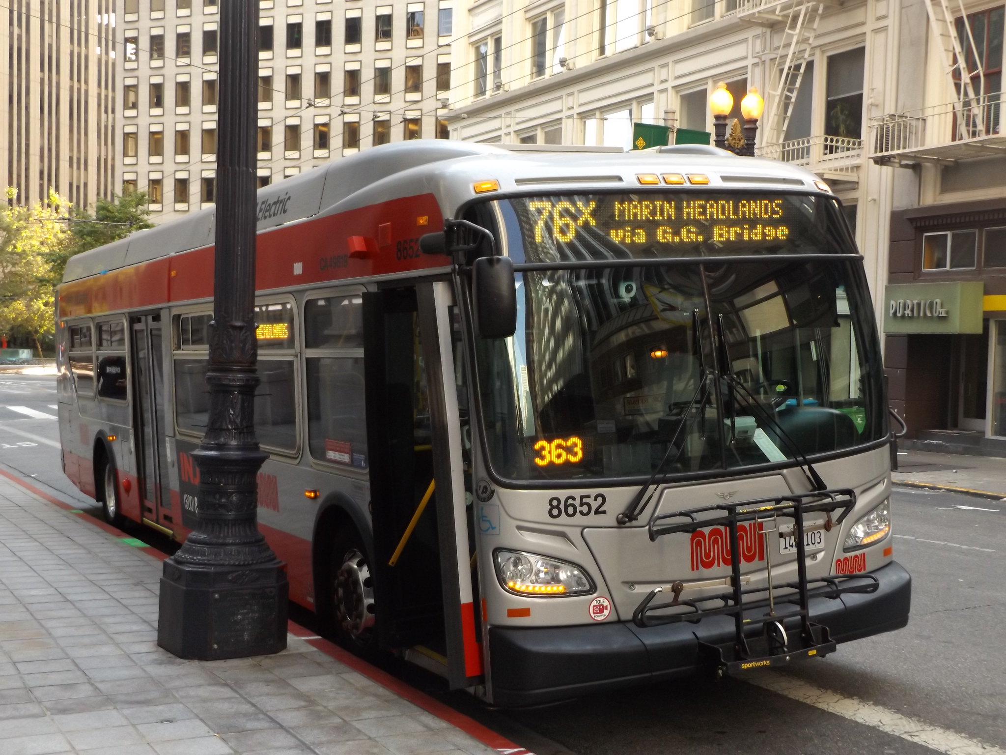
I decided to spend Sunday exploring the Marin Headlands, hoping to get some good photos of the Golden Gate Bridge in fine weather. A Muni bus, 76X, goes to the Marin Headlands on Saturdays and Sundays only, leaving from the junction of Sutter Street and Market Street in Downtown San Francisco. Leaving the hotel early, I rode into Downtown on a cable car before the queues started to build up. Arriving in the city centre with a long time to wait until the first bus, I walked towards Sutter Street where the stand for the 76X bus was located. The streets around the bus stop consisted mostly of office blocks, and there were quite a few homeless and drunk people hanging about the street corners. I was approached by a woman who asked whether I was a tourist, and wondered whether I should disclose the fact that I was a tourist, but it turned out that she only wanted to recommend a fantastic day out that I could have by catching a 76X bus to the Marin Headlands!
The bus set off along Sutter Street and Van Ness Avenue, passing through the suburbs on its way towards the Golden Gate Bridge. It slowly filled up with passengers, most of whom seemed to recognise each other as regulars who made a weekly Sunday outing to the Marin Headlands. After speeding across the Golden Gate Bridge, the bus turned off the freeway and began to climb the steep Conzelman Road, which offered spectacular views over the Golden Gate and the Pacific Ocean.
I got off the bus near the Nike missile site, one of two Cold War nuclear missile sites on the Marin Headlands, which was in operation from 1955 until 1974. On the hillside overlooking Rodeo Lagoon, a winding footpath led to the ruined early 20th century military installations of Battery O’Rorke, Battery Smith-Guthrie and Battery Alexander. After a quick look inside the Visitor Center in an old wooden church down by the lagoon, I walked along the southern shore of the pelican-studded lagoon towards the beach.
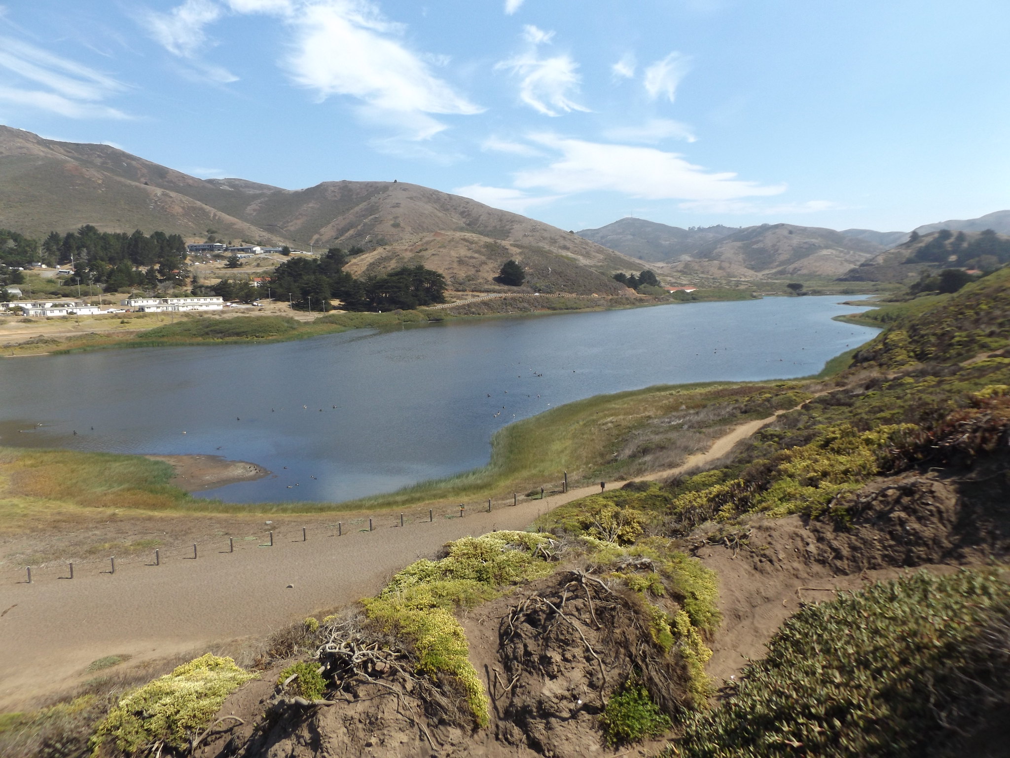
Rodeo Beach is a short sand bar separating the lagoon from the ocean, at the southern end of which a clump of jagged sea stacks rises abruptly from the surf. From there, a steep path climbs the sand dunes, meandering through a dense carpet of brightly coloured dune plants and flowers. At the tip of the Marin peninsula stands Point Bonita Lighthouse, reached via a tunnel through the rocks which is locked outside of lighthouse visiting hours. As the tunnel was closed when I arrived, I turned back along the path to the road, and set out along the twisting Conzelman Road in the direction of the Golden Gate Bridge.
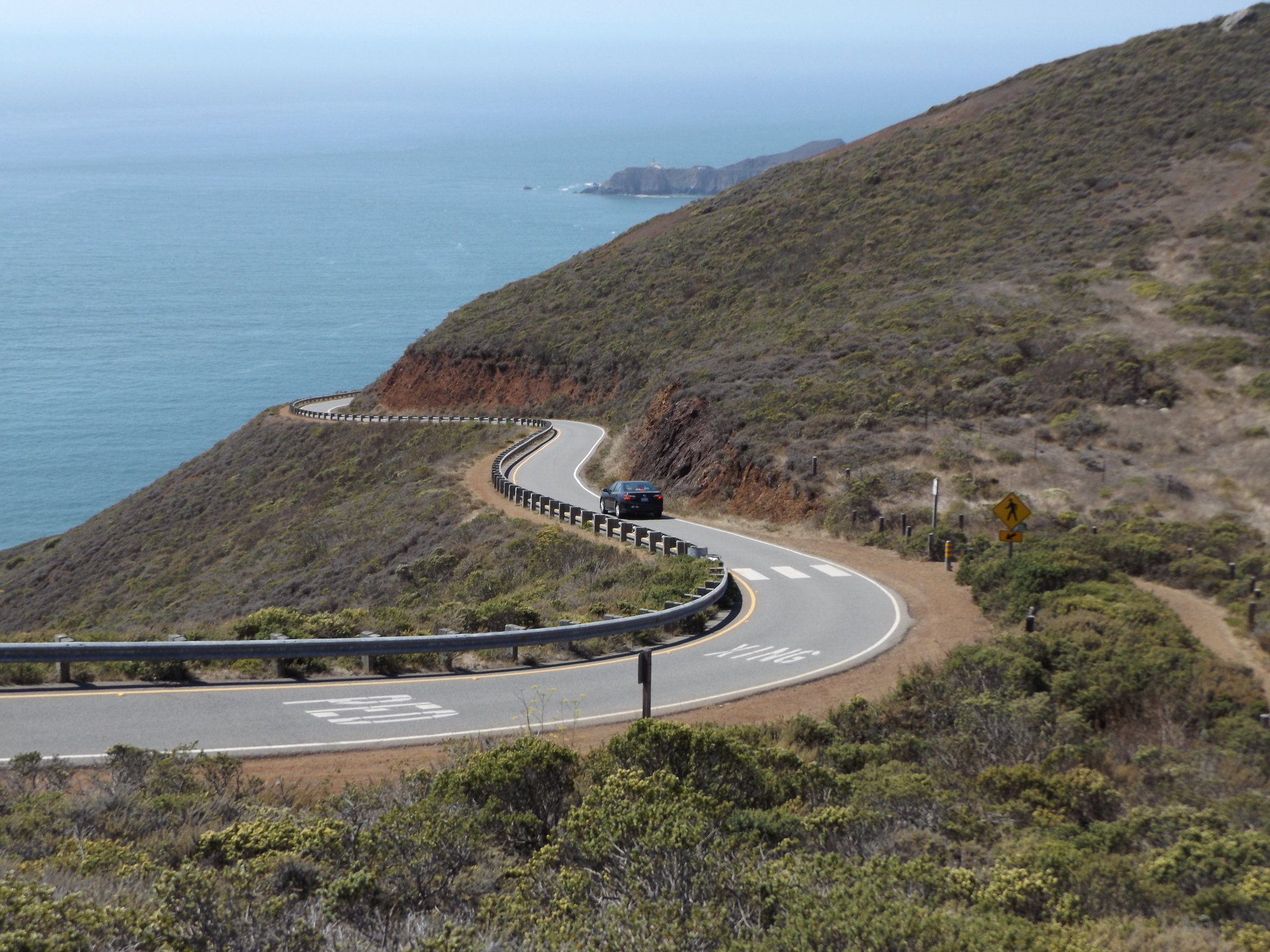
After a couple of miles, I turned off the road to climb the steep path up to the 278-metre summit of Hawk Hill. At the top of the hill was another abandoned military fortification, Battery 129. Built in 1942-44 to serve as a defence against the threat of Japanese invasion, the battery was abandoned before completion in 1944 when it became clear that there would not be a Japanese attack on American ports. Passing through one of the battery’s entrance tunnels, I emerged back on to Conzelman Road. In front of me was one of the world’s most spectacular views: the 1.7 mile long Golden Gate Bridge spanning the mouth of San Francisco Bay; the calm, blue surface of the bay studded with tiny yachts; and in the far distance the skyscrapers of Downtown San Francisco and the Bay Bridge.
Conzelman Road wound its way along the hillside for another mile and a half down to Vista Point at the northern end of the bridge, giving fabulous views over the Golden Gate. Large numbers of people were admiring the views and taking photographs at the various parking areas along the road. Red-tailed hawks and turkey vultures could be seen soaring over the hills on the thermals.
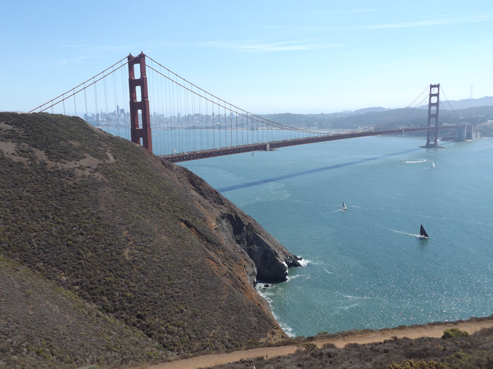
Crossing the bridge took nearly half an hour, with plenty of stops to take photos. The total length of the bridge is 2,737 metres (about 1.7 miles), with a distance of 1,280 metres between the two towers. The bridge carries a six-lane dual carriageway, with narrow sidewalks on either side (pedestrians use the eastern sidewalk). Built in 1933-7, it is considered to be one of the world’s greatest masterpieces of Art Deco design and is probably the world’s most photographed bridge. From its opening in 1937 until 1964, it held the record for the world’s longest suspension bridge main span. The bridge takes its name from the narrow passage of water at the entrance to San Francisco Bay, which was named “Chrysopylae” (“Golden Gate”) by Major General John C. Fremont in 1846, alluding to the Golden Horn in Istanbul.
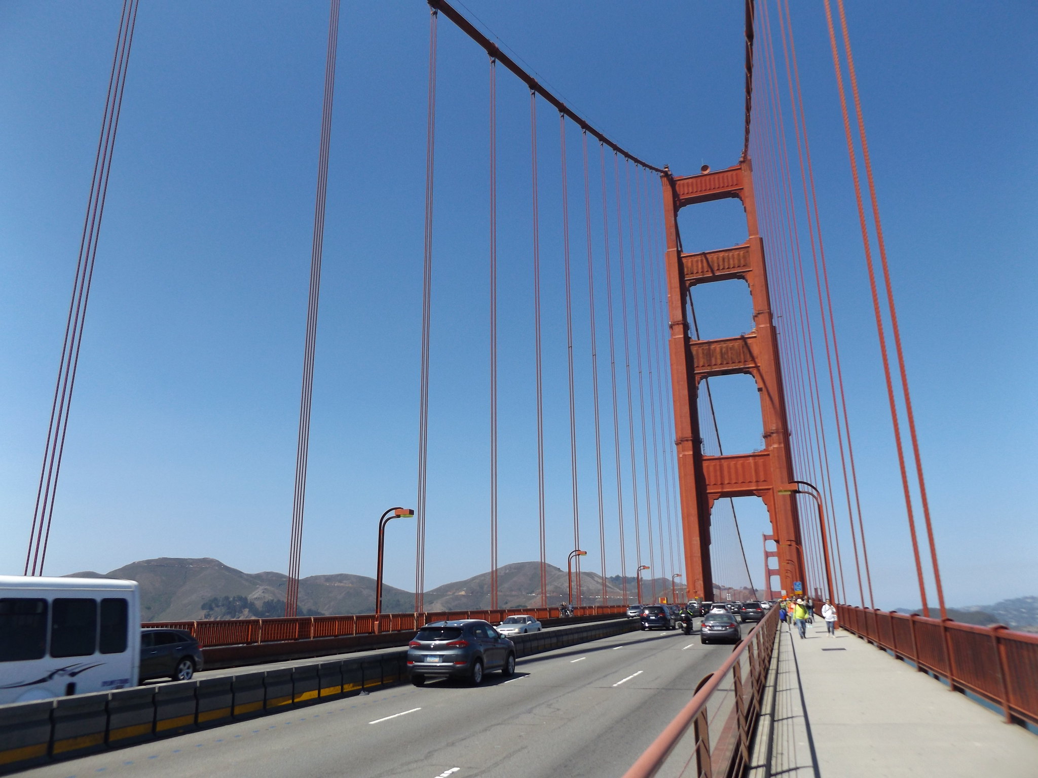
Although major work was being undertaken to install anti-suicide nets and to shore up the bridge against the threat of a major earthquake, the views of the bridge were largely unobstructed by scaffolding or other signs of construction work. When I reached the southern end of the bridge by the Toll Plaza, I decided to continue along the coastal path towards Baker Beach for one final view of the bridge from the south-west.
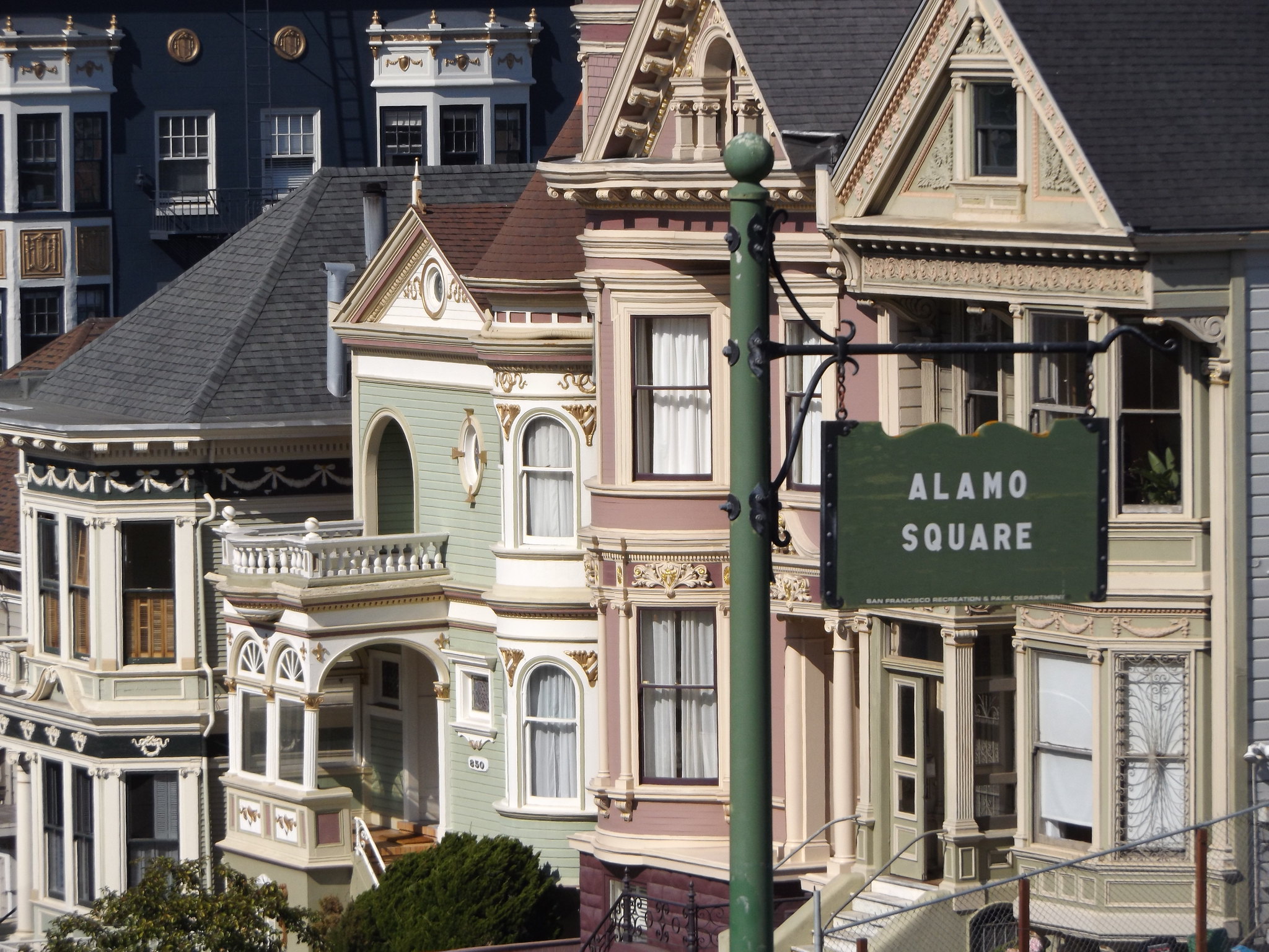
While I had been hiking along Conzelman Road from the Marin Headlands, one of my shoes had started to split, and after I tripped over a tree root the front of the sole started to separate from the upper. I had to walk quite some way to the nearest bus stop, from where I would need to take a minimum of three buses to get back to the hotel to change my shoes. In spite of my rapidly collapsing shoe, I decided that while I was in the area it would be a good idea to stop off at Alamo Square to take some photos of the famous “painted ladies”. I had spent my first four nights at a hotel near Alamo Square, but the weather had been cold and gloomy throughout that time. The bright afternoon sunshine and deep blue sky provided ideal conditions for photographing the picturesque row of ornate Victorian houses with a backdrop of skyscrapers, probably the most famous view in San Francisco after the Golden Gate Bridge.
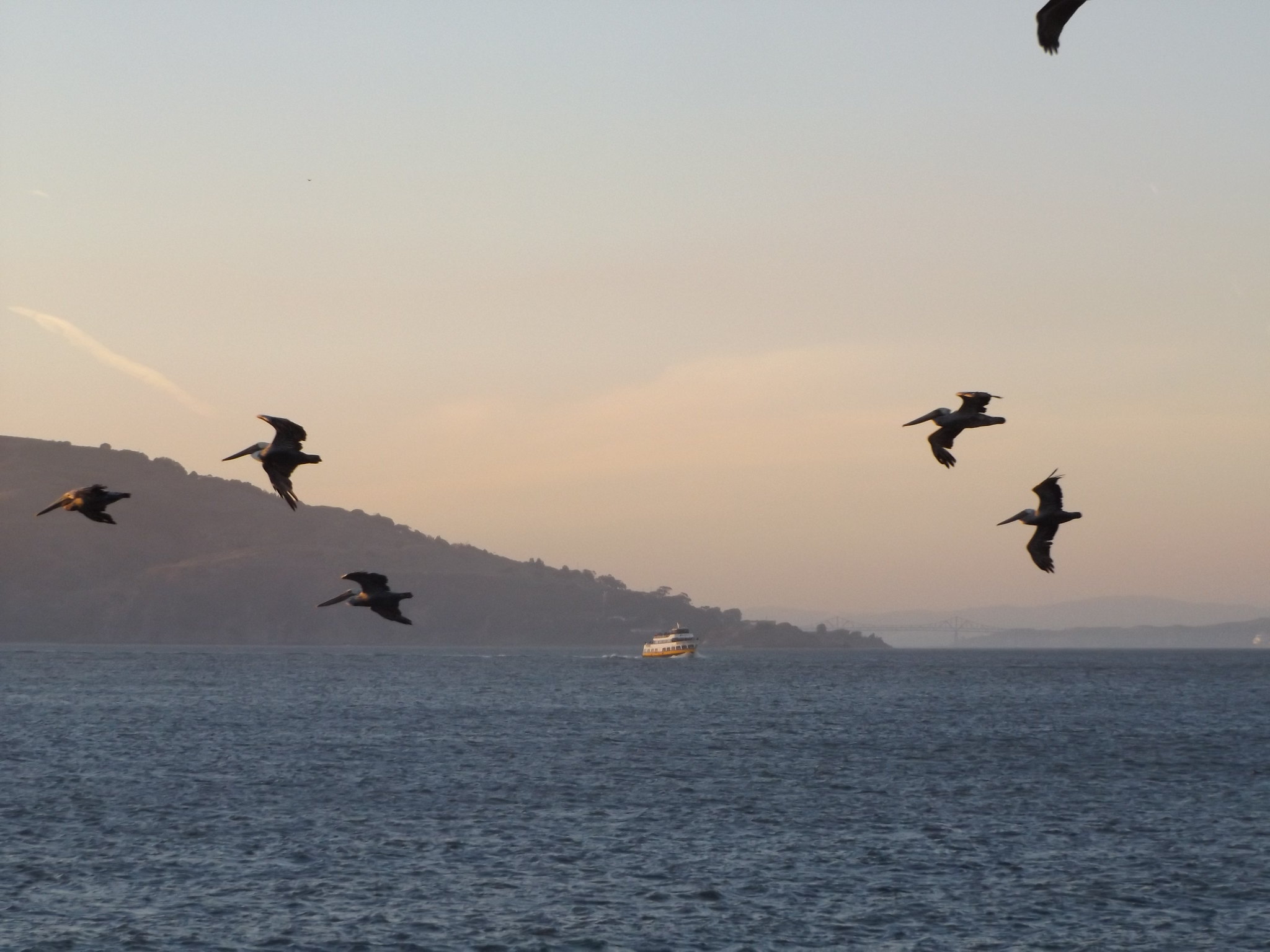
From Alamo Square it was a bus and a streetcar ride back to the hotel. In the evening, I walked down to Fisherman’s Wharf and bought some fried seafood from one of the stands at the bottom of Taylor Street. As the light faded, the sky was full of small groups of pelicans gliding over the water against the distant backdrop of Alcatraz and Angel Island. As usual, large numbers of California sea lions were lying on the pontoons beside Pier 39, barking noisily. I walked along Jefferson Street to the beach in front of the Maritime Museum to watch the sun setting over the Golden Gate Bridge.
Day 9: The Presidio
I checked out of the hotel early on the Monday morning, leaving my suitcase with reception as my flight was not until 7.30 pm. I took a cable car up to Nob Hill, and boarded a No. 1 bus along California Street to Mountain Lake, at the southern edge of the Presidio. Occupying the entire north-western corner of the San Francisco peninsula, the Presidio was once a vast US Army base, but became a national park after the Army’s departure in 1994. It was founded by Spanish settlers in 1776, becoming a Mexican military post in 1821 when the Republic of Mexico gained independence. In 1848, after the United States’ war with Mexico, a treaty was signed transferring California to the United States. The gold rush which followed California’s acquisition by the US resulted in the rapid growth of San Francisco in size and economic importance, prompting the US government to establish a major military base at the Presidio. Much of the area consists of forest, planted by the Army during the 19th century, which is home to a wide variety of wildlife. There are also residential neighbourhoods, sports facilities and other public amenities and various historic buildings from the Presidio’s military past.
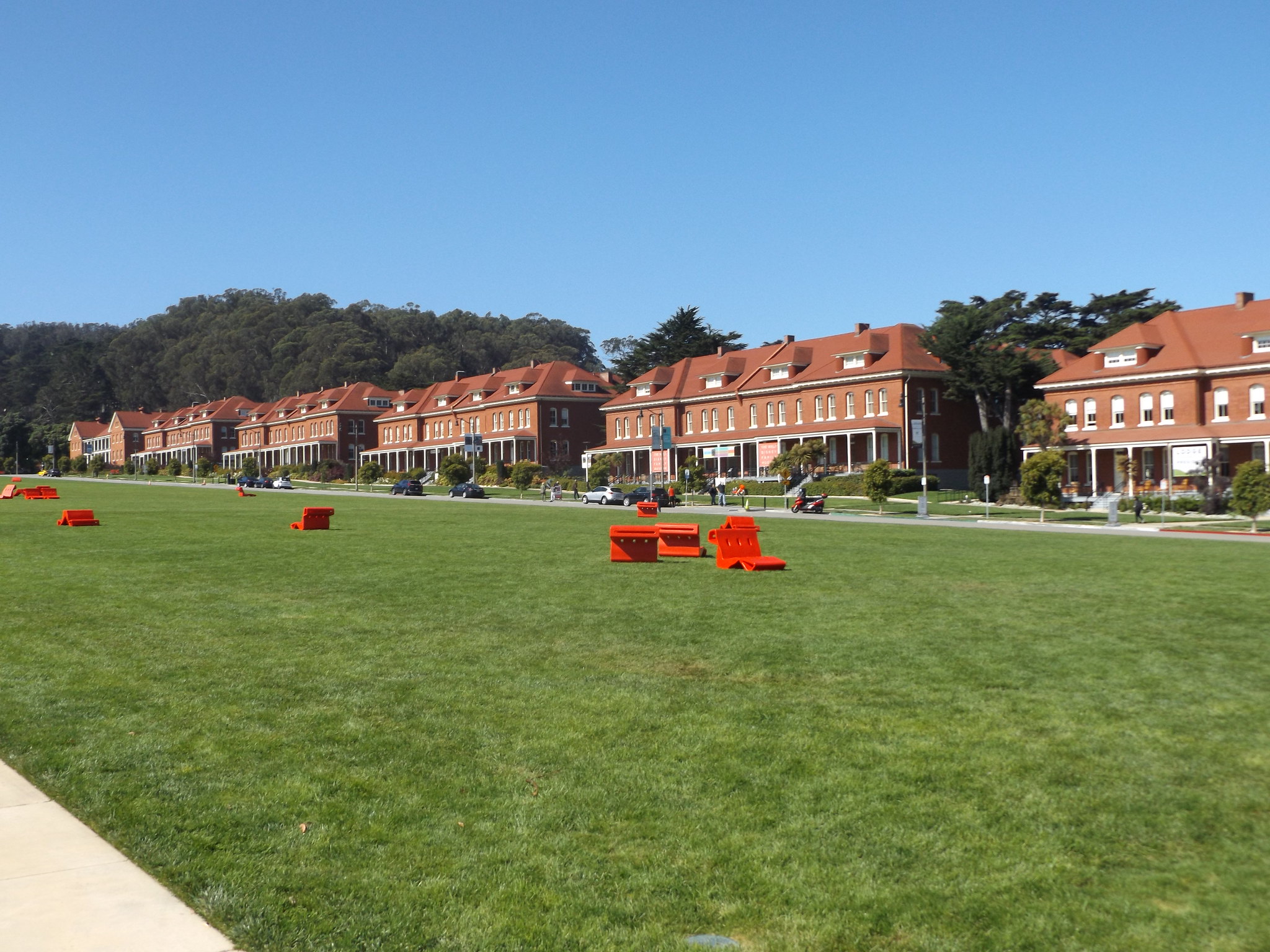
In the wilder southern part of the park, there are a number of art works by the British artist Andy Goldsworthy, including Spire, a 100 ft tall spike made from Monterey cypress trunks, and Wood Line, a zigzag path through a peaceful eucalyptus grove. At the northern end of the park is the Main Post of the former army base, centred on the Main Parade Ground with its row of harmonious red-brick buildings. Once used for military parades and ceremonies, the Main Parade Ground was concreted over in 1951 to create a vast car park, but this was replaced by grass in 1991, giving the area the appearance of an English garden suburb.
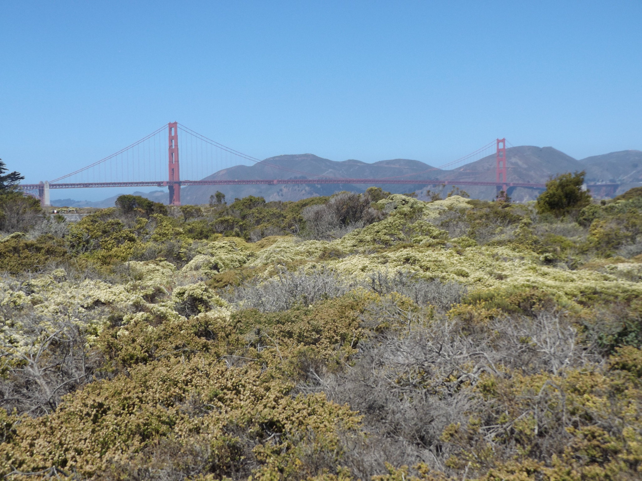
Opposite the Main Parade Ground, there is a Visitor Center with displays and leaflets about the Presidio’s history and wildlife. On the other side of Highway 101, the former military airbase at Crissy Field has been turned into a wetland nature reserve, with herons, egrets, long-billed curlews and other shorebirds. Beyond the reserve, there is a long sandy beach with good views of the Golden Gate Bridge.
In the north-eastern corner of the Presidio area, on the edge of the Marina District, is one of San Francisco’s most beautiful sights: the Palace of Fine Arts. It was designed by Bernard Maybeck for the 1915 Panama-Pacific Exhibition as a mock Graeco-Roman ruin. The Palace’s popularity led to the decision to preserve it when most of the other structures built for the Exhibition were demolished. However, because it was never intended to be more than a temporary structure, it soon began to fall into disrepair. In 1965, it was dismantled and rebuilt using more durable materials.
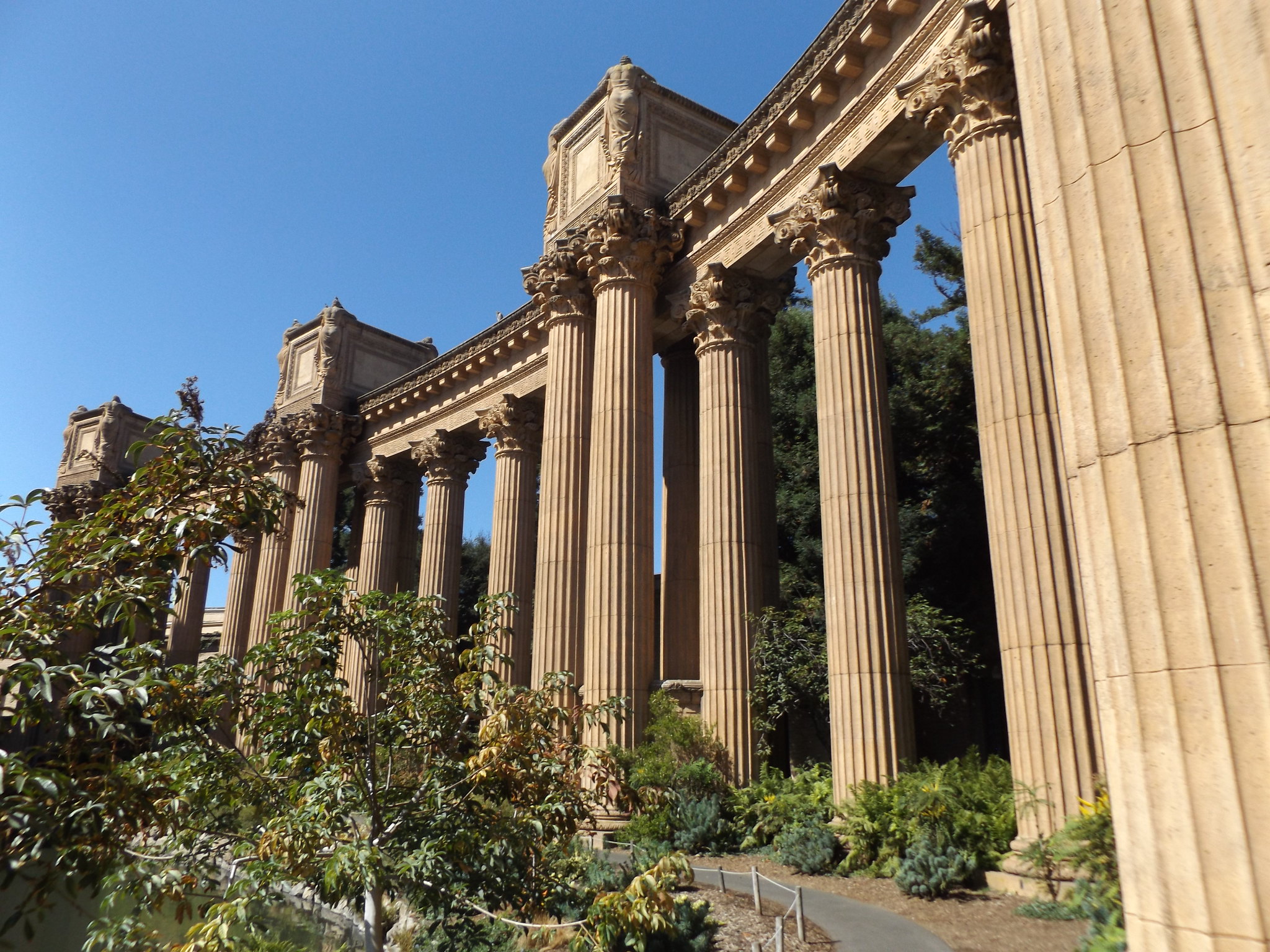
Walking among the Palace’s Corinthian columns in the hot midday sunshine, I almost imagined that I was strolling through an Ancient Greek or Roman temple in the Mediterranean, although the colonnades were in fact built of concrete in 1965! One striking detail is the inward-facing “weeping women” sculptures by Ulric Ellerhusen on the tops of the colonnades.
The Palace sits beside a beautiful lagoon, which is home to mute swans, ducks and turtles. In one corner of the lagoon, under the shade of trees, large groups of snowy egrets and black-crowned night herons huddle on the branches.

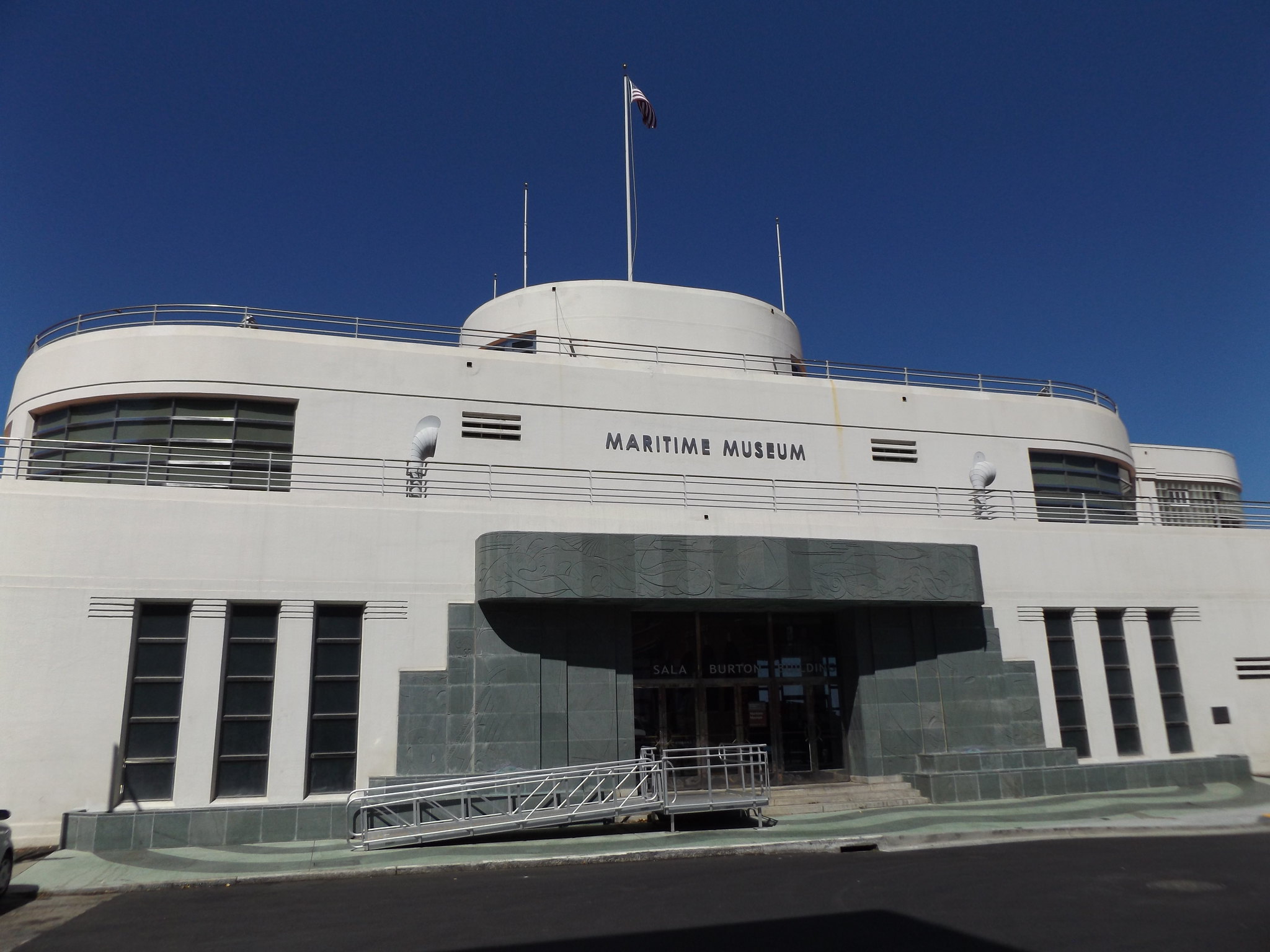
From the Palace of Fine Arts, I caught a bus to Downtown San Francisco for a quick look at the impressive rotunda inside the Neiman Marcus department store in Union Square, before returning to Fisherman’s Wharf. Before setting off for the airport, there was just time to visit the free Maritime Museum next to the beach in Aquatic Park. The museum’s distinctive building, resembling a double-ended ferry boat, was constructed in 1939 in “streamline moderne” style (a late form of art deco) to serve as a public bath house. The interior walls are covered in colourful murals depicting fish and other marine life. The museum includes a display about Kenichi Horie, a Japanese yachtsman who made the first solo crossing of the Pacific Ocean from Osaka to San Francisco in 1962, at the age of 23. Completing the 5,300-mile voyage in his tiny 19-foot plywood boat, Mermaid, took 94 days.
After visiting the museum, it was time to head back to the hotel to collect my suitcase. As my 3-day Muni passport was still valid, I decided to catch one of the modern trams which ran underneath Market Street down to Balboa Park at the southern end of the city, where I would be able to connect to the BART back to the airport. A few hours later, the Virgin Atlantic flight departed for the 10-hour journey back to London.

2 thoughts on “San Francisco – Part 2”