Visited on: Sunday 2 – Wednesday 5 September 2018
For anyone who enjoys photography, San Francisco is an obvious choice of destination, with its distinctive Victorian houses, steep hills, cable cars, and of course the world’s most famous bridge.
It was my first visit to the United States. Booking 9 months in advance, I got a good price for the direct Virgin Atlantic flight from Heathrow to San Francisco. Because the flight was on a Sunday lunchtime, public transport to Heathrow Airport was a problem, so I decided to travel to the airport the evening before my flight, and to stay overnight at the Marriott Renaissance Hotel.
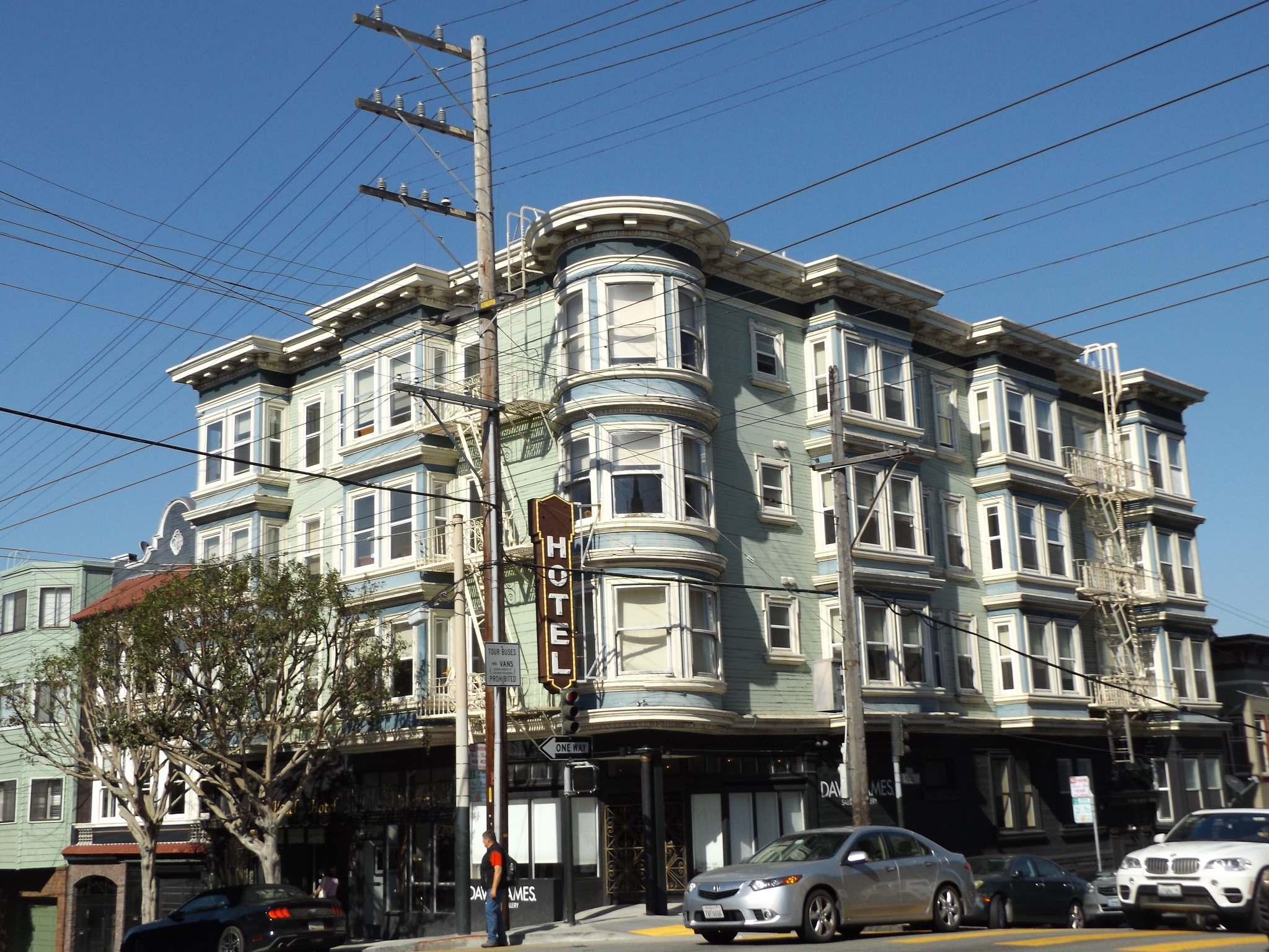
At the same time as booking my flight, I booked a relatively inexpensive hotel in the western suburbs, Casa Loma, for the first four nights. I decided to stay at another hotel near to Fisherman’s Wharf, San Remo, for the last four nights of my trip. Hotel accommodation in San Francisco is expensive, and neither room offered en suite facilities, exterior windows or breakfast included in the price.
Day 1
It was an exceptionally bright, sunny morning as I left the Renaissance Hotel to catch the bus through the underpass to Heathrow Airport’s Central Bus Station. Three hours later, the plane took off for the 10-hour journey to San Francisco. It was far from full, and I had a row of three seats in between the two aisles to myself.
Surprisingly, the flight followed a northerly route over Iceland, Greenland and down the northwest side of Hudson Bay. The weather forecast for San Francisco was excellent, and as the plane began its descent the cabin crew announced that passengers on one side of the plane could expect a spectacular view of the Golden Gate Bridge. However, as we descended through the clouds, the bridge and the city were enshrouded in mist, so there was nothing to be seen.
When the plane landed, the airport was basking in bright sunshine, but steamy clouds obscured the surrounding mountains. The airport is about 13 miles (21 km) south of San Francisco on the eastern side of the peninsula beside San Francisco Bay. The surrounding area is surprisingly built up, at the northern end of the densely-populated Silicon Valley, which stretches from San Francisco down to San José. A spine of mountains along the peninsula separates Silicon Valley from the more rural west coast with its quiet fishing towns.
Passing through immigration control and the baggage carousels far more quickly than I expected, I arrived at the Bay Area Rapid Transit (BART) platform barely 20 minutes after touchdown. The BART is operated by rather aged, London Underground-style trains, but it is a fast and efficient way of getting around the northern San Francisco Bay area. The train ran underground for the first few stops, before emerging at Daly City, which was cloaked in a bleak fog. With its densely-packed houses stacked in terraces up steep hillsides, Daly City looked more like an industrial town in central Scotland or the Welsh valleys than the sunny California depicted in the movies.
My hotel was close to Alamo Square, a couple of miles west of Downtown San Francisco, so I had a choice of getting off at 16th Street Mission or Civic Center BART stations, both of which were described as unsafe areas at night. As I had left the airport much earlier than expected, and there were still several hours until nightfall, I decided to get off the train at 16th Street Mission and to walk the mile and a half to the hotel. The plaza above the station was seedy and crowded with homeless people and drunks, but after walking a short distance I reached a more prosperous neighbourhood which felt much safer. The sun was now shining, as it often does in the Mission District when other parts of the city are covered in fog. It didn’t take long to reach the hotel, which was situated in a residential area on a gently sloping hill to the west of Downtown.
The Casa Loma Hotel, like much of the neighbourhood, was a wooden Victorian-style building. The facilities were basic, with shared toilets and showers, but it was conveniently located for public transport, reasonably quiet and in a safe area.
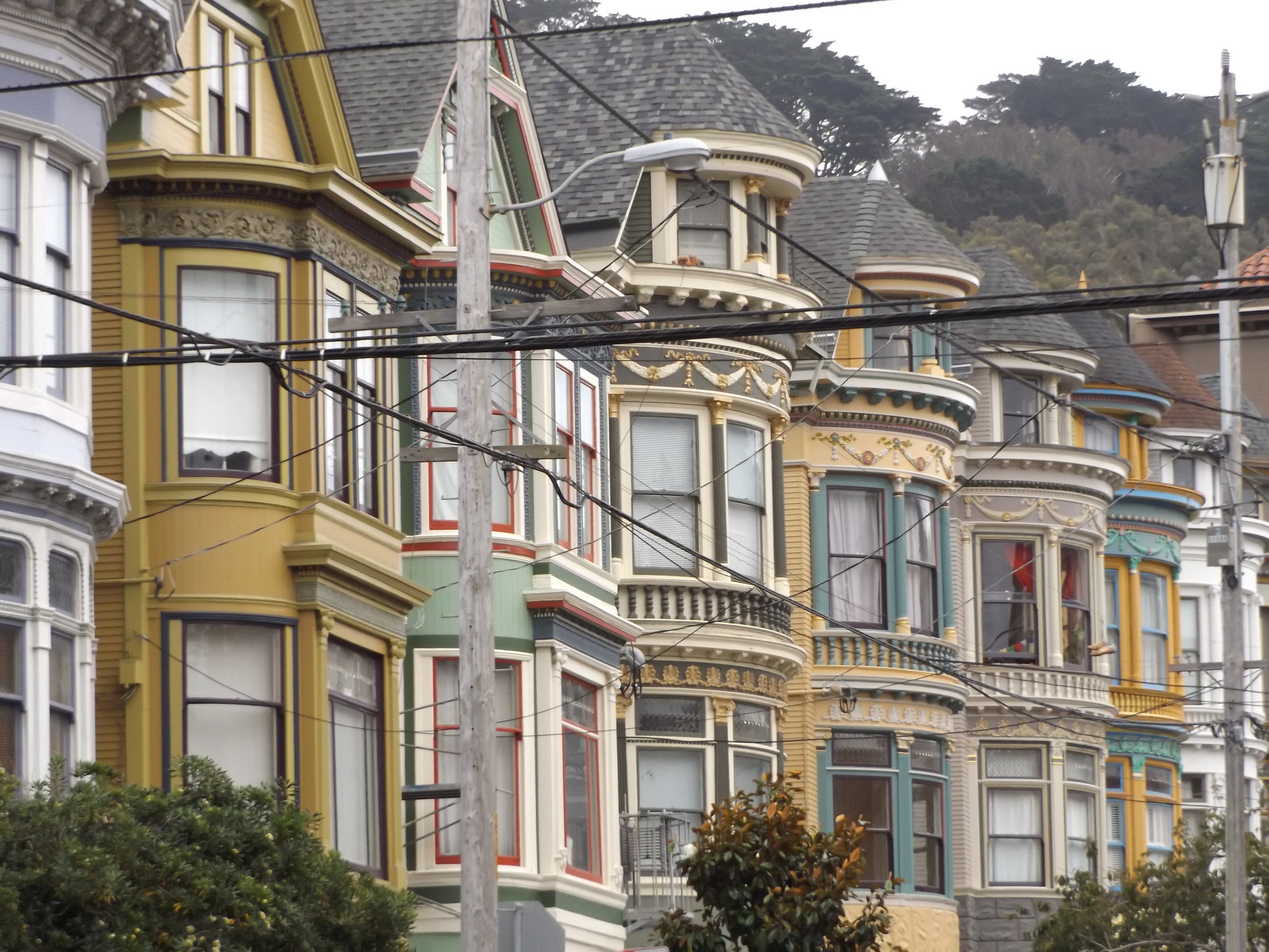
After checking into the hotel at around 5 pm, I went out to buy some food and drink from the nearby Safeway supermarket, which I had passed on the way from the BART station. En route to the supermarket, I walked up to Alamo Square, with its famous row of Victorian houses, known as the “Painted Ladies”. Disappointingly, the sky had turned grey and gloomy again, but even so, the square was packed with tourists and photographers.
The Safeway supermarket on Market Street is probably the largest in the city, with its huge Art Deco sign towering over a busy road junction. Situated close to San Francisco’s main gay and lesbian district, the Castro, it is described by one guidebook as “one of the most cruisey grocery stores in the country for members of all sexes and orientations”. As with other shopping areas of San Francisco, there were quite a few homeless people hanging around the tram and bus stops in the surrounding streets. Entering the store, I was surprised to see how upmarket it was, resembling the food court of a posh department store. Navigating the supermarket’s long aisles was quite difficult, as the range of products and the store layout were quite unlike British and European supermarkets. Everything seemed incredibly expensive, perhaps even more so than the Faroe Islands.
Day 2: Golden Gate Park
The following morning, it was grey, gloomy and cold, but I decided to set out early to walk through Golden Gate Park to the coast. A couple of blocks to the south of my hotel was Haight Street, which ran westwards through the famous Haight-Ashbury district to the Golden Gate Park. Lower Haight is a pleasant neighbourhood with shops, cafés and some striking Victorian houses. Further up the hill to the west, Haight-Ashbury is a rather seedy area with many homeless people and drunks. It seemed especially bleak on a chilly, grey morning when most of the shops had not yet opened. Haight Street’s many “alternative” shops selling sex accessories, tattoos and piercings, and a huge pair of legs with fishnet stockings dangling from an upstairs window added to the impression of seediness.
Surprisingly, the streets leading off Haight Street to the north and south were much more gentrified, with their large, ornate, smart-looking Victorian villas. Turning north along one of these streets, I immediately reached the Panhandle, a long, narrow park running east-west between Fell and Oak Streets. From here, it was just short walk to the entrance to Golden Gate Park.
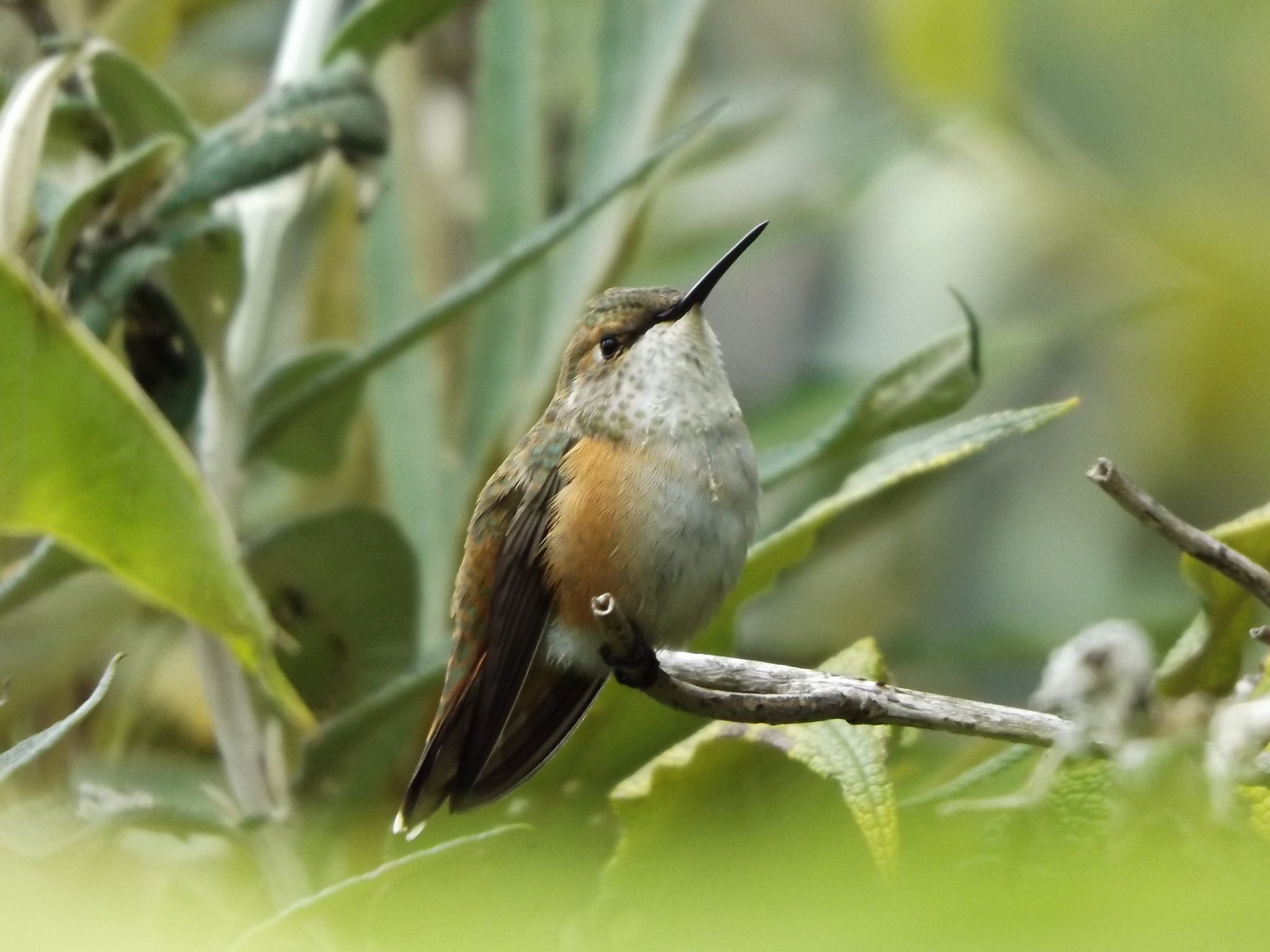
The park’s main driveway, John F Kennedy Drive, is lined with dense woodlands that are a good place to spot birds. North America lies in a different faunal region – the Nearctic – from Europe and Asia, and many of the species found to the west of the Rockies are different from those found in Eastern North America. This made it easy to tick off new species that I had not seen before, including dark-eyed junco, California towhee, white-crowned sparrow, song sparrow, chestnut-backed chickadee, pygmy nuthatch, Nuttall’s woodpecker, Pacific slope flycatcher, Steller’s jay, Anna’s hummingbird and a pied-billed grebe on Stow Lake.
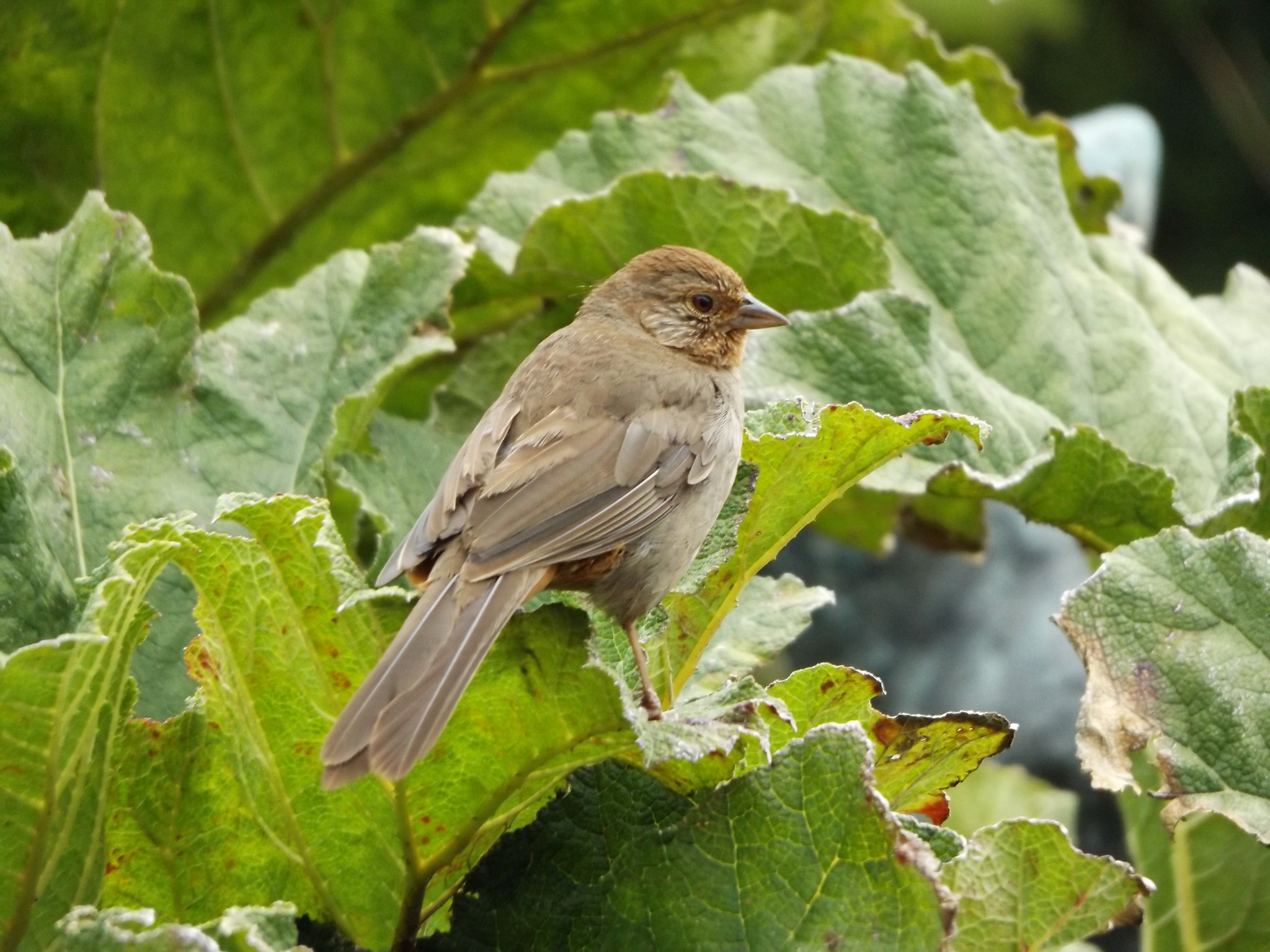
California towhee
I emerged from the woodland by the Conservatory of Flowers, where there was a garden full of brightly-coloured dahlias. Further along John F Kennedy Drive, I arrived at the “Music Concourse”, the large central plaza in front of the De Young Museum. In a secluded spot just beyond the museum is the Japanese Tea Garden, which is free to enter before 10 a.m. It is the oldest public Japanese garden in the United States, originating in a “Japanese village” exhibit at the 1894 California Midwinter International Exposition.
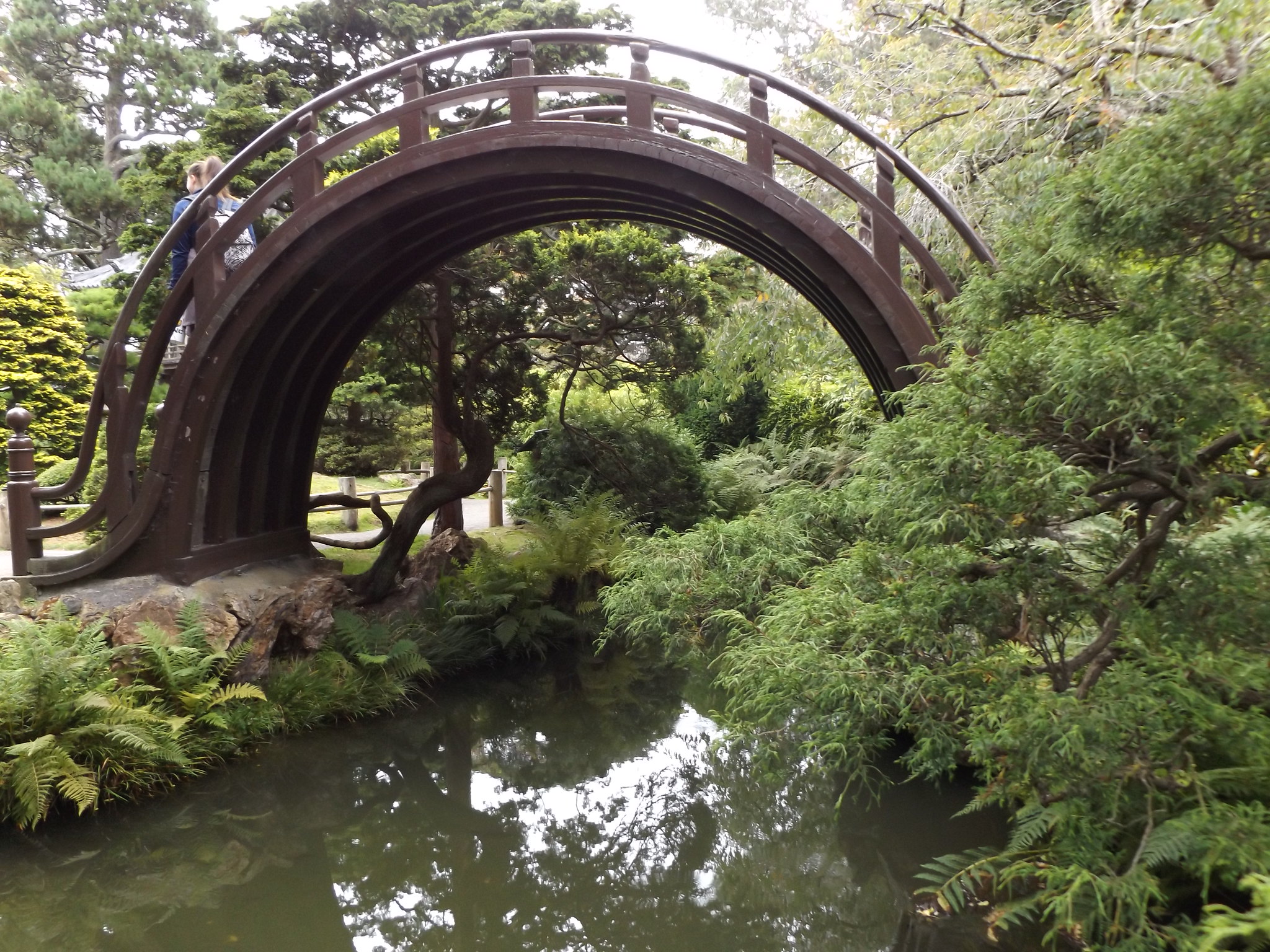
The Japanese Tea Garden is one of the most popular attractions in Golden Gate Park, and was already quite busy when I arrived, even though it was not long after 9 am. Even so, it was an atmospheric spot, with its lush Japanese shrubs and trees, winding paths, stone lanterns and ponds. The garden owes much of its present layout to the Japanese immigrant landscape gardener Makoto Hagiwara, who was tasked with converting the 1894 exhibit into a permanent Japanese garden, and served as its caretaker from 1895 until his death in 1925. After Hagiwara’s death, the property was looked after by his daughter, until she and her family were forced to move into an internment camp in 1942. Anti-Japanese sentiment during World War II resulted in the garden being renamed the “Oriental Tea Garden”, references to Japanese culture being removed, and Chinese women in traditional dress being brought in as tea servers. The garden’s Japanese identity was eventually reinstated in 1952. Its most interesting sights include a tea house, a rock garden, a rather dilapidated five-storey pagoda dating from 1915, a waterfall and a pond with huge koi carp. Perhaps the most striking feature is the drum bridge (taiko bashi), also known as the moon bridge, because of its almost semi-circular shape with steep wooden steps up to the top.
Continuing through Golden Gate Park, I arrived at Stow Lake on the northern side of the park. Constructed in 1893, the lake has a Chinese pavilion, cafés, boathouses hiring out electric, paddle and rowing boats, and plenty of water birds.
A busy highway, Cross Over Drive, separates the eastern and western halves of Golden Gate Park. I continued into the quieter western section of the park, with its vast acres of secluded woodlands. The ground beneath the trees was almost entirely sand; much of this western side of the peninsula, as far inland as Haight-Ashbury, was once coastal sand dunes. Stretching for over three miles from west to east, the park was designed by William Hall in 1871, imitating the style of Central Park in New York. A dyke was built at the western end to protect the park from the Pacific Ocean, and thousands of trees were planted on what had previously been sand dunes.
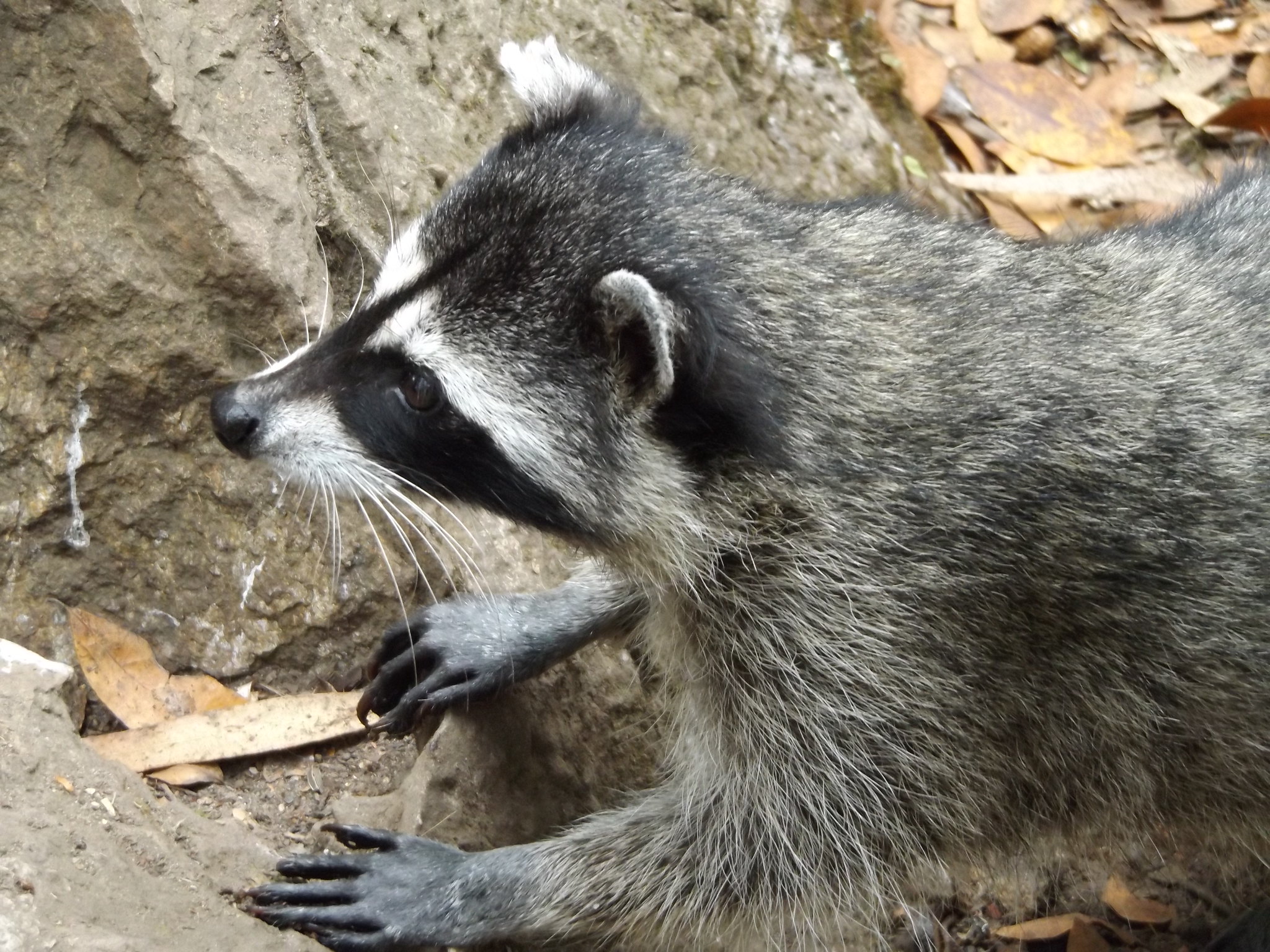
Walking along the narrow path alongside the Chain of Lakes, I was suddenly startled by a loud growl coming from the bushes and expected to be mauled by a vicious big dog at any moment. Instead, three small raccoons came bounding out of the bushes at the edge of the lake on to the path. Two of the raccoons quickly darted into the undergrowth, while the third stayed around for a while, searching for food and eventually finding a nut on the path close to my feet. It was interesting to watch its cautious movements, with its rather short, delicate front legs and dexterous paws.
I suddenly became aware of the sound of crashing waves, and realised that I had reached the end of the park at the Pacific coast. Crossing the Great Highway, I walked along the bleak, windy seafront towards Land’s End. Just offshore were the jagged outlines of Seal Rocks, stained white with guano, and dotted with pelagic cormorants and much larger brown pelicans. The road ascended to the Cliff House on a rocky bluff overlooking the ruined Sutro Baths, once a large saltwater swimming pool complex which was destroyed by fire in 1966. From here, the path along the coast turned eastwards, giving me my first rather bleak, misty view of the Golden Gate Bridge. A path through dense woodland wound its way uphill to the Museum of the Legion of Honor.
Founded by Alma Spreckels, the wife of a wealthy sugar magnate, the Legion of Honor is San Francisco’s leading museum of European art. Prominently located on a hill top overlooking Lincoln Park, the rather austere neoclassical building with its courtyard of Corinthian columns was modelled on the Palais de la Légion d’Honneur in Paris. It featured in Alfred Hitchcock’s film Vertigo, in which retired detective Scottie (James Stewart) is hired by an old college acquaintance to spy on his wife, Madeleine (Kim Novak). Scottie finds Madeleine sitting in one of the museum’s galleries, staring at a painting of a woman called “Carlotta”, who is then the subject of further investigations by Scottie as he becomes more and more entranced by Madeleine. In reality, the museum has about 250 paintings on display, representing European art from the 14th to the 20th centuries, including works by Rubens, Van Dyck, Rembrandt, El Greco, Delacroix, Degas, Manet and Monet.
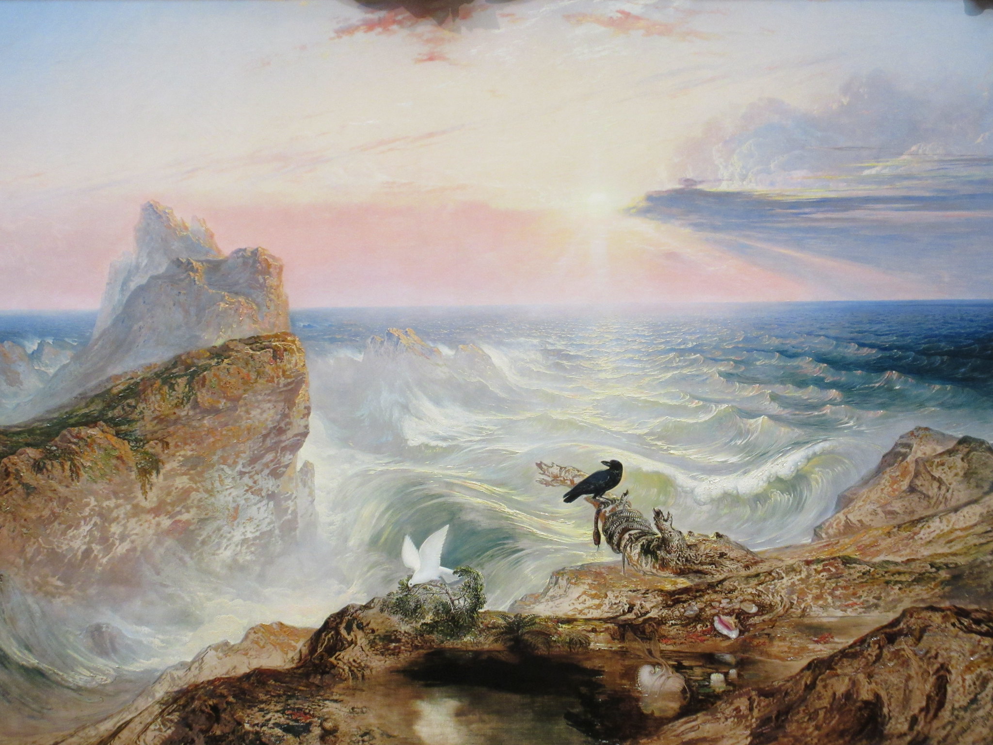
This painting by John Martin (1789-1854), “The Assuaging of the Waters”, seems to capture the dramatic coastal landscape of Land’s End and Seal Rocks just outside the museum, although the artist was in fact based in London and spent his last days on the Isle of Man.
After looking around the museum, I walked back through the Richmond district to Golden Gate Park. The Buffalo Paddock was a bit of a disappointment, with its distant views of two rather sad-looking bison, so I carried on, passing an open grassy area where large family groups had gathered to celebrate Labor Day in spite of the rather gloomy weather. Eventually, I found a spot by a large artificial waterfall to sit down for a drink and a snack.
Walking around the southern shore of Stow Lake, I reached the south-eastern corner of the park, below Mount Sutro with its mist-cloaked eucalyptus forest. Just across the road from the park gates, in the Inner Sunset district, there was a lively shopping street with plenty of restaurants. I stopped for an early evening meal at an inexpensive restaurant called Lemonade, which offered a salad buffet and various flavours of still lemonade. From there, I had a two-mile walk through Haight-Ashbury back to the hotel.
In the evening, I walked down the hill to the Civic Center to look at the floodlit City Hall, which seemed to be lit up in different colours on different nights.
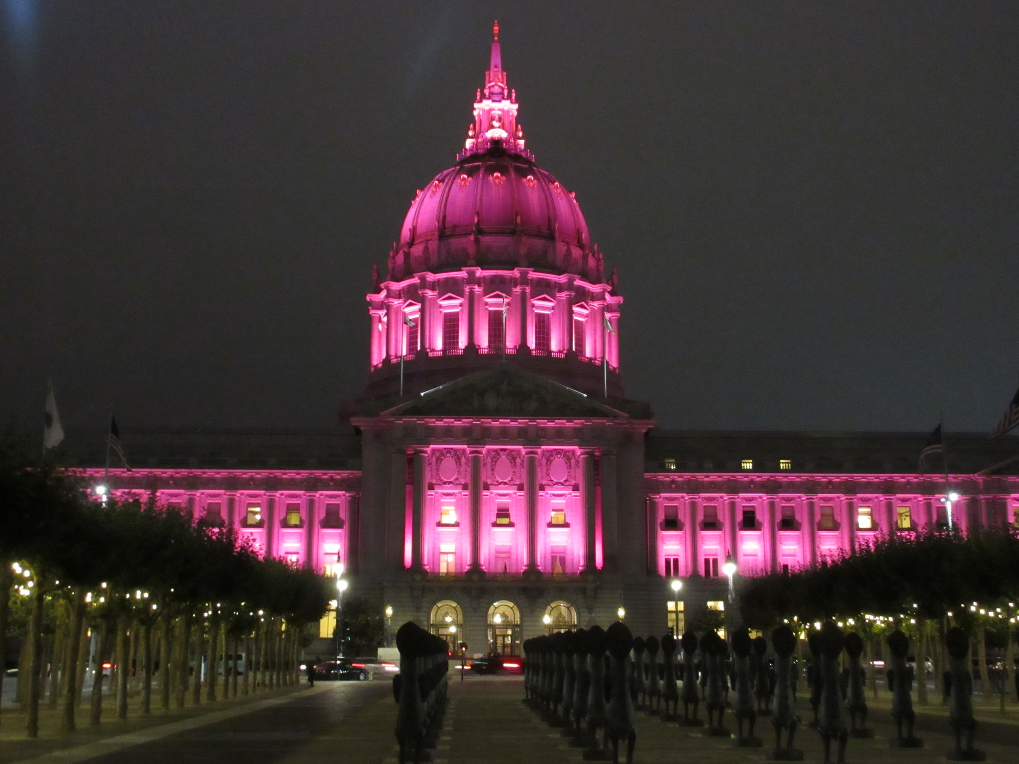
Sadly, the large open area to the east of the City Hall, together with the nearby stretch of Market Street, was heavily frequented by homeless people and was not a comfortable place to linger at night.
Day 3: Half Moon Bay and Montara
My plan for Tuesday was to travel down the coast to Half Moon Bay, which involved taking the BART to Daly City and then taking two buses. It was a cold, grey morning as I left the hotel to walk down to 16th Street Mission Station. Dodging the crowds of homeless people around the station entrance, I bought a ticket and boarded a train for the short journey to Daly City.
Once again, Daly City was enveloped in a dense, bleak fog. At the adjoining bus interchange, I had to wait a long time for the 110 bus to Linda Mar. An elderly, east Asian woman, who obviously spoke no English and could not read the Latin alphabet, was brandishing a piece of paper with an address in Redwood City that she was trying to get to by bus. She boarded various buses, as drivers and passengers patiently tried to explain that they were not going anywhere near Redwood City, but she never once approached any of the frequent ECR (“El Camino Real”) buses which did go there. Eventually, the 110 bus arrived, and after the driver had spent some time trying to explain to the elderly lady that he was not going to Redwood City, the bus eventually set off with only a few passengers on board.
Leaving Daly City, the bus slowly began to ascend a long road of identical bungalows with drab gardens and few trees or shrubs to break the monotony of the fog. Approaching Pacifica, the bus turned into a housing estate with impossibly steep, straight roads and right-angled road junctions which made no allowance for the steep topography. In such challenging driving conditions, it was perhaps understandable that the driver forgot his route, and after emerging from the housing estate turned back towards Daly City instead of continuing on towards Pacifica and Linda Mar. One passenger anxiously stopped the bus and got off, thinking that she had boarded the wrong bus. Eventually, realising his error, the driver turned around, picked up the passenger who had got off, and continued on his way towards Linda Mar. The bus was now 10 minutes late, and I was worried that I would miss my tight connection at Linda Mar.
As the bus sped towards Linda Mar, the fog suddenly gave way to blue sky and sunshine. Linda Mar Park & Ride had sounded like a bleak bus interchange in the middle of nowhere, but in fact it was a pleasant small town situated in a coastal valley encircled by forest-clad mountains. Like the Mission District, Linda Mar has a sunnier climate than other nearby parts of the San Francisco peninsula, protected from the coastal fog by its topography.
Within a few minutes, the hourly 17 bus to Half Moon Bay arrived. The local bus operator in San Mateo County, SamTrans, offers a very cheap one-day bus pass covering its entire network. As the bus approached the road tunnel which was built to bypass the notoriously unstable section of Highway 1 known as the Devil’s Slide, the scenery was bathed in bright sunshine, but a dense wall of cloud hung over the mountains ahead. Emerging from the tunnel into gloom and fog, the bus made a detour through the forested back roads of Montara, before rejoining the main road and continuing down the coast to Half Moon Bay.

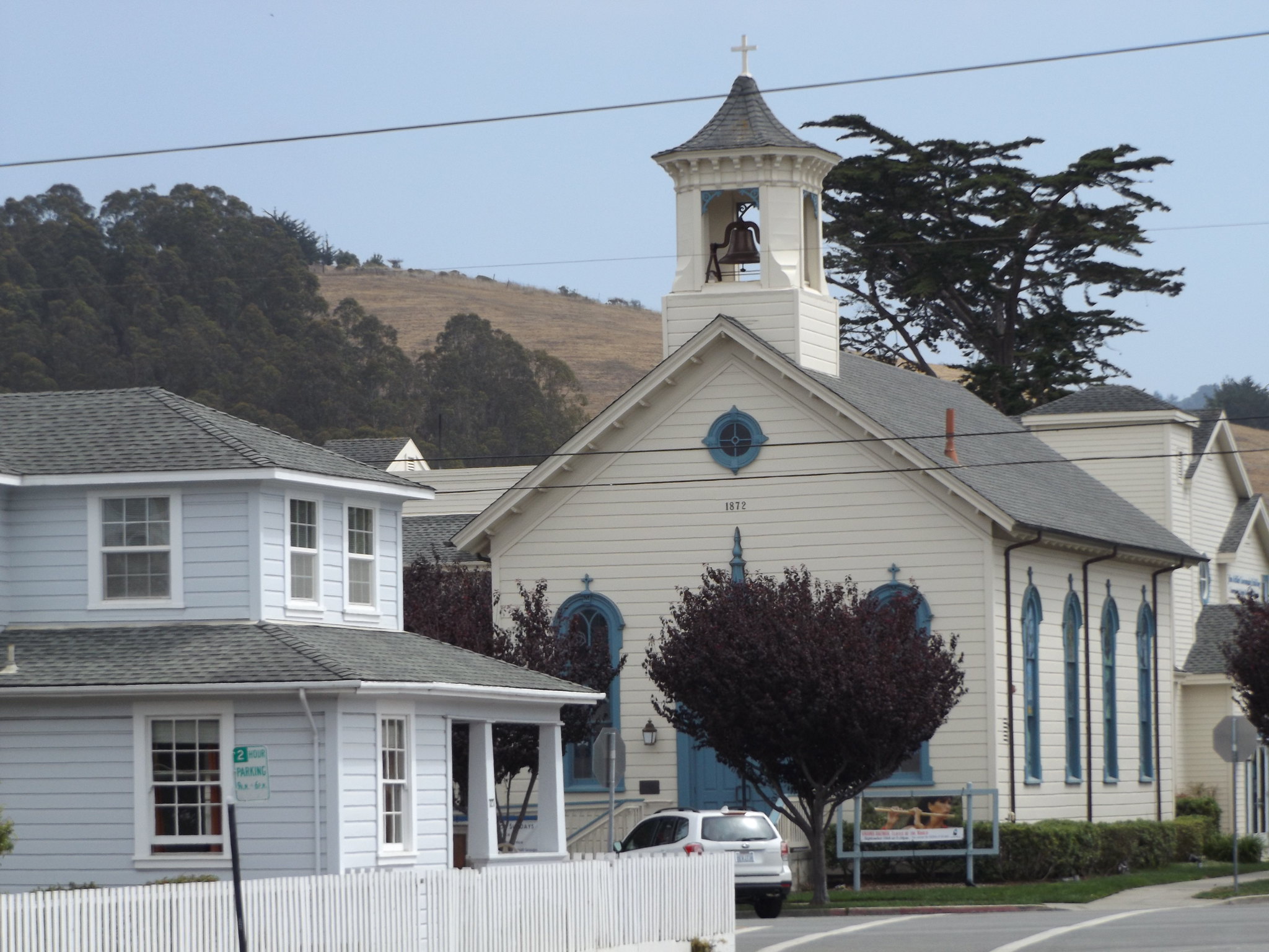
Half Moon Bay is a small town about a mile inland from its beach, built on a grid pattern with a single shopping street. It is a quiet place, with little to see on Main Street, apart from a handful of shops and cafés. Anna’s hummingbirds hover among the trees lining Main Street, making their distinctive twittering calls. The town’s spacious side streets are lined with old wooden houses, as well as an attractive Methodist Episcopalian Church dated 1872 and the Old Jail from 1911.
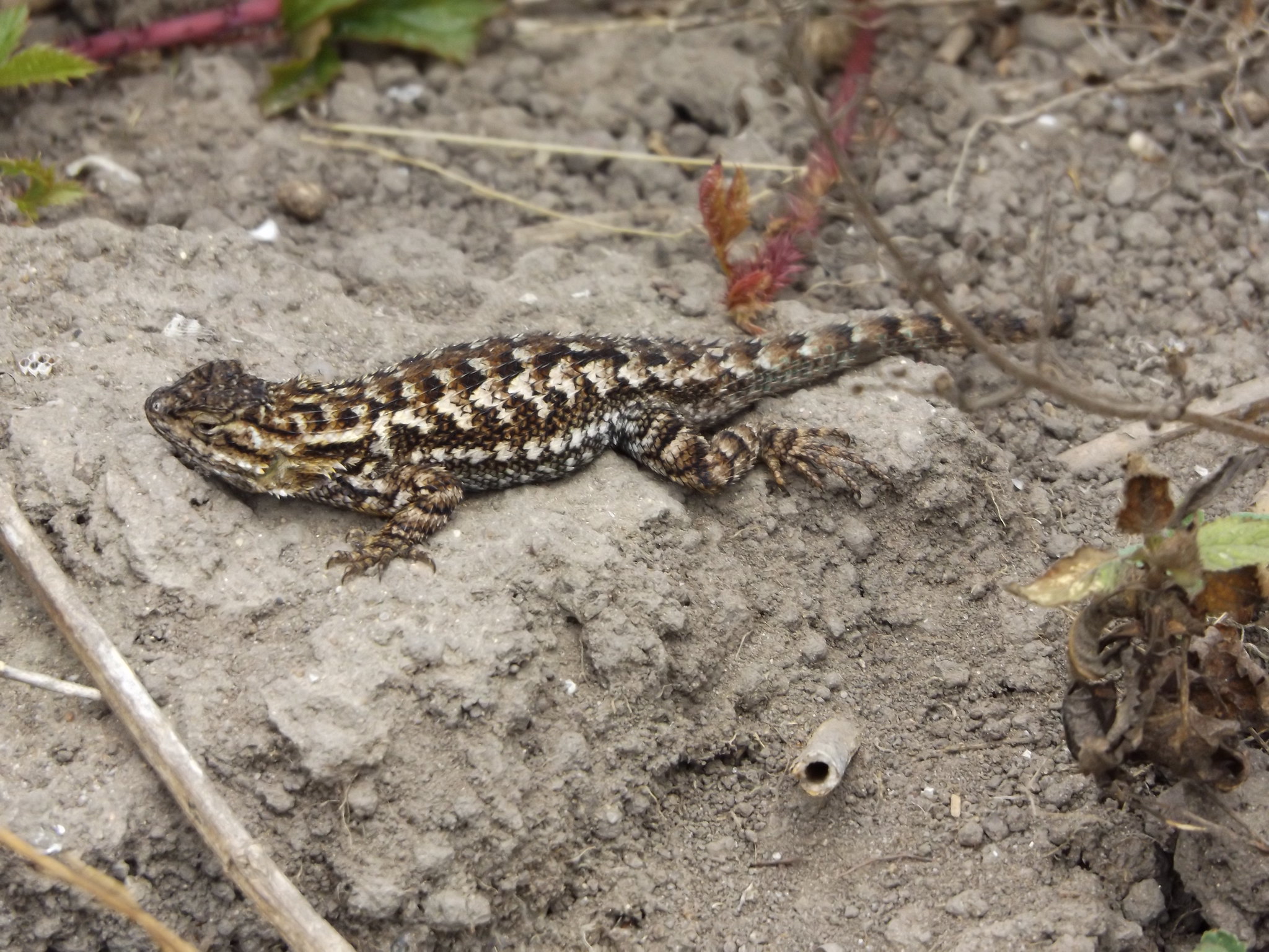
By midday, the sky began to brighten up, although it was still overcast. I caught a 17 bus back up the coast to Princeton-by-the-Sea, arriving just as the sun came out. Buying a drink at a local store, I walked across to Pillar Point Harbour, where there were large numbers of elegant terns diving into the water. Along the harbour’s main pier, I saw a California sea lion in the water and another one sitting on one of the jetties. Further around the bay, at Pillar Point Bluff, there is a nature reserve with walking trails leading northwards towards the Fitzgerald Marine Reserve. Fence lizards, small relatives of iguanas, scuttled across the path as I headed towards the reserve.
The Fitzgerald Marine Reserve is a well-known spot for finding all kinds of marine life among the rockpools, but unfortunately, by the time I arrived, the tide was coming in rapidly, leaving only a narrow strip of sandy beach above water. There was little to see apart from a lone turkey vulture pecking at some debris at the water’s edge, so I didn’t stay long before catching another bus for the short journey north to the Devil’s Slide.
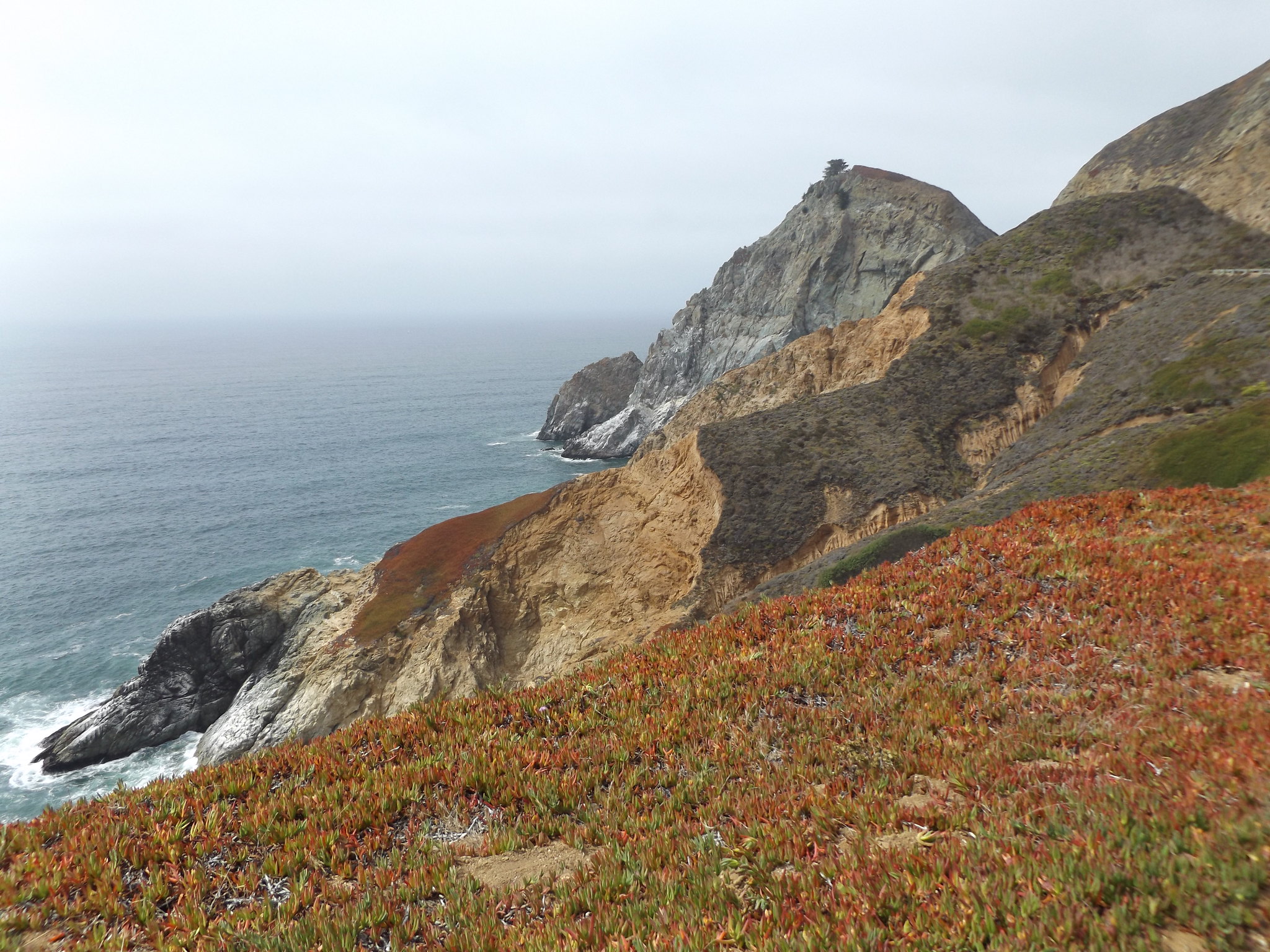
The Devil’s Slide is a particularly dramatic coastal headland between Linda Mar and Montara. From 1936 until 2013, a narrow, winding section of Highway 1 hugged the steep promontory, prone to frequent closures because of landslides and erosion. Following the discovery of major cracks in the road in 2006, resulting in the closure of the road for several months, local people successfully lobbied for a new road tunnel to be built through the mountains, inland from the Devil’s Slide. Approximately $2 million was spent converting the old road into a new trail for pedestrians and cyclists. The Devil’s Slide has an interesting military history as a World War II triangulation station and observation post, and is also an important location for geology and botany. Leaflets and interpretation boards along the trail explain the features of interest.
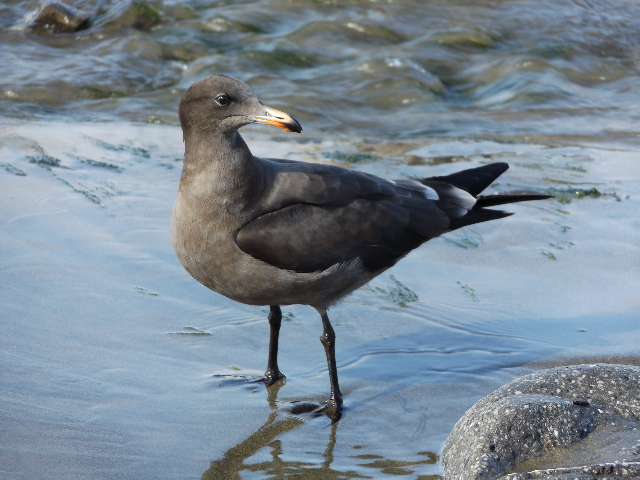
There are small car parks at both ends of the trail, but pedestrian and bus access is only available from the southern end. It isn’t safe to walk down the main road from the northern end of the trail into Linda Mar, but I discovered a footpath through the woods below Pedro Point headland, which rejoined the main road next to a retail park. There was a large supermarket, which was much cheaper than the ones in San Francisco. Taking the opportunity to stock up on food and drink, I walked down to the beach. Once again, Linda Mar was bathed in bright sunshine. The beach was busy with surfers riding the crashing ocean waves, and handsome Heermann’s gulls, with their charcoal-grey plumage and reddish bills, stood in huddles all along the beach.
When I got back to the BART station in Daly City, the sky was still murky. I decided to get off the BART at 24th Street Mission station at the southern end of the Mission district, giving me the opportunity to explore this colourful, predominantly Latino neighbourhood of San Francisco.

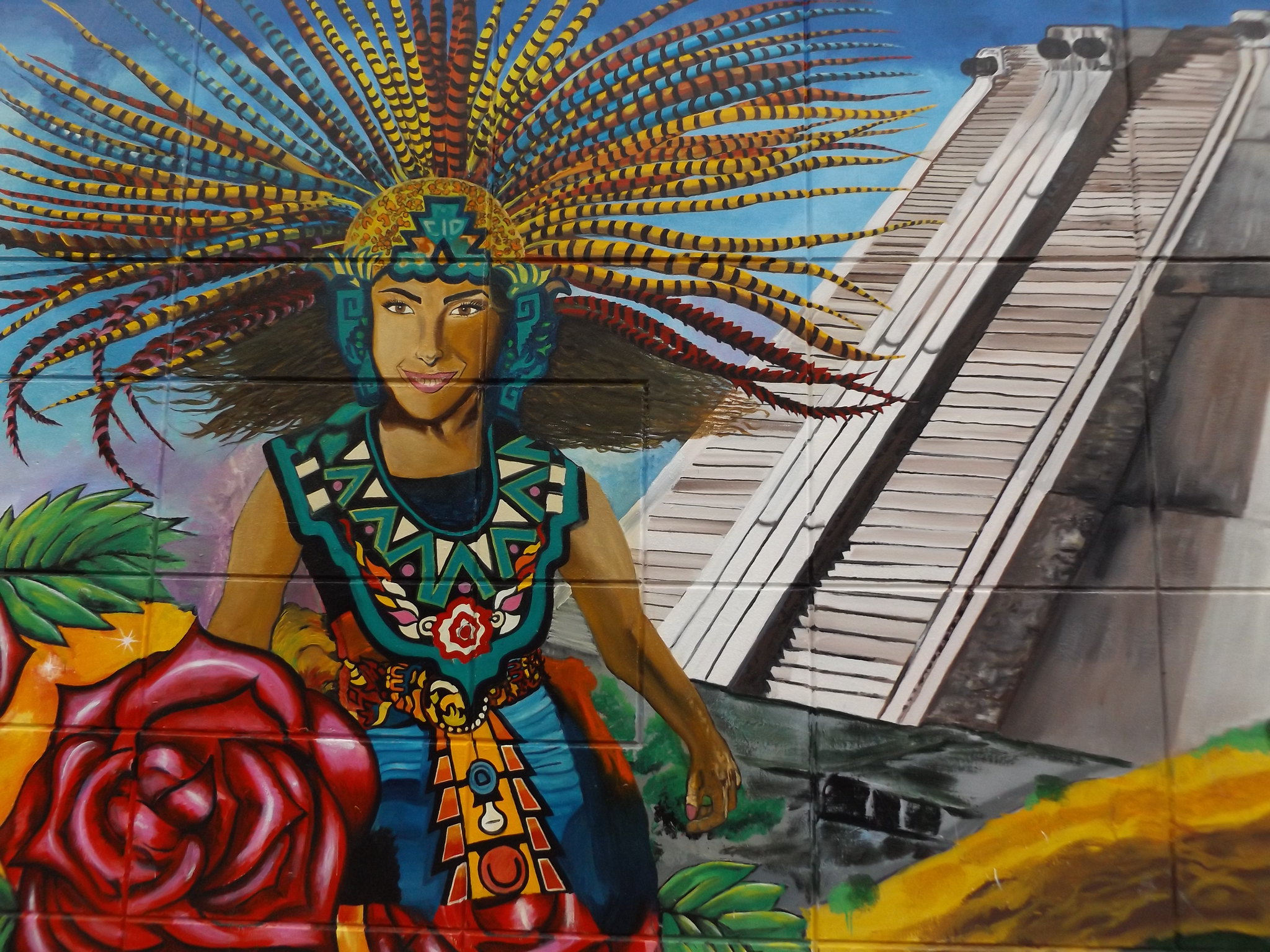
The Mission is famous for its hundreds of murals, some of which celebrate Latin American culture, while others are more overtly political. Most of the murals are in the side streets and back alleys off Mission Street, the long, straight thoroughfare running north-south through the district. Some of the murals attract controversy and sadly, some of the better ones are defaced by graffiti. It is quite common for murals to be painted over with new ones after only a few years; I found it quite difficult to locate some of the murals I had seen on Google Street View, as they had only recently painted over the previous ones.
Day 4: Berkeley and Oakland
I had planned to spend Wednesday exploring the East Bay. Disappointingly, it was yet another cold, gloomy morning as I caught the 21 bus towards the Ferry Building, but I was hoping that the weather might improve when I crossed over to the East Bay, which is well-known for having a much warmer climate than San Francisco.
Completed in 1898, the pale-blue Ferry Building with its 75-metre high clock tower stands proudly at the north-eastern end of San Francisco’s main thoroughfare, the ruler-straight Market Street. In the late 1950s, a monstrous elevated roadway was built right in front of the building’s façade, obscuring it from Market Street. With the construction of bridges over San Francisco Bay, ferry traffic declined and the Ferry Building was converted unsympathetically into offices. Following the partial collapse of the elevated freeway in the 1989 Loma Prieta earthquake, it was decided that the freeway should be dismantled entirely and replaced with a tree-lined boulevard at ground level. Removal of the freeway was completed by 1992 and plans to convert the Ferry Building into an upmarket shopping and restaurant space were drawn up. Now fully refurbished, the building has an attractive interior with smart shops and eateries, although it has little connection with the ferries that still depart from the piers behind it, with the exception of a small kiosk selling ferry tickets.

The ferry journey to Oakland took 25 minutes, passing under the San Francisco Bay Bridge. The views would have been spectacular in better weather. Entering the Oakland Estuary and passing the massive Port of Oakland cranes, the ferry docked at a jetty in front of the Jack London Square waterfront complex. Setting off through the uninspiring grid of streets behind Jack London Square, I walked under the elevated freeway towards Downtown Oakland. As the weather was showing no signs of brightening up and it was still very cold, I thought about visiting Oakland’s Museum, but as it didn’t open until 11 am, I decided to go straight to Berkeley.
The No. 6 AC Transit bus took about half an hour to get to Downtown Berkeley, travelling along the ruler-straight Telegraph Avenue through a predominantly Korean district followed by a long stretch of nondescript suburbia. The Berkeley end of Telegraph Avenue was rather tacky, and the downtown itself was uninspiring, with no real central shopping area. I bought a drink and a snack at CVS Pharmacy and set off through the University campus and up the winding road to the Botanical Garden.
Nestling in a valley surrounded by high, forest-covered hills, the Botanical Garden would have been a picturesque spot on a nice day, but it was still cold and the hills were shrouded in fog. It was the one day of the month when entry was free, and the garden was fairly busy. I wandered along the meandering paths through the garden, dodging the revolving water sprinklers, which seemed excessive in such cool weather. I spent quite a long time trying to get a photograph of the many Allen’s Hummingbirds which could be seen darting from tree to tree.
After exploring the gardens alone for a while, I joined a tour given by a volunteer guide (or “docent”, as they are known in the USA), who was very informative, despite not being a professional botanist. On such a bleak, misty day it was strange to see so many cactuses, cycads and palms growing outdoors; northern California normally has a Mediterranean climate, and the East Bay is generally much warmer and sunnier than the San Francisco Peninsula.
On the way back down the hill, I was surprised to see a group of wild turkeys grazing by the roadside. Turkeys are native to North America, and the wild ones are much slimmer than their domesticated relatives.

Arriving back at the University campus, I headed for Sather Tower, which is the World’s second tallest freestanding clock tower after the Joseph Chamberlain Memorial Clock Tower at Birmingham University. The tower is named after Peder Sæther, a Norwegian-born banker whose legacy to the University of California funded the tower (known as the Campanile), the Sather Gate, a visiting professorship in Classics and an international symposium. Visitors can ascend the 94-metre tower via a lift to an observation platform just below the 61-bell carillon. There are impressive views over the University campus, along Telegraph Avenue to Downtown Oakland, and across the bay to the skyscrapers of San Francisco.
From the observation platform, I could see that the sky was starting to brighten up from the Oakland direction, although it was still very gloomy over San Francisco.
Almost as soon as I had descended the Campanile, the clouds cleared, giving way to a bright, sunny afternoon. I caught a bus back to Oakland, which looked much more appealing in bright sunshine, resembling a miniature Manhattan with its early 20th century skyscrapers and flatiron buildings.
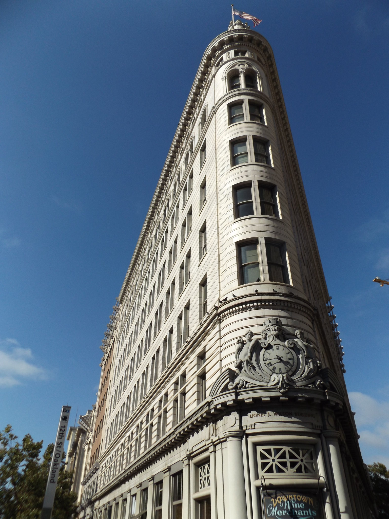
The first European settlers to arrive in the Oakland area were the Spanish in 1772, but development of the present Downtown area began in the 1850s. Oakland rapidly became one of the west coast’s busiest ports with the construction of docks and railroads in the 1860s and 70s. The city expanded massively after the San Francisco earthquake of 1906. Oakland’s most impressive landmarks include the Bank of America Building from 1907, the Gothic revival Federal Realty Building and the City Hall, both completed in 1914, and the Tribune Tower from 1924. One of the most striking flatiron buildings is the Beaux Arts-style First National Bank Building (also known as the Lionel Wilson Building), completed in 1908, which stands at the junction of Broadway and Frank H. Ogawa Plaza.
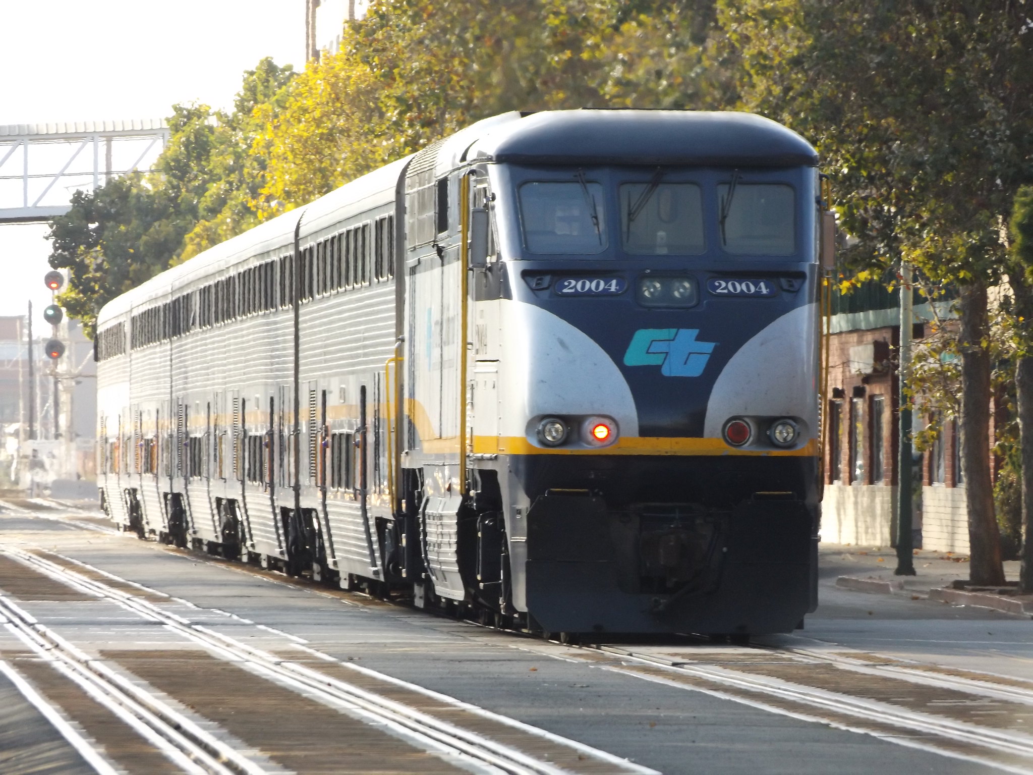
Another unusual sight is the Amtrak railway which runs along the street beside Jack London Square, where the city’s main railway station is located. In addition to freight trains, there is a frequent passenger service along the “Capital Corridor” linking San José to the south with Sacramento to the north-east.
After stopping to watching the passing trains for a while, I boarded Oakland’s free shuttle bus back to the north end of Downtown. Walking the short distance to Lake Merritt, I picked up the NL bus back to San Francisco.
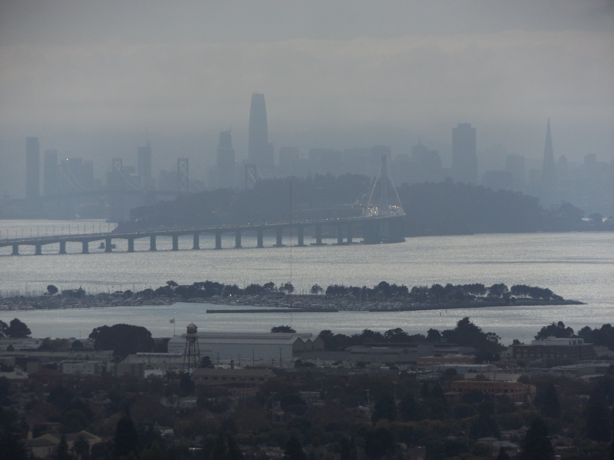
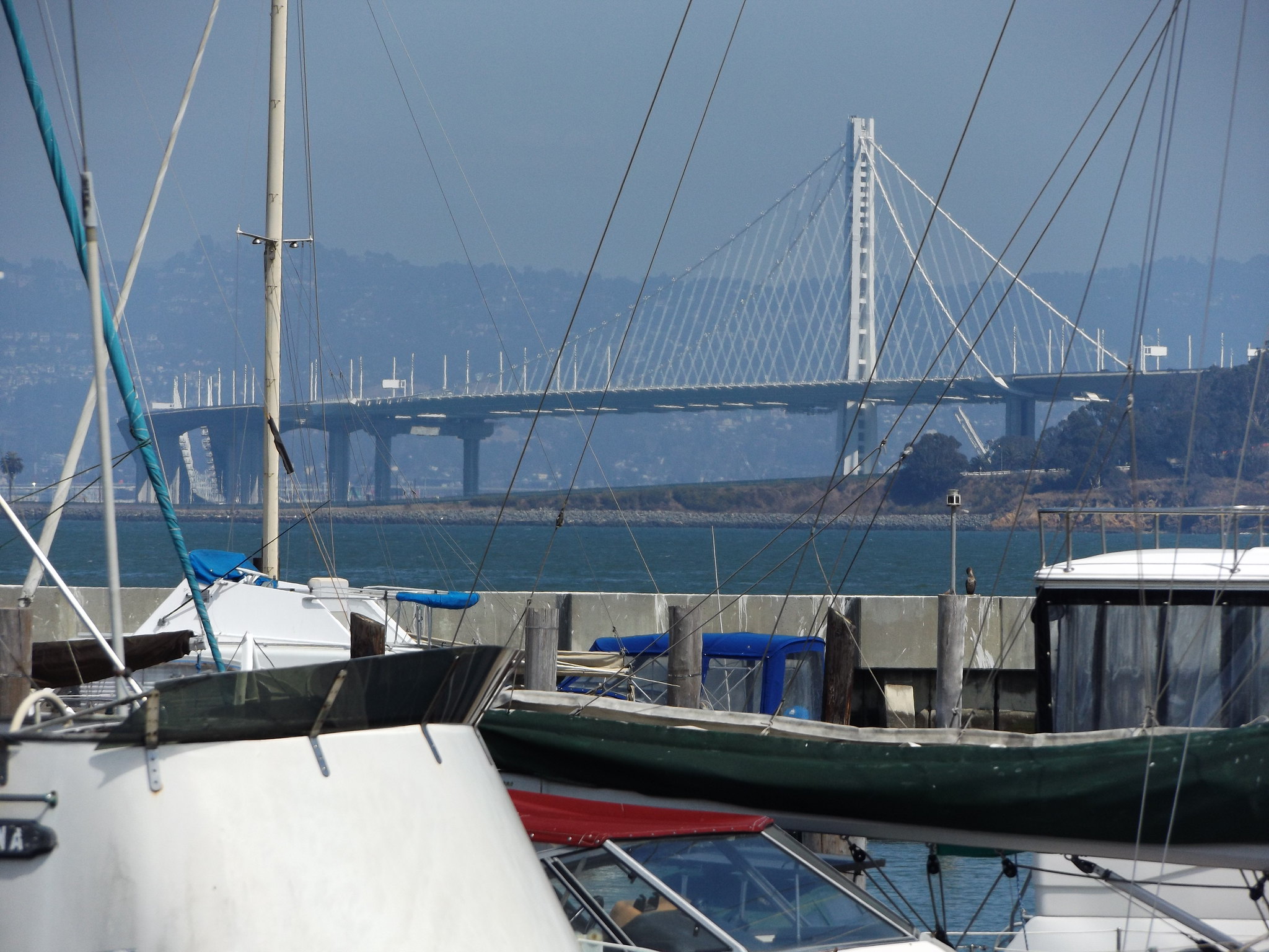
Several AC Transit bus routes from Alameda County travel over the Bay Bridge to San Francisco’s Salesforce Transit Center, and the ride is well worth it for the spectacular view of the skyscrapers of Downtown on the approach to the city. The “Bay Bridge” is actually two separate bridges, linking West Oakland and Downtown San Francisco via Yerba Buena Island. The west bridge, a double suspension bridge with two vehicle decks, was in fact completed a year before the Golden Gate Bridge, in 1936. The section east of Yerba Buena Island was originally a cantilever bridge, but a new suspension bridge was completed in 2013, after which the cantilever bridge was dismantled. The new suspension bridge carries ten lanes of traffic on a single deck, making it the world’s widest bridge, with a width of nearly 79 metres.
As the bus sped along the west Bay Bridge towards San Francisco, a menacing wall of dark cloud loomed over the city. A complicated network of elevated sliproads weaved their way between tower blocks to the entrance to the new Salesforce Transit Center. Leaving the bus terminal, I bought some food and headed back to the hotel.
For the second half of my trip, I relocated to another hotel nearer to the main tourist attractions. The promised sunny weather finally arrived. The last five days of my trip will be covered in another post.

4 thoughts on “San Francisco – Part 1”