Visited on: Thursday 12 – Thursday 19 July 2018
Having visited every other Nordic country, and inspired by a trip to the Shetland Islands in 2016, I decided that the Faroe Islands would be a logical choice for my next holiday in Summer 2018. I had booked a trip to San Francisco, my first visit to the United States, almost a year in advance, but that trip was still many months away and I was keen to go somewhere interesting in the meantime. Discovering that flights to the Faroes from Edinburgh with Atlantic Airways were relatively cheap, I eagerly booked a ticket without having investigated accommodation and other arrangements.
I thought about camping, but was put off by ominous warnings about the islands’ notoriously strong winds which often resulted in campers returning from a day’s sightseeing to find their tent floating on the sea. In the end, I opted for the Guesthouse Marknagil, which offered basic accommodation on the outskirts of town with the advantage of a hot and cold buffet breakfast.
As the flight from Edinburgh was in the early afternoon, I had to travel up by train the day before and stay in the city overnight. I arrived in Edinburgh on a warm, sunny afternoon at the height of the tourist season. I had booked a private room in a hostel, which was difficult to find, situated in a dingy side street off the Cowgate. The building was grim and run-down, although the bedroom itself was clean and reasonably comfortable. After checking in to the hostel, I headed out into the warm sunshine to climb Arthur’s Seat and Calton Hill.

Day 1: Tórshavn
I checked out of the hostel early as the city began to wake up to hazy sunshine. Having bought some breakfast from a supermarket, I sat down in St Andrew Square for a while, with several hours to wait until the flight. After an hour or so, I walked across to York Place to catch the tram to the airport.
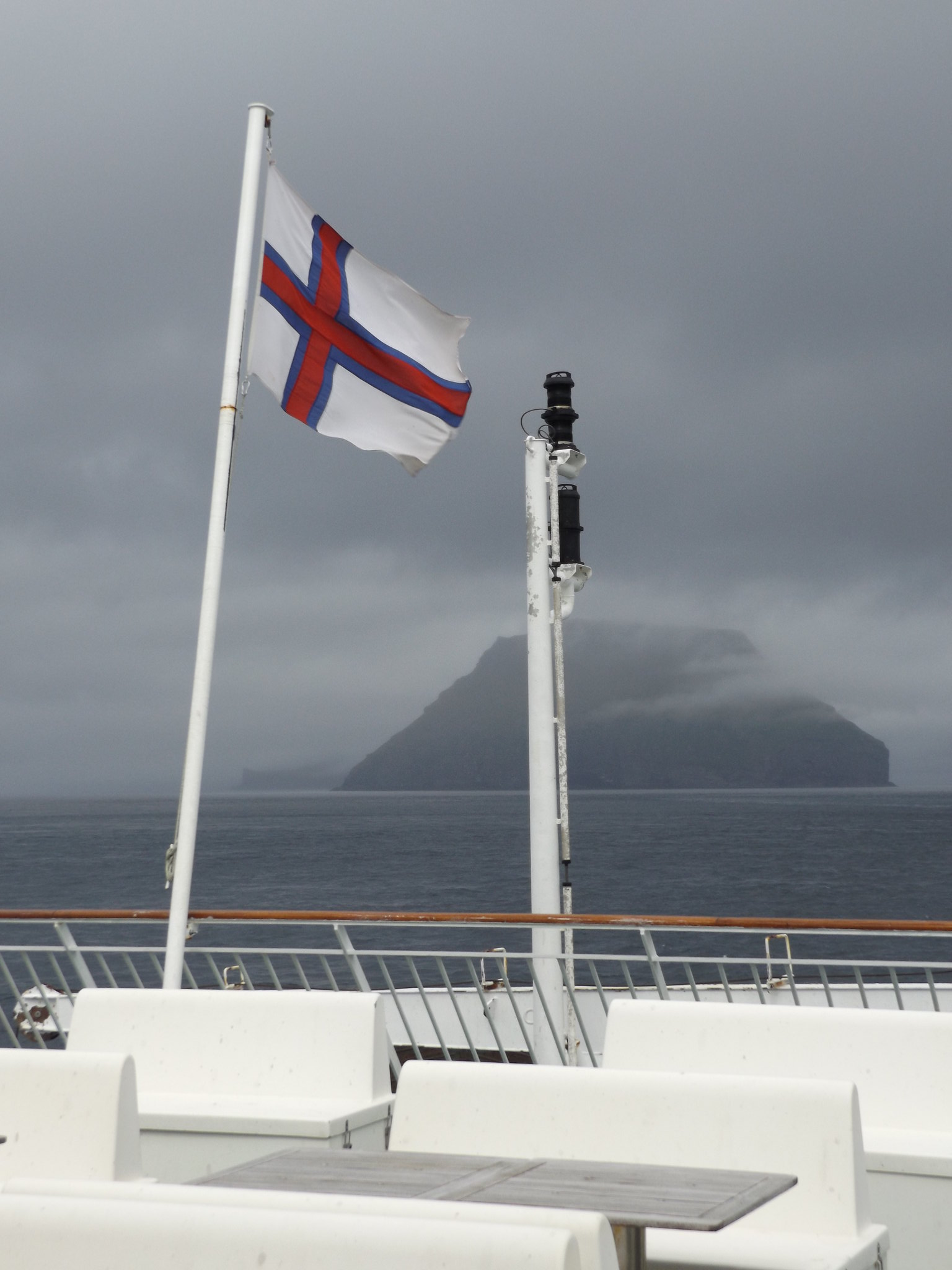
The flight departed shortly after midday. Just 75 minutes later, the plane descended through the clouds into Vágar Airport. The view from the plane window would have been spectacular on a nice day, as the descent to the runway was along a steep-sided fjord with plunging waterfalls, including the islands’ most famous and spectacular one at Gásadalur. Unfortunately, the view was obscured by low cloud and mist. Remotely situated in the North Atlantic, the Faroe Islands are often shrouded in fog and cloud, but the persistent fog of Summer 2018 was exceptional, apparently related to the weather system which was responsible for the interminable heatwave and drought which the British Isles had been experiencing since May. The plane landed ominously close to the end of the runway, just before the metal gantries supporting the end-of-runway lights which stood at the edge of Lake Sørvágsvatn. There was some time to wait until the bus, so I picked up some useful maps and booklets from the airport’s tourist information booth, before heading outside to the bus stop. Unlike the bustle of most international airports, it was almost silent apart from the occasional sound of a passing car and the piping of wading birds on the moors beyond the airport car park.
The Faroes have a good public transport system of buses and ferries. Since the opening of a road tunnel linking Vágar (the island with the airport) and the main island of Streymoy, it is an easy bus journey to the capital Tórshavn, which is the most convenient base for exploring the islands. A lot of people were waiting on the airport forecourt, and I was concerned that there would not be enough seats on the bus, but they gradually dispersed as their lifts arrived, leaving a handful of people waiting at the bus stop. However, shortly after the bus set off, a huge party of Danish scouts boarded in the village of Miðvágur, filling up all of the remaining seats.
After Miðvágur and Sandavágur, the road ascended into a mountain pass with bleaker scenery, before dropping down towards the Vágar-Streymoy tunnel. One of the surprising features of the long tunnels in the Faroe Islands is that, unlike most road tunnels in Norway, most of them are completely unlit, relying on drivers’ headlamps to guide the way. When the bus emerged from the tunnel on the Streymoy side, rugged mountains towered almost vertically above the road. Breaks in the cloud started to appear, and by the time the bus passed the port of Kollafjørður, the impressive scenery was bathed in bright sunshine. After another tunnel, the road skirted the long steep-sided fjord of Kaldbaksfjørður, eventually reaching the outskirts of Tórshavn. It was apparent that in spite of the cloud and fog, there had been a period of relatively dry weather, as the large numbers of waterfalls flanking the fjords had diminished to thin trickles dribbling down the middle of the huge ravines that had been gouged out of the rocks during periods of heavier rainfall. The waterfalls must be spectacular during the rainier autumn and winter months.
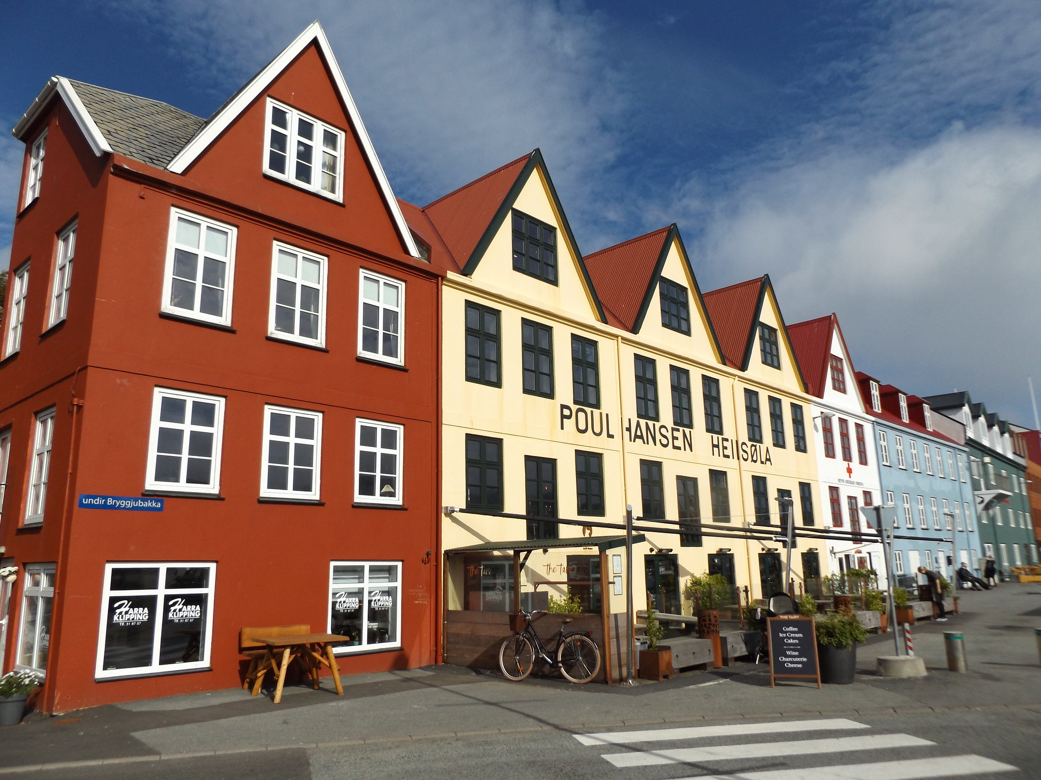
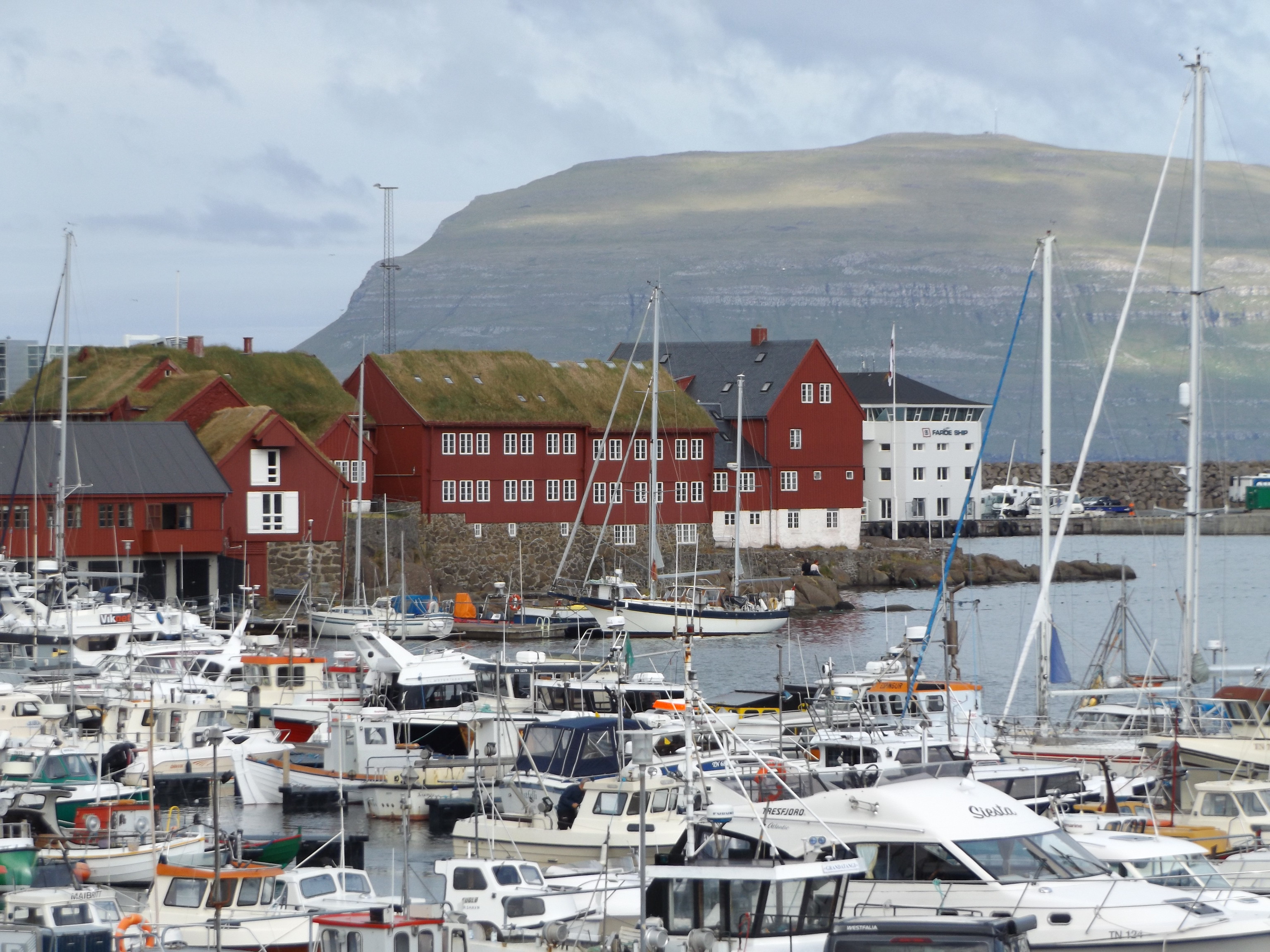
Entering Tórshavn, the bus arrived at one of the Faroe Islands’ more unusual phenomena: a set of traffic lights. It is often stated that there are only three sets of traffic lights on the islands, although I saw at least four sets in the capital alone. A few moments later, the bus arrived at its terminus in front of the ferry terminal. Dragging my luggage through the cobbled streets of the old town area on the Tinganes peninsula, I stopped for a while to take photographs by the harbour while the sun was shining, before slowly climbing the hill towards the guesthouse.
The Guesthouse Marknagil is situated high above town by the ring road, through a sprawling housing estate with streets named after other North Atlantic islands (Hetlandsvegur, Orknoyavegur etc.). It can also be reached via the city’s convenient, free bus service. Service 1 operates a rather complicated circular route around the town, passing the guesthouse twice during its circuit. Buses operate every 20 minutes on weekday daytimes, and hourly in the evenings and on Saturday daytimes (no service Saturday evenings or Sundays). The guesthouse is in a rather austere, grey concrete building which was previously student accommodation for the city’s business school. The accommodation is basic, but the staff are friendly and helpful and a hot-and-cold buffet breakfast is included in the price, which is very welcome in a country where food is so expensive. Rooms on the western side of the block have views of bleak moorland, while those on the eastern side look across Torshavn to the island of Nólsoy, although at the time of my visit the views were somewhat marred by the heaps of earth, builders’ rubble and metal barriers from the ongoing construction of the new business school nextdoor.
After dropping my luggage in my room, I set off back down into the town to buy some food. There was a small, expensive supermarket in the town’s main pedestrian shopping street, Niels Finsens gøta, where I bought some drinks and snacks. Apart from a small number of posh restaurants, choices for eating out consisted of a cluster of kebab and pizza outlets at the top of Niels Finsens gøta, near to the bus stops on Steinatún. I bought a kebab and decided to take it back to the guesthouse, as it was a chilly evening.
Day 2: Tvøroyri
After breakfast, I headed down into the town, planning to explore the town centre for a few hours in the hope that the grey, drizzly weather would improve.
Tórshavn has a strongly Scandinavian ambience, with painted wooden houses nestling down in the older part of town, reminiscent of coastal towns in Norway and Sweden. Smart, modern amenities are located around the outskirts, including an indoor shopping centre, SMS.
The oldest and most attractive neighbourhood is Tinganes, situated on a peninsula between the town’s two main harbours. The Vikings established their parliament here in 825, and it is still the seat of the Faroese government today, vying with Tynwald on the Isle of Man and Þingvellir in Iceland for the title of the oldest parliament in the world. The Løgting (Parliament) itself nowadays actually meets in the pale grey wooden building dating from 1856 on Tinghúsvegur, to the north of the Tinganes peninsula. The government occupies the prominent cluster of picturesque red-painted wooden buildings at the tip of the peninsula , including the Skansapakkhusið from 1749, which was formerly a storage warehouse and now houses the offices of the Prime Minister.
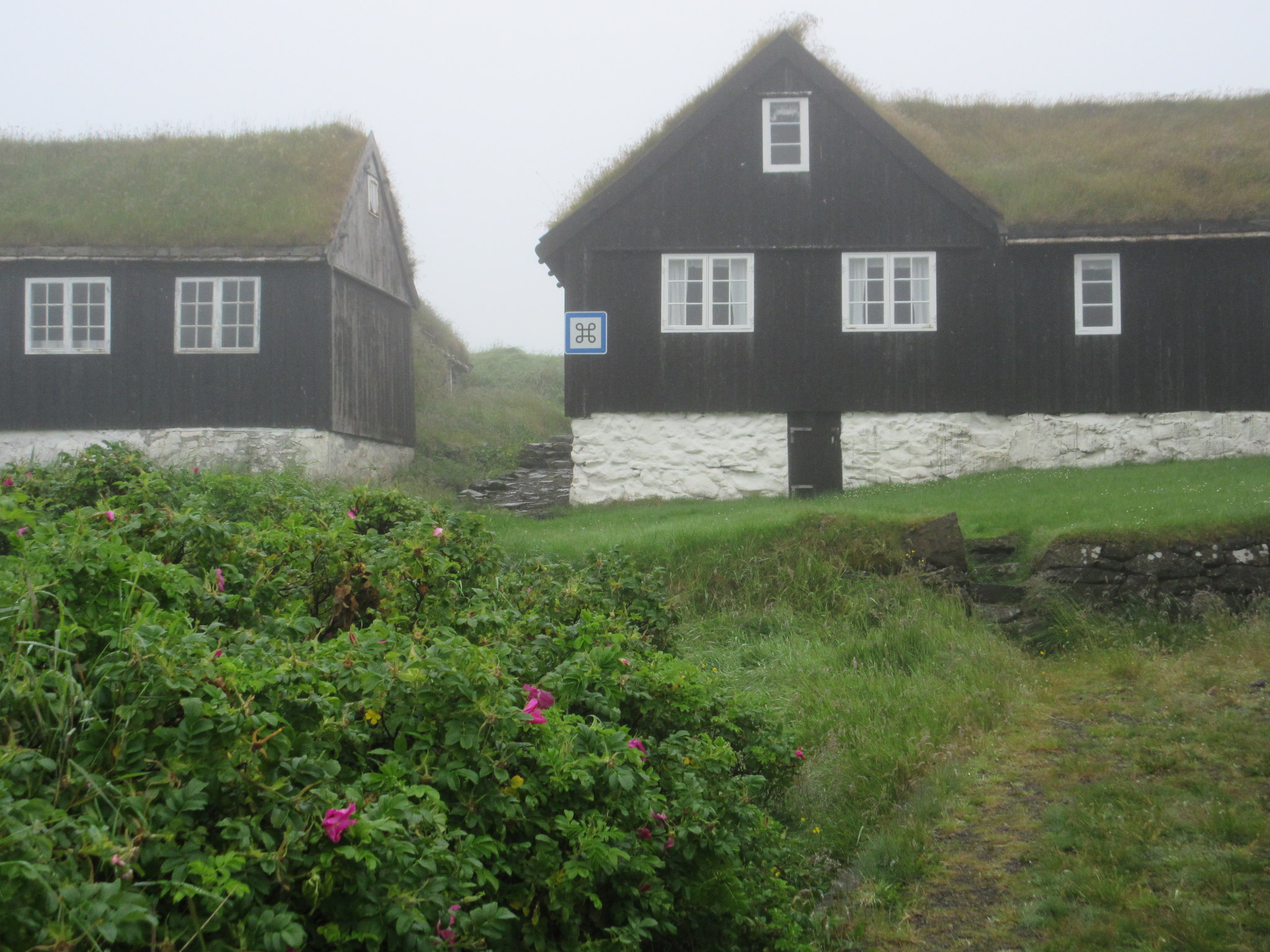
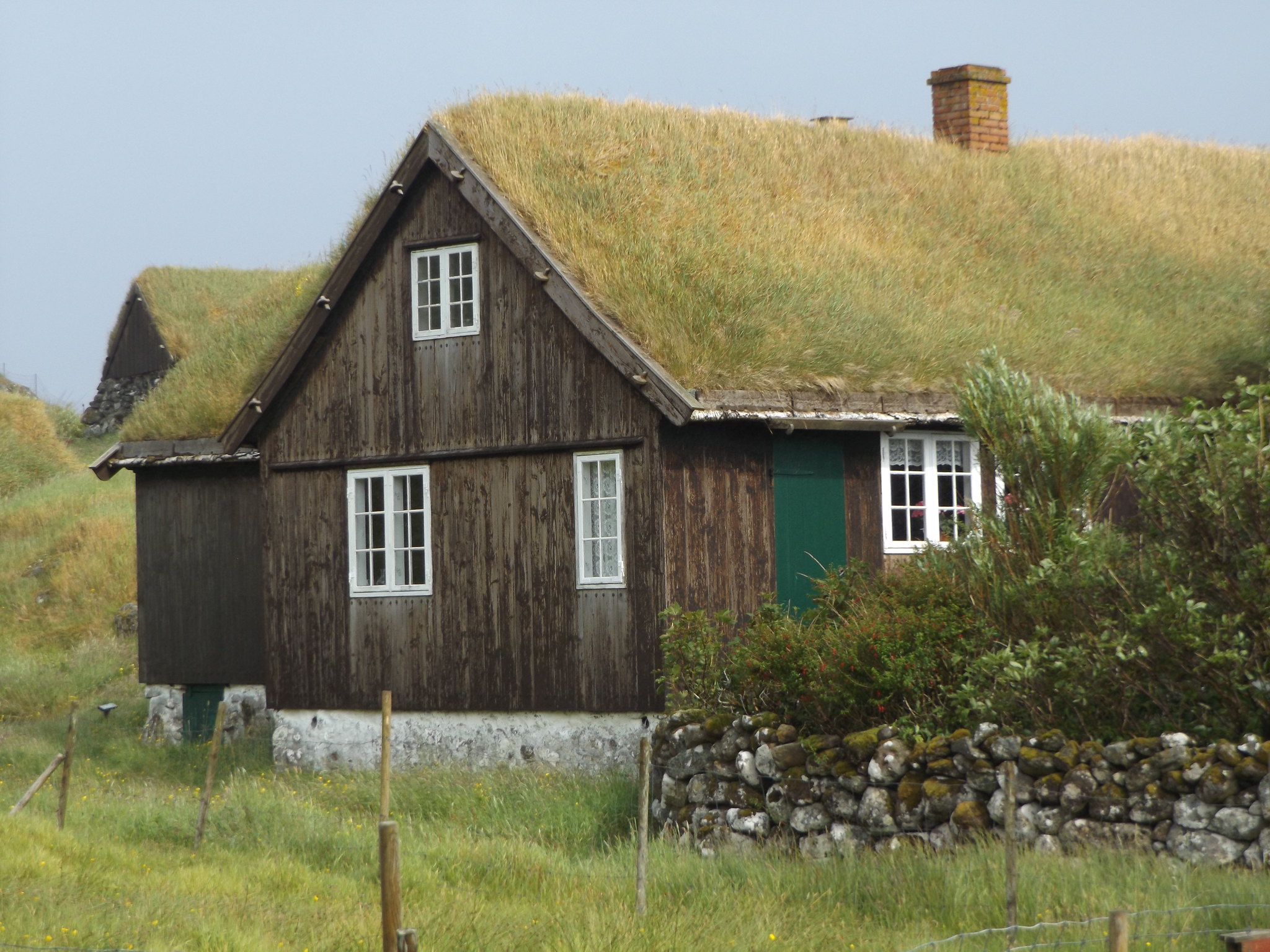
On top of the peninsula, cobbled lanes and alleys wind their way between old wooden houses, many of them grass-roofed, dating from the 16th and 17th centuries. At the northern end of Tinganes, overlooking the western harbour, stands Tórshavn Cathedral, a white-painted church with large clock faces, which was built in 1788 and remodelled in 1865. A line of brightly coloured gabled houses, nowadays housing upmarket restaurants and cafés, faces on to the western harbour, Vestara Vág, resembling a miniature version of Bergen’s Bryggen.

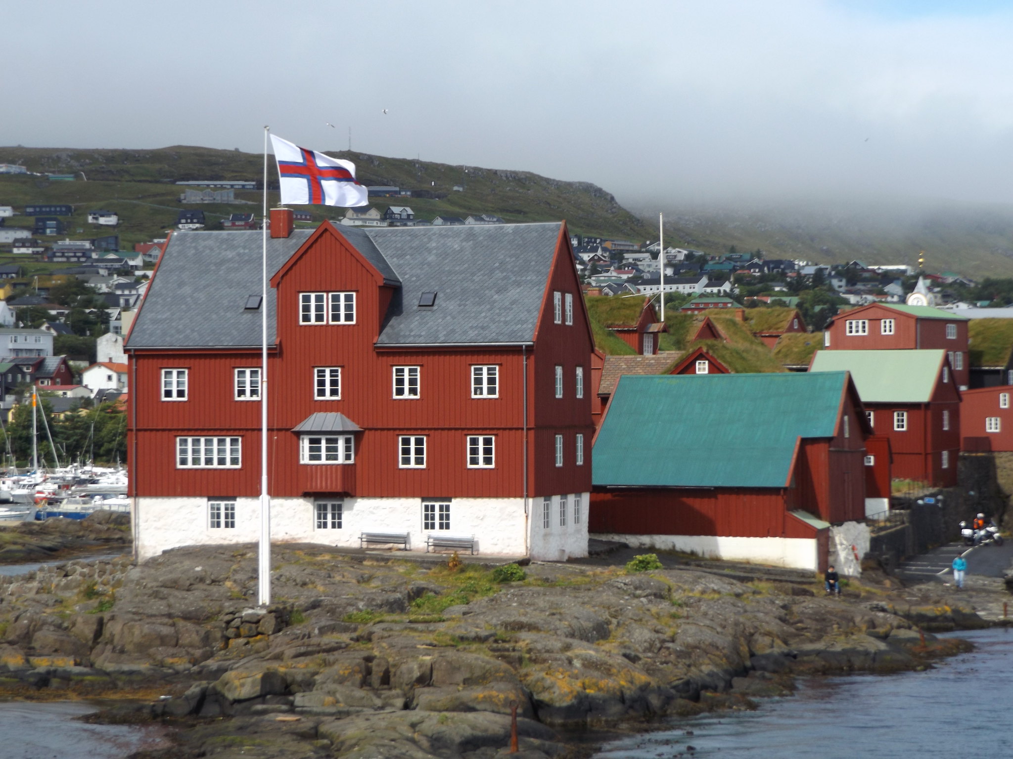
On the other side of Tinganes, beyond the eastern harbour and the ferry and bus terminals, is Skansin, a fortress built in 1580 to guard against pirate raids. It served as a military base during the British occupation of the Faroe Islands in the Second World War. Dominated by Tórshavn’s red and white lighthouse, the ramparts are lined with cannons and offer fine views across to the island of Nólsoy.

The weather showed little sign of brightening up, but I decided to proceed with plans to catch a ferry to Suðuroy in the afternoon. The Faroe Islands’ public transport authority SSL (Strandfaraskip Landsins) offers a good-value weekly pass which covers all buses and ferries (except ferries to Mykines), although the passes can only be purchased from the desk at the Tórshavn ferry terminal, which has rather erratic opening hours tying in with the major ferry departures. In order to fit in all the places I wanted to visit, I would need to spend the first three days travelling on inter-island ferries, followed by three days using the buses on the main island group, plus the return journey to the airport on the final day.
Suðuroy is the southernmost inhabited island in the Faroe Islands, separated from the other inhabited islands by quite some distance. It is about 31 miles from Tórshavn to Tvøroyri as the crow flies, although the ferry journey is nearer to 40 miles and takes over two hours. Perhaps because of its remoteness from the rest of the archipelago, Suðuroy is overlooked on most tourist itineraries, although some cruise ships call at Tvøroyri. Ferry departures to Suðuroy depart at different times each day of the week. On Fridays, the ferry departed Tórshavn at lunchtime, returning late in the evening.
After purchasing my one-week SSL pass, I climbed the stairs of the ferry terminal to board the ferry, which was already waiting at the dock. There seemed to be no ticket checks at the entrance to the ferry deck. The MS Smyril seemed absolutely gigantic for a ferry that was only going to a remote, sparsely-inhabited island two hours away, but perhaps the impression of size was misleading, set against the backdrop of small wooden buildings on the Tinganes peninsula. Nevertheless, Smyril is big enough to accommodate 975 passengers and 200 cars. Inside, it is remarkably like the Northlink ferries which run between Aberdeen and Shetland, with an almost identical restaurant area. It is the fifth Smyril (Faroese for “merlin”) to operate on the route between Tórshavn and Tvøroyri, not to be confused with Smyril Line, the long-distance operator of the much larger MV Nörrona which sails between Denmark, the Faroes and Iceland.

As the ferry sailed out of the harbour and Tórshavn began to recede into the distance, the fog became thicker and it was too windy to stand on the outside deck for long. I found a seat inside and watched the seabirds out of the window. There were only vague glimpses of the rocky coastline of Sandoy through the mist, but after about an hour and a half the dramatic outline of Lítla Dímun began to loom on the starboard side. This tiny, uninhabited island with an astonishing height of 414 metres has a distinctive profile, with sheer cliffs at the base, steep green slopes and a flat top, like a miniature table mountain protruding abruptly out of the Atlantic. As the Smyril passed close by the island, seabird activity increased dramatically, with hundreds of fulmars, puffins, guillemots and gulls skimming over the waves. As it was partially shrouded in clouds on its north side, the full profile of Lítla Dímun didn’t come into view until the ferry had passed it by and was beginning to approach the coast of Suðuroy.
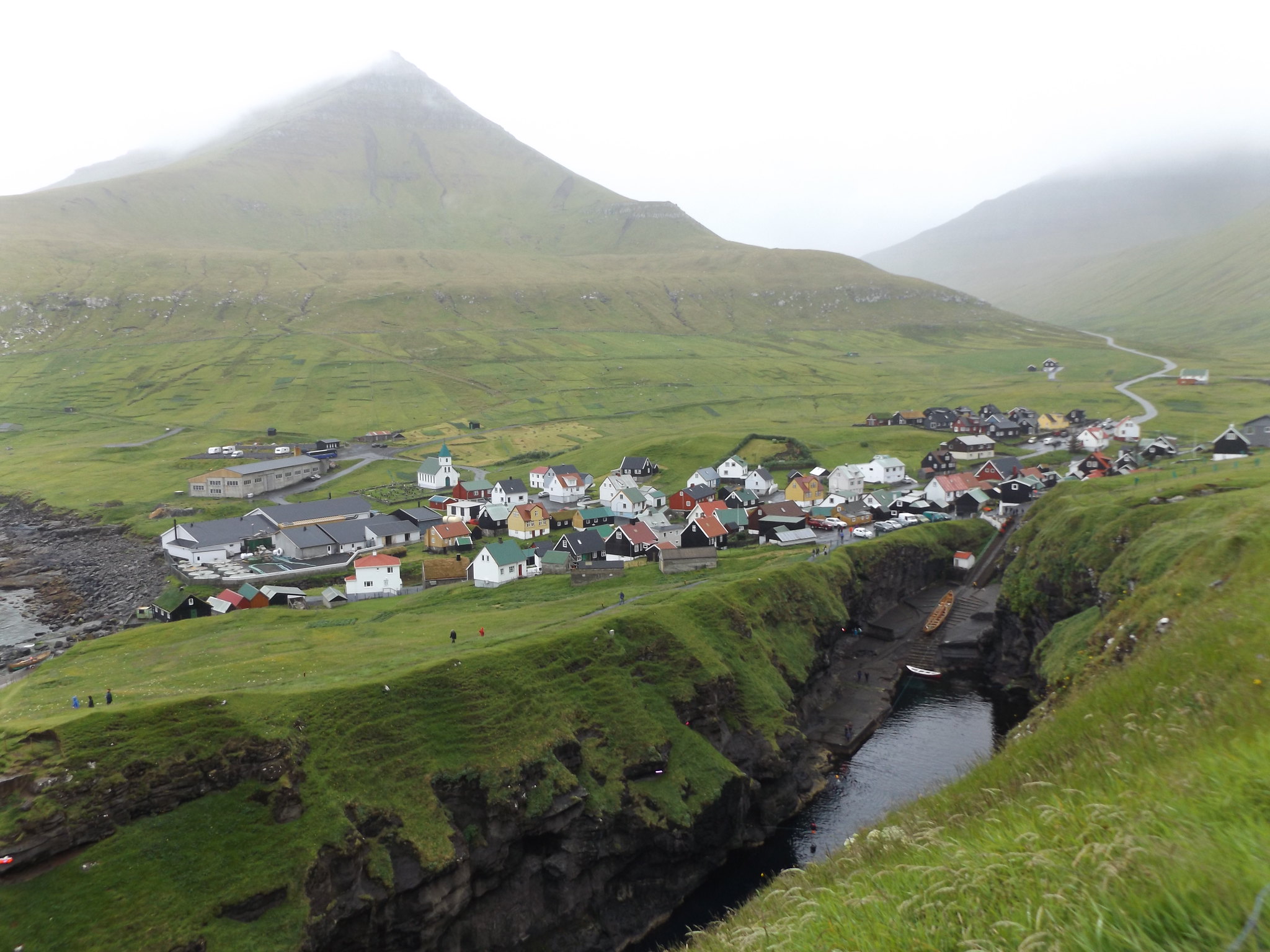
Soon after passing Lítla Dímun, the ferry turned into the fjord where Suðuroy’s main port of Tvøroyri is situated. I was surprised to discover (contrary to the impression given by most maps) that the ferry docked on the opposite side of the fjord from the town at a place called Krambatangi, necessitating a walk of over three miles around the head of the fjord to the town. There was a small bus waiting at the dock, but it didn’t seem to be heading in the direction of Tvøroyri, so I set off to walk there along the road. A short distance along the road, there was a very strange building: a huge, black-painted wooden structure with convex roof gables and a small tower at one end, which looked like a cross between an oversized village church and some sort of industrial silo. It was in fact an old salt silo, originally built in 1938 to store salt from Ibiza, which had recently been refurbished as a performing arts centre after years standing derelict.
At the head of the fjord, near the village of Trongisvágur, a boardwalk cut across marshy ground towards the road along the northern side of the fjord into Tvøroyri. While crossing the boardwalk, I heard a repeated, rasping sound coming from the vegetation, which I recognised as the call of a corncrake. It was still there when I passed by later in the evening, but despite spending some time searching, I wasn’t able to see this elusive bird.

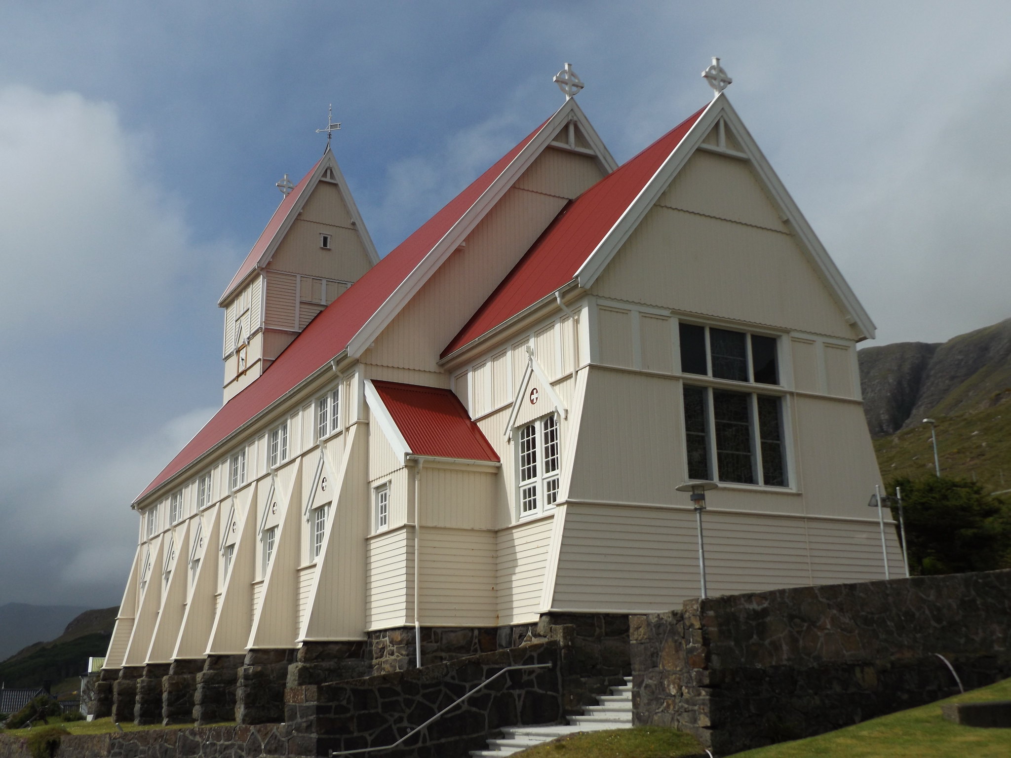
When I reached Tvøroyri, there was a brief spell of sunshine, giving the chance to admire the colourful buildings of the picturesque small fishing town and its rugged backdrop. Standing guard over the town is a large, creamy-white wooden church with steep red roofs, which has an unusual origin. It was prefabricated in Norway, before being shipped in sections to Tvøroyri, where it was erected in 1908. Its predecessor, which the town had outgrown, was dismantled and re-erected in the nearby village of Sandvík. On the hillside above the church there is a line of basalt columns, reminiscent of the ones at the Giant’s Causeway. At Froðba, a short distance to the east of Tvøroyri, there is a long stretch of road lined by similar basalt columns, which can be seen from the ferry as it enters and leaves the fjord.
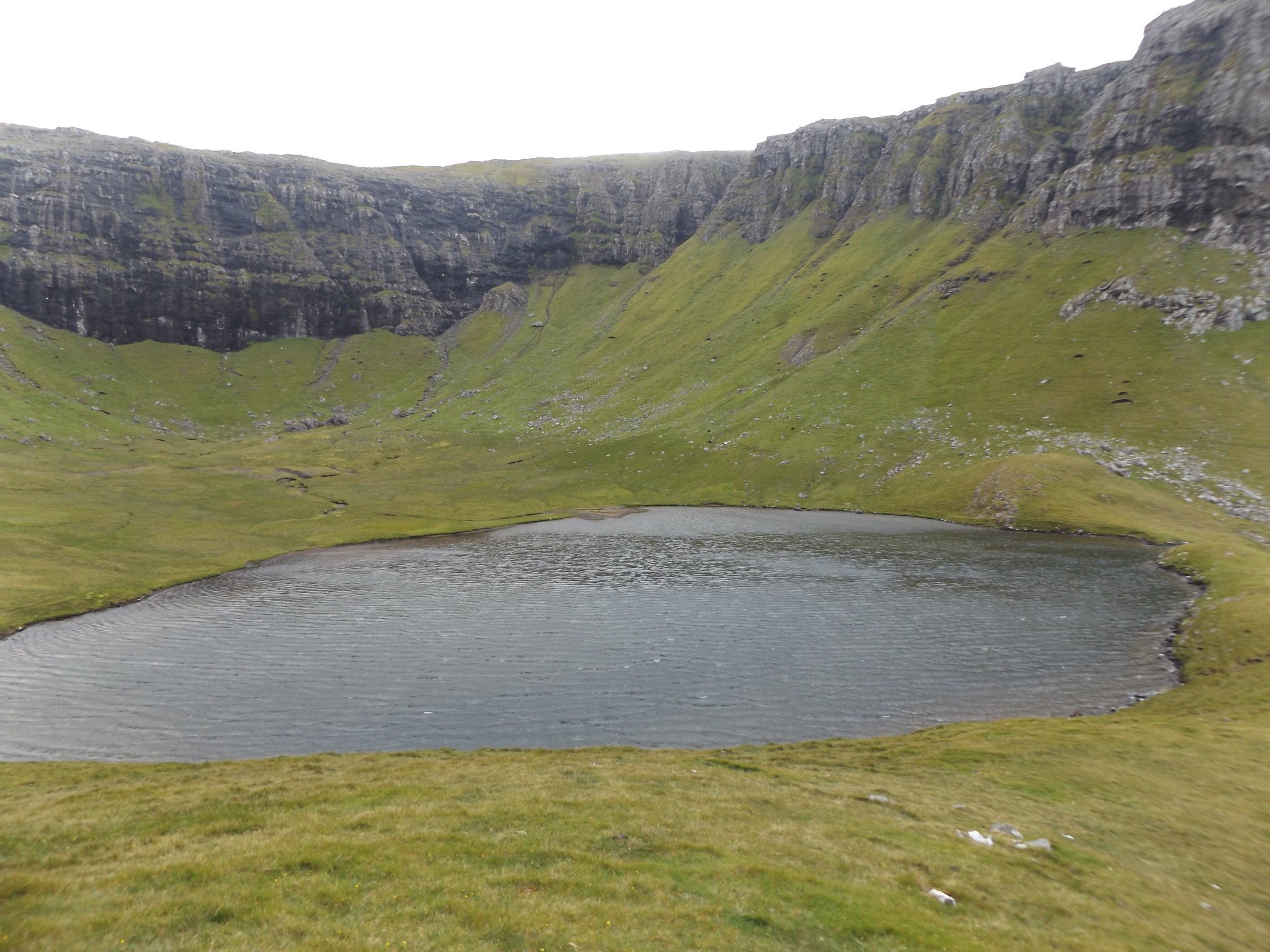
One of the most useful brochures available in tourist information centres around the islands is Hiking in the Faroe Islands (Danish version: Færøerne til fods), which describes 23 different walks across all parts of the islands, accompanied by very clear maps of the routes and photographs of the impressive landscapes to be seen on each walk. Walk 21 from Tvøroyri to Hvannhagi seemed ideal in terms of distance and stamina for my short visit to Suðuroy. It was a shame that as I set out along the road towards Hvannhagi, the sun disappeared, ominous grey clouds began to descend and it began to get windy, quite unlike the sunny photographs in the brochure. Passing through the gate at the end of the road into the “outfield” (i.e. open moorland), I climbed the steep hillside, only to discover that the path vanished into boggy ground. There were no people around and the bleak moorland was now cloaked in murky fog. I wondered whether it would be safest to turn back, but decided to persevere and eventually found my way to a gate on the other side of the moor, where there was a distinct path which descended very steeply down a ravine. At this point the fog lifted sufficiently to reveal the open sea in front of me, with the distinctive shape of Lítla Dímun straight ahead in the distance. Despite the grey, overcast weather, the dramatic scenery was worth the effort. After a short distance, the path rounded a corner to reveal the crystal-clear lake of Hvannhagi, surrounded by steep grassy slopes topped with massive crags.
The Hiking in the Faroe Islands booklet suggested that it was possible to make a loop by returning from Hvannhagi via a different route, but it wasn’t at all clear where the path up the cliffs was, and it was apparent that specialist climbing skills would be needed, so there was no option but to return the same way I had come. On the way up the steep path to the top of the ravine, I bumped into a young British couple who were on holiday in the Faroes for two weeks, the only people I saw during the walk.
Crossing the moorland was easier on the way back, as the fog had cleared although it remained overcast. Although I was quite close to Trongisvágur at the head of the fjord, from where it was only a short distance back to the ferry port, there was no path down to Trongisvágur, so I had to walk all the way to Tvøroyri, before turning back along the almost parallel road lower down the hillside. I still had several hours until the ferry departure. On the way back to Tvøroyri, I passed through a community woodland which offered a pleasant respite from the otherwise treeless landscape.
By the time the ferry set out at 9 pm, it had turned very gloomy and soon started to get dark. I bought a meal from the restaurant and stayed inside for the whole journey. Arriving back in Tórshavn, I walked up the hill to the guesthouse, arriving back at my room just before midnight.
Day 3: Sandoy and Kirkjubøur
I had a fairly early start the following morning, as I was planning to go to the island of Sandoy and needed to be at the bus stop by 9.20. Unfortunately, it was another cold, drizzly and misty morning. The ferry to Sandoy doesn’t leave from Tórshavn; instead, you have to catch a bus to Gamlarætt, a few miles away on the opposite side of the peninsula on which Tórshavn sits at the southern end of Streymoy.
I was the only passenger on Bus 101 as it set off from Torshavn’s bus terminal, although a few other passengers boarded on the way out of town. It was bleak and rainy as the bus ascended on to the moors. Arriving at the ferry terminal in Gamlarætt, the bus waited for the ferry to arrive, enabling passengers to shelter from the rain. It was a small roll on-roll off ferry, which foot passengers boarded through the main car ramp. The crossing took half an hour and gave good views of seabirds skimming across the water, but there was little to see in the way of landscape because of the persistent mist. Arriving at Skopun, I boarded a 601 bus to Sandoy’s main village of Sandur. I was hoping to do another of the walks in Hiking in the Faroe Islands, but when the bus arrived in Sandur, the village was cloaked dense fog.
After having a look at Sandur’s harbour, church and shop, I couldn’t see much else to do in the village in such bleak weather, so I decided that I might as well set out on the walk, hoping that the fog might eventually clear. Soon after leaving the village, I was approached by a large, scraggy dog with ice-blue eyes, which started to follow me. There seemed to be no other people around, so perhaps the dog belonged to one of the houses on the way out of the village. After a while, the dog ran off towards a headland above the cliffs where some sheep were grazing. However, he soon came back, and started to follow me along the road again, waiting patiently for me when I dropped back hoping to shake him off. In the end, he must have followed me for over two miles out of the village, until I decided to turn back. There was no prospect of the fog dispersing and nothing to see, apart from the occasional inquisitive seabird swooping down out of the mist.

Realising that I had turned back, the dog soon rejoined me, trotting along the road back towards the village. Terrifyingly, at a point where the road ran along a ledge above sheer cliffs, he suddenly jumped on to the wall by the road, stared straight down the steep cliffs towards the frothing waves below, and then jumped off the other side of the wall, disappearing from view. After a moment, he reappeared, running along the exposed clifftops. On the approach to the village, I saw a group of people camping in a field by the road. The dog went off to investigate them, and didn’t follow me for the rest of the way back into the village.
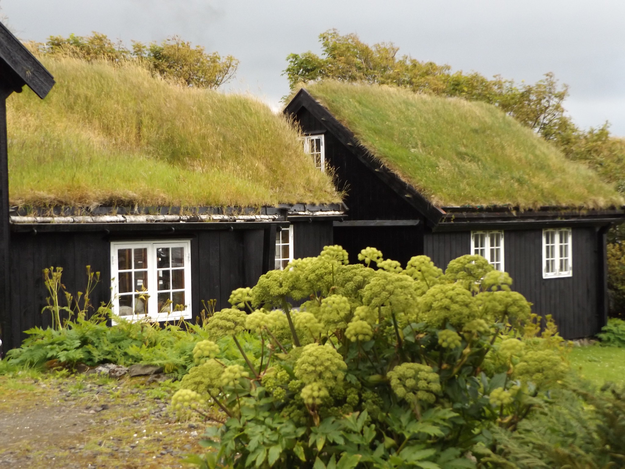
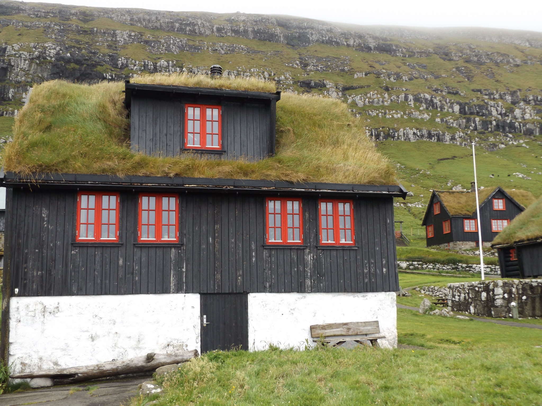
Spotting the bus approaching along the main street, I hailed it, thinking that I might as well go back to Skopun as the fog wasn’t clearing. The driver explained that he would be returning to Skopun in about half an hour. While waiting for the bus, I decided to have a look inside the Sandur village museum (Sands Bygdasavn), which was part of a cluster of old-looking, grass-roofed wooden buildings, behind a rain-soaked garden full of pink dog roses. The museum itself was rather thin on exhibits, but the old wooden house with its log fire was atmospheric and cosy on this cold, gloomy day. The museum was staffed by an elderly Faroese man, who had once been a fisherman ranging as far away as Greenland and UK waters. He was keen to show me photographs of the family who had lived in the house, as well as all of their relatives.
When I arrived back in Skopun, the weather seemed to be brightening up a bit, but a ferry was approaching from Gamlarætt and I decided to head back to Streymoy, which would enable me to spend the rest of the afternoon exploring Kirkjubøur.
Cutting across the steep grassy slopes rather than walking along the switchback road up from the harbour at Gamlarætt, I set off along the road towards Kirkjubøur, about a mile to the east. Kirkjubøur is one of the most important historic sites in the Faroe Islands. Its Gothic cathedral of St Magnus was the religious and cultural centre of the islands in the Medieval period.

On the way into the village, I saw an elderly man standing at a bus stop, which was strange, as I knew that the bus service to the village didn’t operate on Saturdays. The man attempted to speak to me in Faroese and Danish. When he realised I was English, he asked me whether I had been stationed in the Faroe Islands during the Second World War! He explained that he lived in one of the more modern-looking of a cluster of houses to the west of the village (his son lived in one of the older, grass-roofed houses). Pointing across to the distant village of Skopun which was now lit up by a pool of hazy sunshine, he said that he had been born there and had swum across the treacherous straits to Kirkjubøur, where he had met a beautiful girl on the shore and married her.
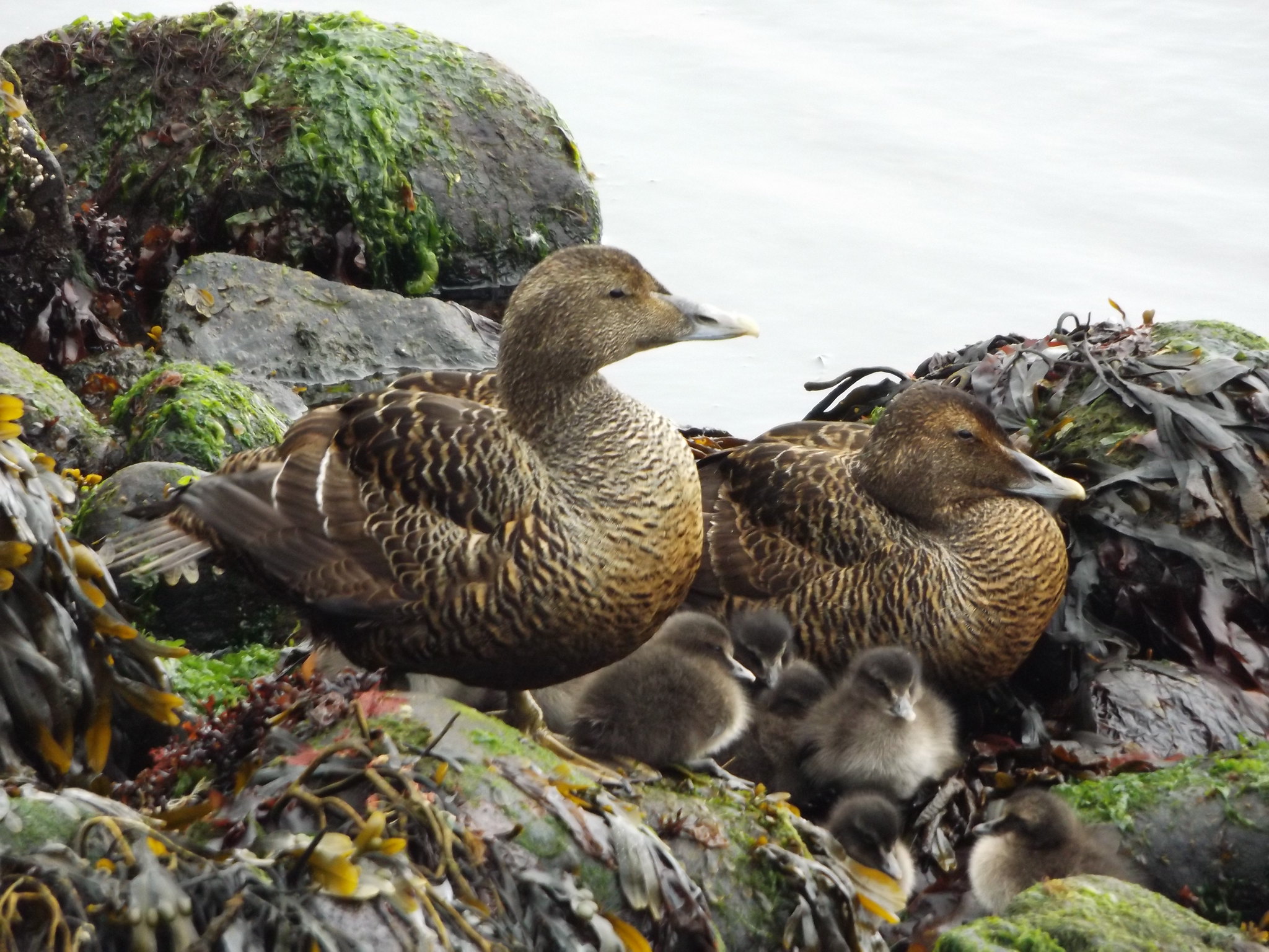
At the centre of the village, little more than a rectangle of thick, crumbling walls with arched windows survives of St Magnus’s Cathedral, and the building was covered in scaffolding for ongoing conservation work when I visited. More picturesque was the adjacent parish church of St Olav, the oldest church still in use in the Faroe Islands, dating from 1111. On the beach behind the church, female eider ducks sat protecting their young ducklings at the water’s edge.
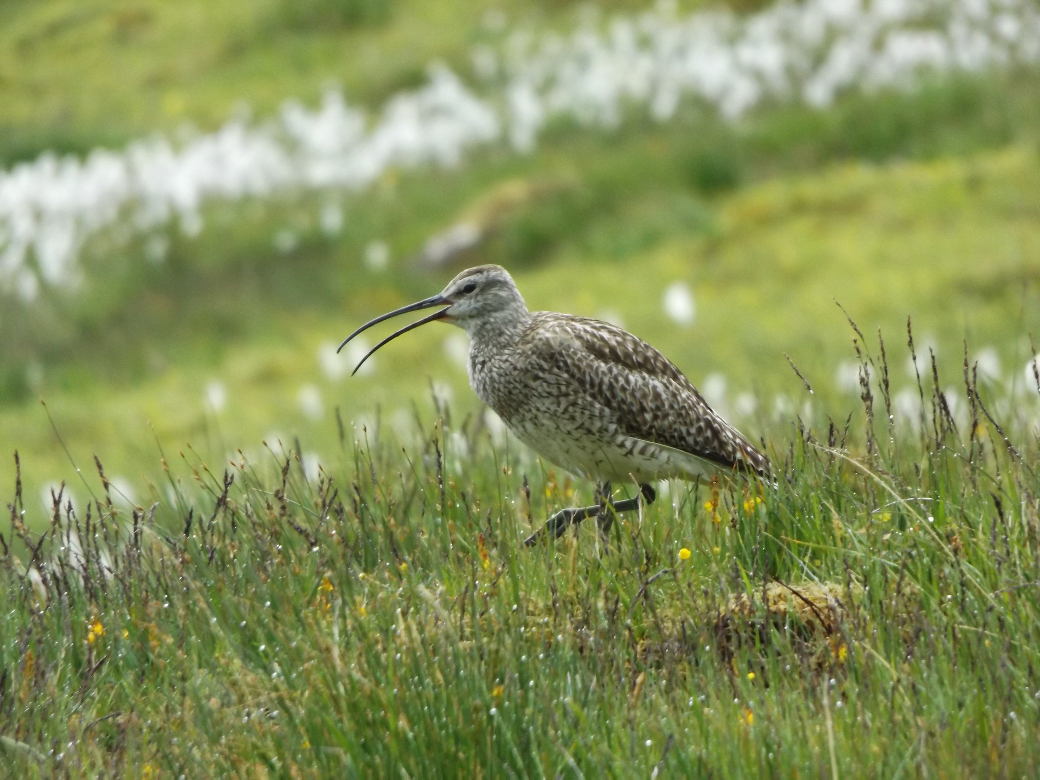
It was a four mile walk over the moors back to Torshavn, accompanied by the alarm calls of whimbrels. Arriving on the outskirts of the town, I bought some food from a small supermarket near the guesthouse, before returning to the warmth of my room.
Day 4: Hoyvík and Nólsoy
As it was Sunday and few buses were running, I decided to spend the morning visiting the Faroe Islands’ National Museum, and the afternoon taking a ferry to the nearby island of Nólsoy.
It was showing signs of being a brighter day as I set off on foot along the ring road towards Hoyvík, where the National Museum is located. The museum (Tjóðsavnið) is rather oddly situated in a utilitarian, nondescript building in a business park on a high bluff outside Tórshavn.
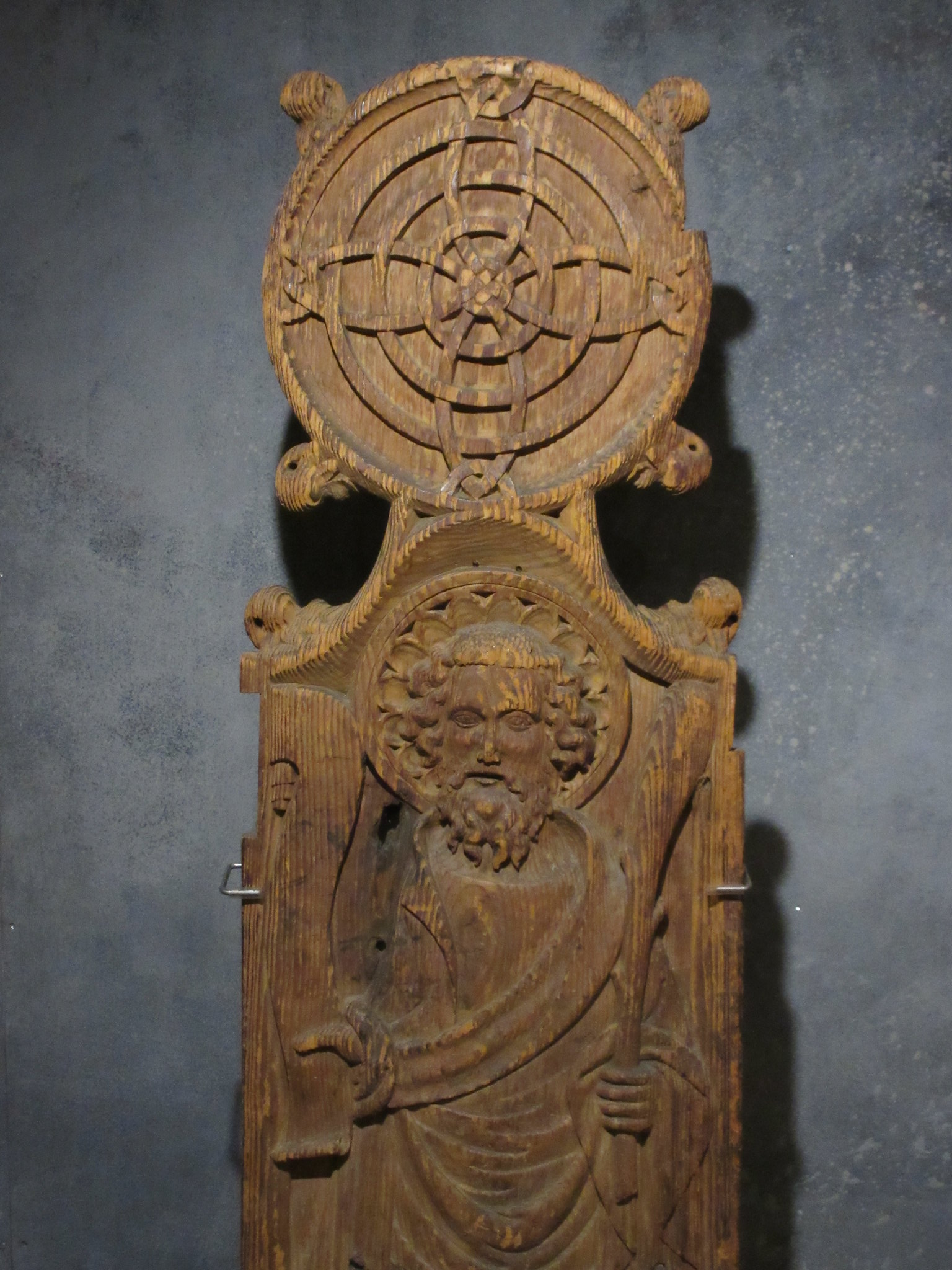
The museum is well presented, with displays on the geology, natural history, archaeology, religious and maritime traditions of the islands. Perhaps the most memorable exhibit is the set of ornately carved wooden pew ends from St Olav’s Church in Kirkjubøur, which are displayed in a small room in the middle of the lower floor.
The entry ticket includes admission to a small open air museum at Hoyvíksgarður, down by the coast a short distance from the main museum. You can explore the fully-furnished interior of the main farmhouse with its characteristic grass roof, as well as various outbuildings.
As I set off back towards Tórshavn, I got drenched in a sudden rain shower. Looking for shelter from the rain and lashing wind, I headed into Viðarlundin, Tórshavn’s main park and one of the largest areas of woodland in the Faroe Islands. Fortunately, when I reached the town centre, the weather had begun to brighten up and I soon dried off.
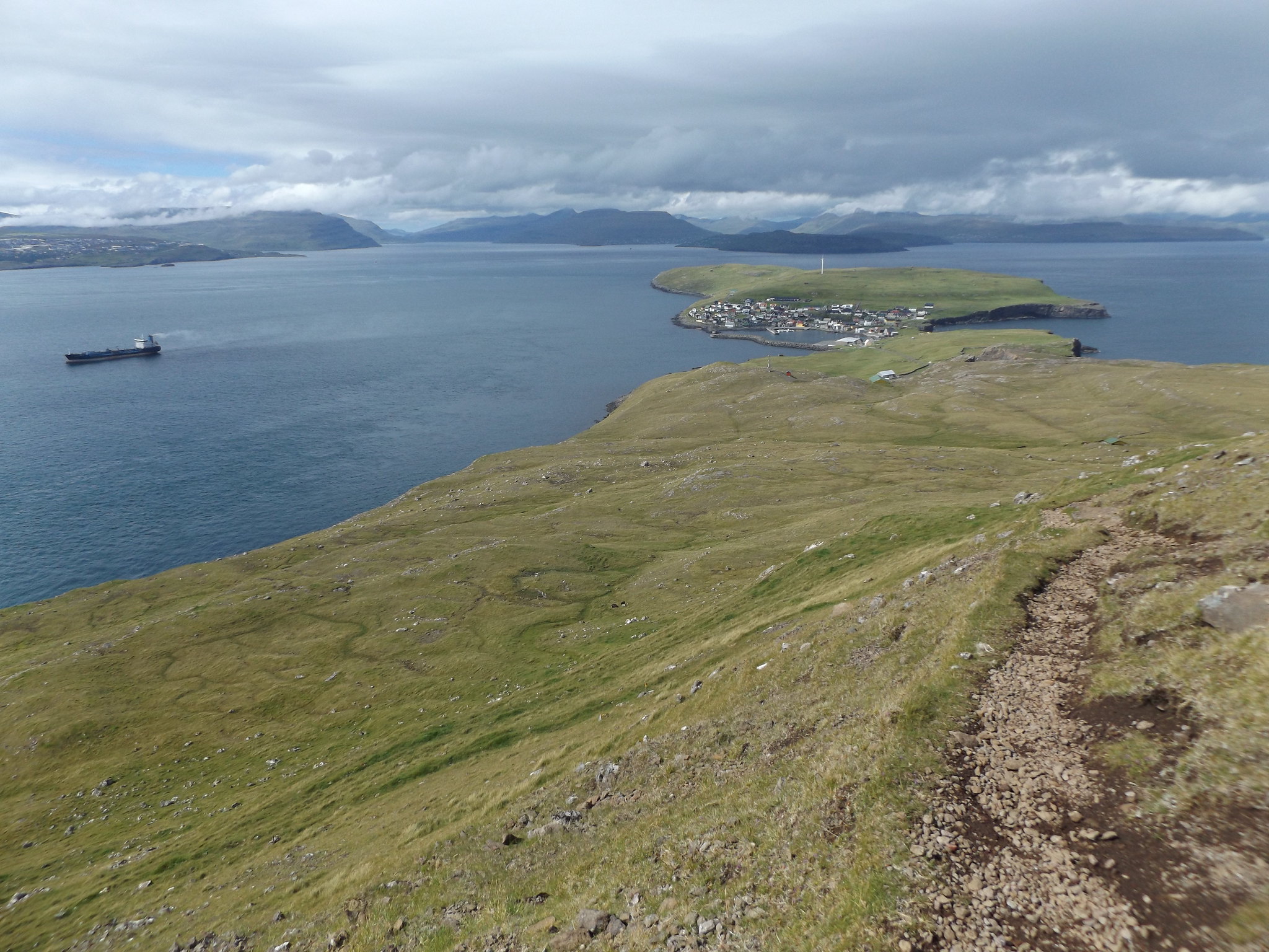
In the afternoon, I took the short ferry journey on the MF Ternan to Nólsoy. As well as taking daytrippers from Tórshavn to the island, the ferry serves commuters from the island’s only village, who work in the capital but choose to live on Nólsoy where house prices are cheaper.

The village is one of the Faroe Islands’ most evocative, with brightly coloured houses situated on a low isthmus between higher ground to the north and south. It has a population of just over 200 people. There are hardly any cars on the island and no roads beyond the village.
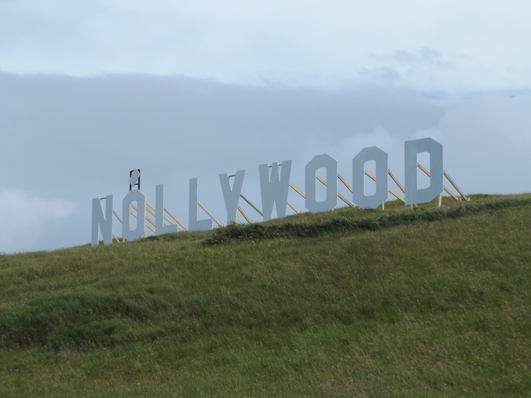
After exploring the village, with its “NÓLLYWOOD” sign over the harbour, whalebone arch and wooden church, I headed south along the narrow road past the harbour towards the steep hill of Høgoyggj. A path leading to the southern end of the island skirts along the western flank of the hill, climbing steeply to a viewpoint at Hvíliplássið (“Resting Place”). The summit of the hill was still shrouded in low cloud when I set off, but the sky gradually brightened as I climbed higher and eventually the cloud broke to reveal a fantastic view down to the village and the northern end of the island, with a backdrop of the rugged mountain chains of Eysturoy and Streymoy.
On the way down, I felt a sudden whoosh of air as an arctic skua swooped aggressively over my head. This behaviour is more commonly associated with great skuas (bonxies). Incidentally, the word “skua” is the only one in the English language borrowed from the Faroese language: “skúgvur” is the Faroese for “great skua”.
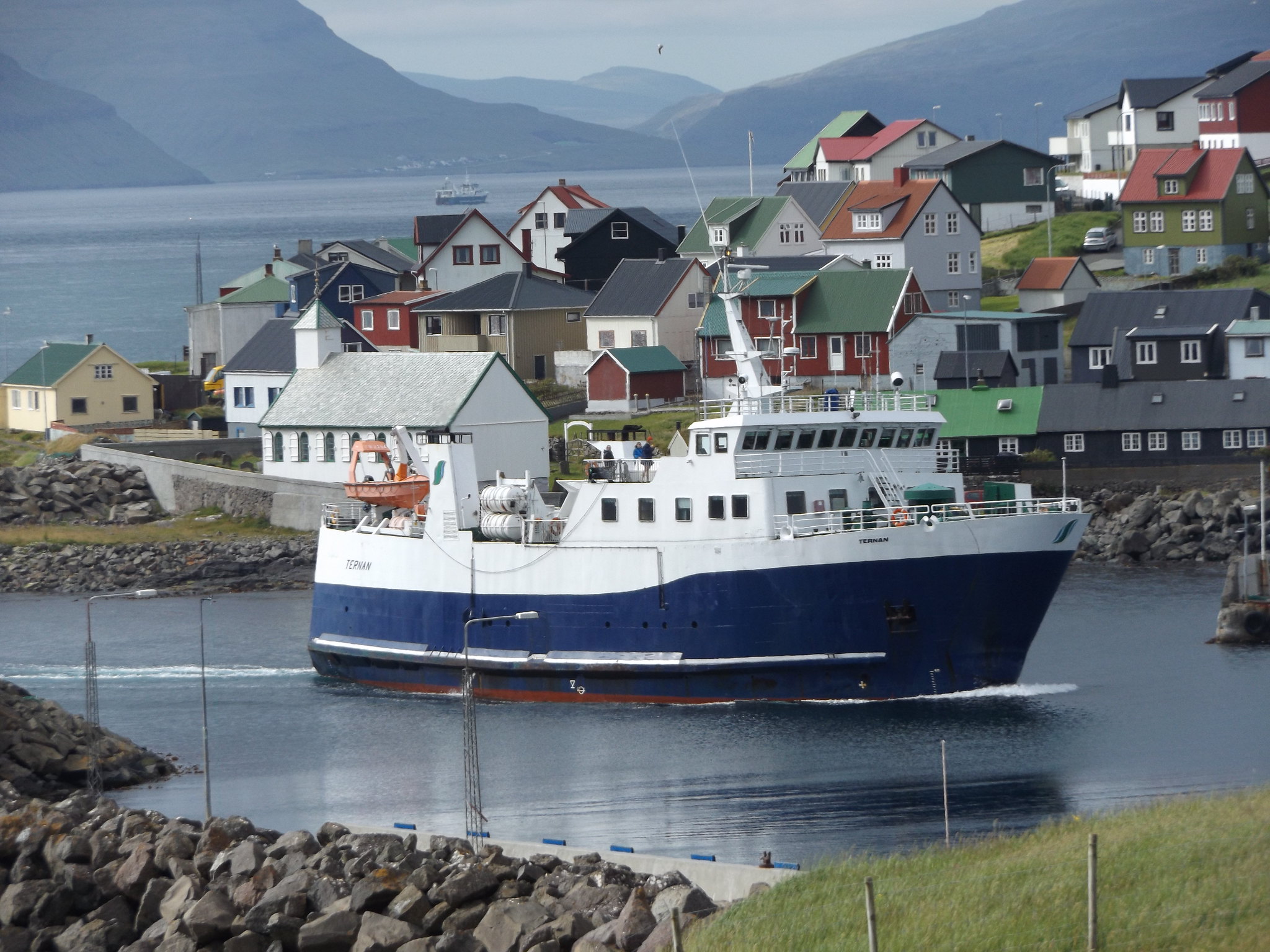
I arrived back in the village just as the MF Ternan was approaching. Docking in the small harbour, the ferry soon set off for the short journey back to Tórshavn, with kittiwakes gliding in its wake.
When I got off the ferry in Tórshavn, the town centre was crowded. A large screen had been set up facing the steps in front of the cathedral, and hundreds of people had gathered on the steps to watch the World Cup Final. As soon as the match had finished, the screen and loudspeakers were rapidly swept away, the people dispersed, and the town went quiet, although the sun continued to shine for a few hours.
Day 5: Klaksvík and Viðareiði
Having visited three islands by ferry, I wanted to spend the next few days exploring the main cluster of islands in the north of the archipelago. Seven inhabited islands are crammed close together, separated only by narrow straits, connected to each other by bridges or tunnels. Most of the mountain chains, straits and fjords are aligned on a northwest-southeast axis. The mountains are not especially high (the highest, Slættaratindur is only 880 metres), but they rise abruptly and dramatically from the ocean. The islands were formed by a series of volcanic eruptions 54-58 million years ago, producing layers of basalt interspersed with sedimentary rocks. Over the last few million years, successive ice ages have sculpted the landscape to give the islands their current appearance. In many places, steep, green mountains emerge straight from the water, ribbed with horizontal strands of exposed rock. Elsewhere, gigantic cliffs tower over the sea; the most impressive of these, at Enniberg on Viðoy, are over 700 metres high.
I planned to spend Monday on the northernmost island of Viðoy, which involved a lengthy bus journey to the islands’ second largest town, Klaksvík, followed by a shorter journey on a local bus. Klaksvík is just 16 miles (26 km) from Torshavn as the crow flies, but the complex topography of the islands means that the journey by road is 47 miles (75 km), taking about an hour and a half by bus.

When the bus arrived in Klaksvík, it seemed a surprisingly large and important place, with a large, busy supermarket, houses stacked along both sides of a steep fjord and a large construction project near the centre. One of the surprising things about the Faroe Islands is how busy and populous they seem compared to the Shetland Islands. There always seems to be a steady stream of traffic on even the remotest roads. The Faroes actually have a very similar land area to Shetland (1,399 km² or 540 square miles, compared to 1,466 km² or 566 square miles), but they have twice the population, and it is perhaps more concentrated into particular areas and corridors because of the mountainous topography. Nevertheless, when I got off the bus, it became apparent that there wasn’t really a town centre, just a smattering of shops along a single street on the eastern side of the fjord. The bus station was in a run-down area near the head of the fjord, with a dilapidated waiting room and revolting public conveniences. A large new housing and retail complex was being built nearby, which will hopefully give the town a greater focus.
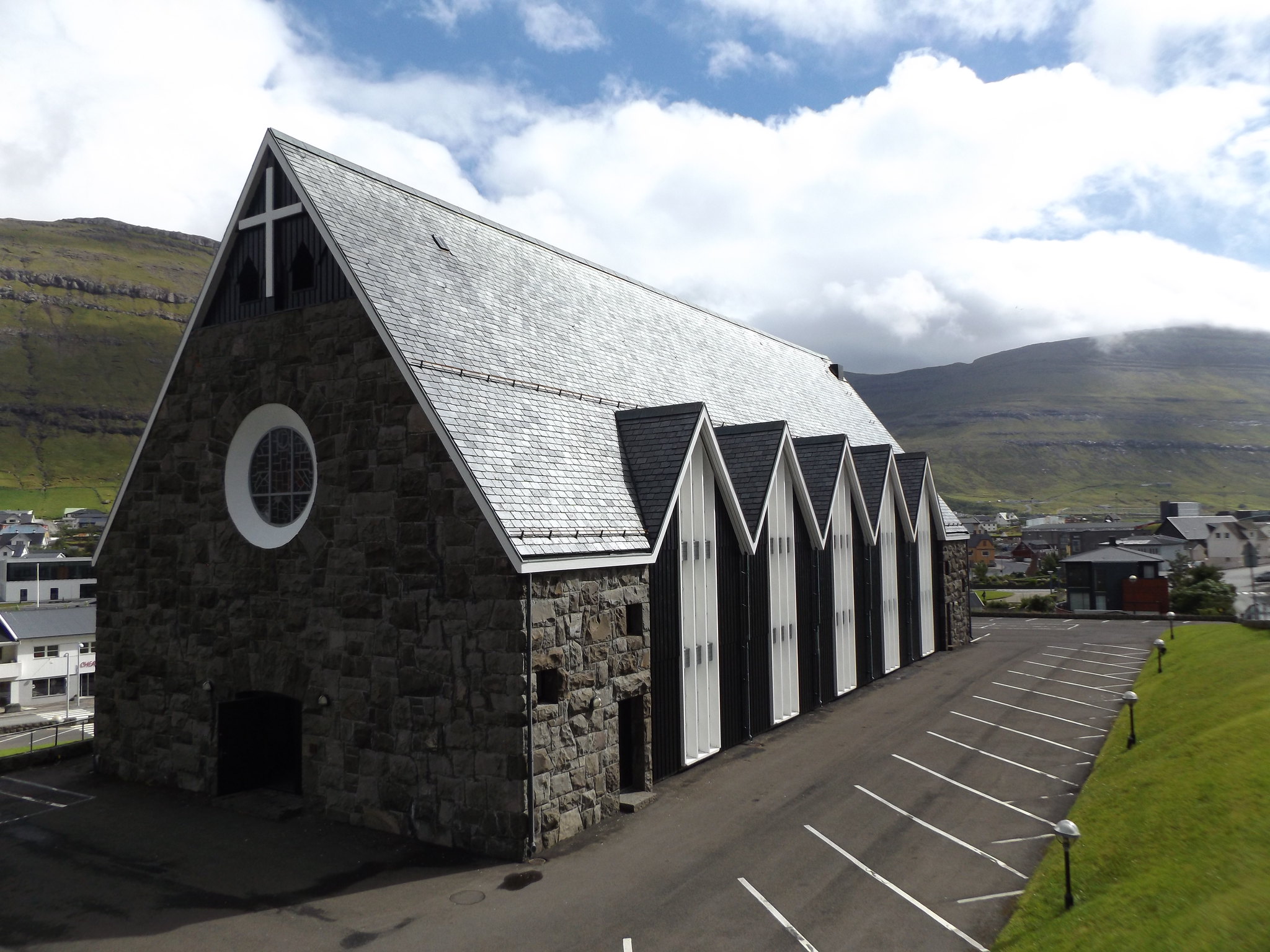
Klaksvík’s most interesting sight, Christianskirkjan, stands on a hillside on the western side of town. Consecrated in 1963, the church was designed by the Danish architect Peter Koch in “Old Norse” style, inspired by Viking construction techniques as well as the design of traditional Faroese wooden churches. A man who saw me taking photographs of the church encouraged me to go downstairs to the basement, where there was an unusual work of art consisting of eleven circular reliefs depicting biblical scenes made by the local artist Edward Fuglø.

After a quick visit to Klaksvík’s tourist information centre, I caught the 500 bus to Viðareiði on the island of Viðoy. The narrow strait separating the islands of Borðoy and Viðoy is crossed by a bridge, after which the road enters a 1,939m-long tunnel through the steep ridge of mountains which forms the backbone of Viðoy. As the tunnel is only the width of a single vehicle, with only a few passing places, the bus had to wait some time for oncoming vehicles before entering it. It is actually possible to reach Viðareiði without going through the tunnel, as there is a road along the western shore of the island, but it is prone to closure because of landslides and avalanches, hence the construction of the new tunnel in 2016.

The Faroe Islands’ northernmost village, Viðareiði, is beautifully situated in a valley between Malinsfjall and the northernmost fell, Villingardalsfjall. I was looking forward to completing walk 1 in the Hiking in the Faroe Islands booklet, which featured a photograph from the top of Villingardalsfjall over the distant houses of the scattered village to the steep cone of Malinsfjall bathed in sunshine on the other side of the valley. I only had about four hours to spare before the return bus to Klaksvík, and the booklet suggested that the climb would take three to four hours (return), so I was not sure whether I would make it to the top.
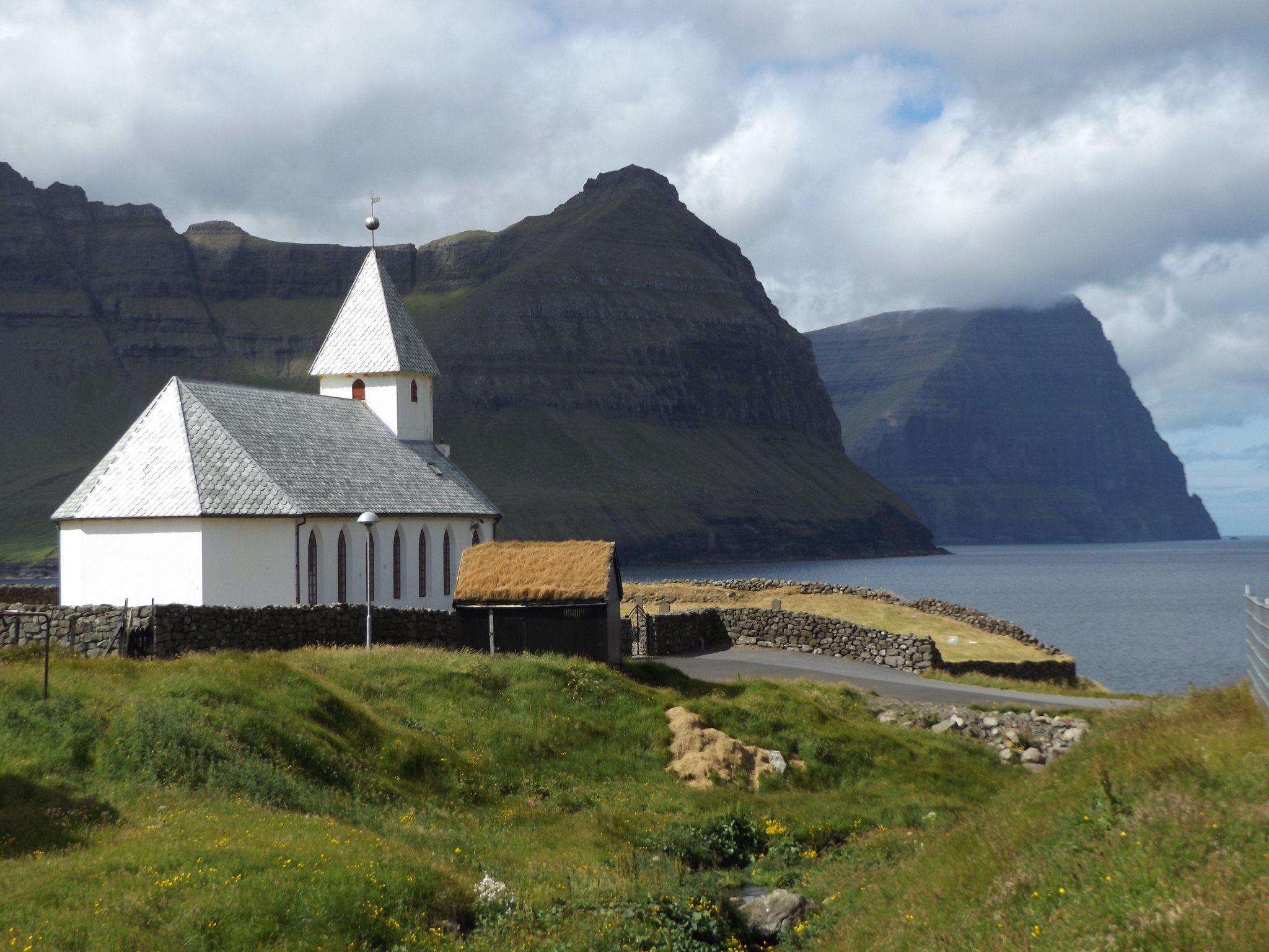
Before starting the climb, I wanted to explore the village, which was enjoying a rare spell of bright sunshine when I arrived. The scattered houses stretched right along the valley from coast to coast, arranged into two main clusters on either side of the valley at the foot of the two mountains. There was a separate cluster of older buildings around the church at the western end of the village, overlooking a small rocky beach. The little white church with its pyramid-shaped spire was one of the most evocative sights in the Faroe Islands, with its backdrop of dramatic headlands on the islands of Borðoy and Kunoy.

From the churchyard, I headed up a track through farmland to the start of the path up to Villingardalsfjall. Ahead loomed a curved mountain ridge, glowing almost yellow in the sunshine. The trail, marked with small blue plastic tubes, led the way up the main bulk of the mountain at the western end of the ridge. As the gentle grassy path turned abruptly to climb the steep mountain side, there were spectacular views over the rocky headlands of the neighbouring islands of Borðoy and Kunoy. Two younger, fitter men overtook me, as the strenuous climb demanded frequent rest breaks to stop and admire the fantastic view down towards Viðareiði. The gritty path was slippery and at several points it was necessary to scramble over boulders and loose rocks. The two younger men decided not to proceed any further and set off back down the mountain. Having negotiated a particularly difficult stretch of rocks, I decided to go a little higher, although I was becoming very jittery and didn’t expect to go all the way to the top. It soon became clear that I was already very near the top of the steepest section, so I decided to persevere to the summit, the third highest in the Faroes at 841 metres.

At the summit, there was an abrupt drop to the Atlantic Ocean below, partially obscured by low cloud and sea mist. Somewhere in the mist at the end of the promontory were the Enniberg cliffs, Europe’s highest sea cliffs at 754 metres. There was a clearer view to the southeast, along the knife-sharp mountain ridge towards the distant island of Fugloy.

It was cold and windy at the summit, and an ominous-looking thick band of cloud was approaching from the south. Descending the mountain over the loose stones and sharp boulders was challenging, and I was relieved when the path eventually reached level ground. I had about half an hour to wait for the bus back to Klaksvík.
Back in Klaksvík, the weather had turned cloudy and chilly, and I was very glad when the warm bus arrived for the long journey back to Tórshavn.
Day 6: Vestmanna
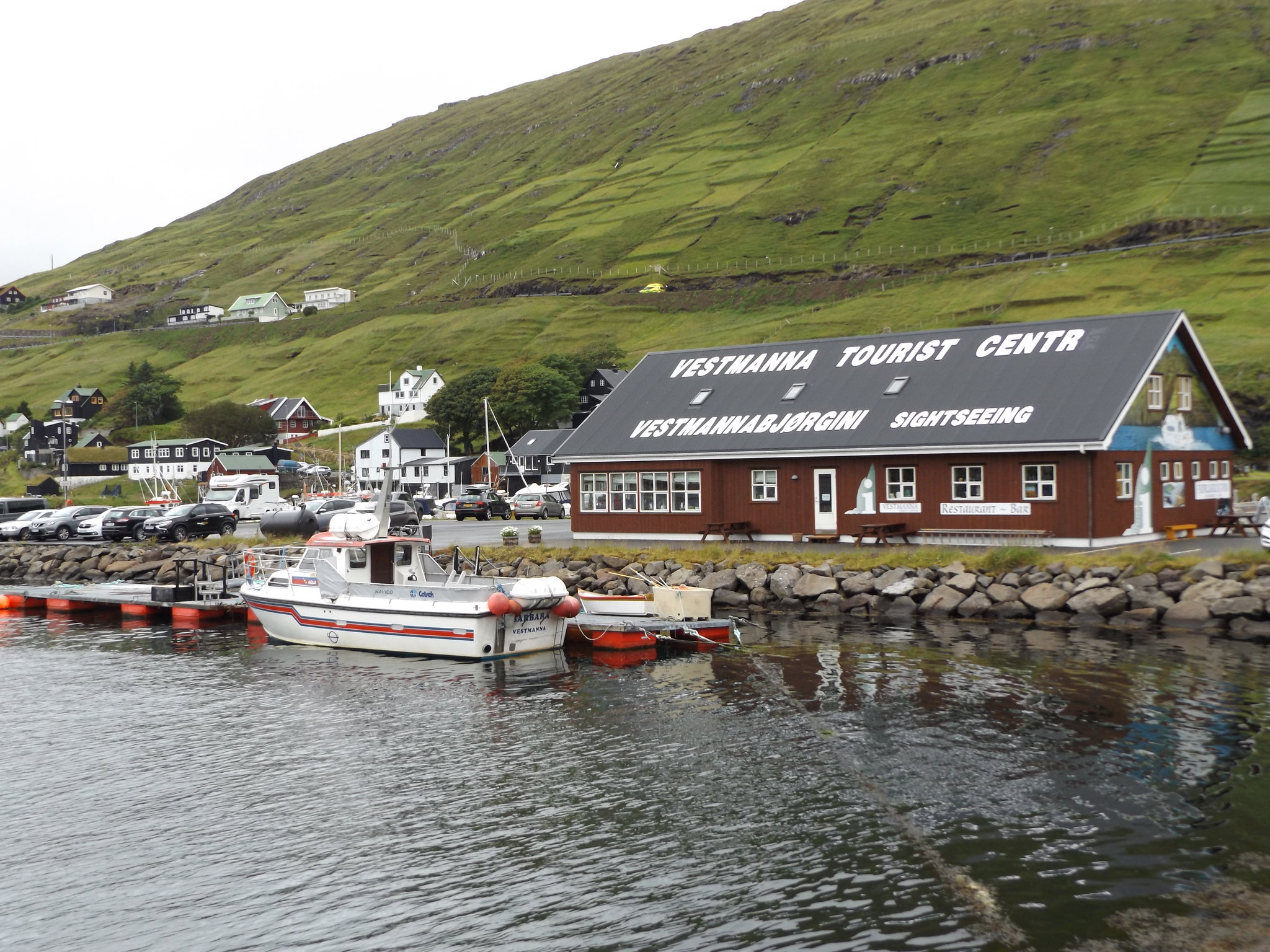
I had prebooked a boat trip to the Vestmanna bird cliffs for the Tuesday afternoon. I set off for Vestmanna in the morning in the hope of completing one of the walks in the Hiking in the Faroe Islands booklet before the boat trip. Getting to Vestmanna involved catching the airport bus (300) and changing buses at a remote petrol station in a valley west of Kollafjørður. As the bus descended into Vestmanna, there were impressive views over the town with its characteristically brightly-coloured houses straggling along the sides of a deep sea inlet. Unfortunately, it was a gloomy, drizzly morning and began to rain heavily as soon as I got off the bus near the tourist centre. It was clearly not going to be a nice day for a walk in the mountains, so I wandered around the town for a while.
The centre of the town was some distance from the tourist centre and comprised a knot of narrow, winding streets around the church, but seemed lacking in shops or other amenities. The town’s supermarket, petrol station and other facilities were on the outskirts near the tourist centre. On the hillside above the town, close to a housing development and a large school, there was an impressive waterfall which plunged into a ravine.

After exhausting the sights of the town, I returned to the tourist centre, checked in for the boat trip and had lunch in the busy restaurant. Vestmanna is one of the Faroes’ most popular destinations, and the restaurant and gift shop were crowded with Scandinavian and British tourists.
After lunch, I waited on the quayside for the boat to return from its previous trip. The weather brightened up a bit, but remained overcast. Eventually, the small boat appeared as it rounded the corner into the fjord. A large group of people had assembled on the quay and it was difficult to believe that the boat would be able to accommodate everybody. Understandably, most people wanted to sit on the outside deck and there was barely enough room for everyone to squeeze into the available seats.
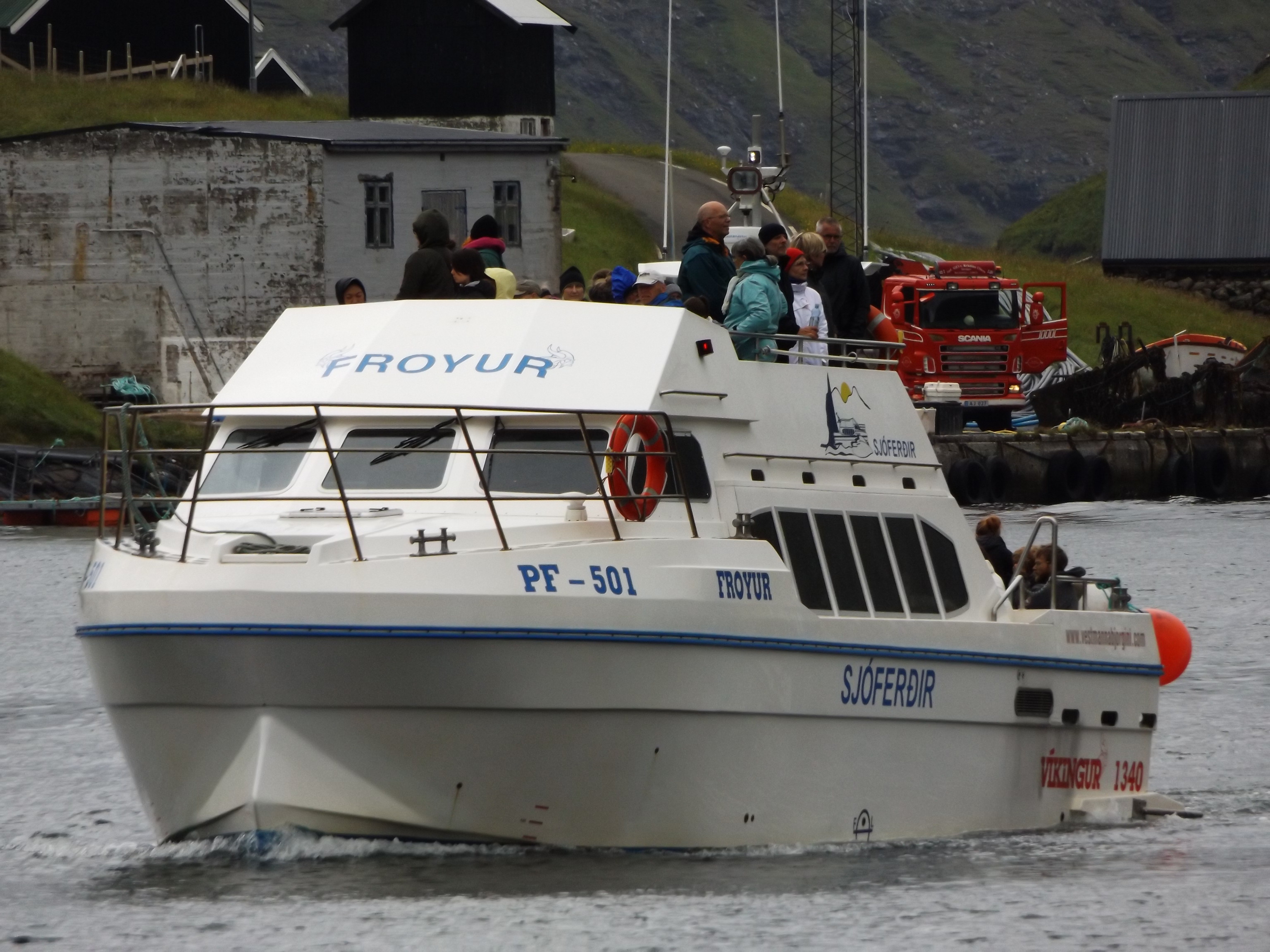
As soon as it was fully loaded, the boat set off out of Vestmanna fjord, hugging the rugged coastline, which was dotted with woolly Faroese sheep. The skipper pointed out a cluster of houses on the opposite side of the strait separating Streymoy from Vágar. With no road access, the remote village of Slættanes was abandoned in the 1960s, but some of the houses have been maintained as summer houses by the families that once lived there.
Magnificent cliffs now began to appear stretching for miles along the northwestern coast of Streymoy, punctured by caves, ravines and rock arches. We were asked to put on hard hats as the boat moved closer to the cliffs, and took us into the caves and narrow clefts enclosed by towering precipices, circling to enable all of the passengers on the crowded deck to take photographs of the stunning scenery.

What was disappointing, however, was the seabirds. Apart from the ubiquitous gulls and fulmars, there was only a rather sad-looking group of about six guillemots huddling on a high ledge. The vast throngs of auks pictured on the boat operator’s website were certainly nowhere to be seen, although the cliffs stained white with guano were evidence of large numbers of seabirds nesting in the fairly recent past. Perhaps I had come too late in the season to see large numbers of breeding seabirds, but when I visited the Shetland Islands at about the same time two years earlier, there had been plenty of seabirds to be seen at Hermaness and Sumburgh. There have been depressing reports of breeding failures at seabird colonies around the Faroes in recent years. Further north, in Iceland, which has the world’s largest puffin population, entire colonies of puffins have failed to rear a single chick. Colonies in the Shetland Islands have also experienced poor breeding seasons, while those further south in England, Wales and Ireland seem to be doing relatively well, although they are much smaller populations. Nobody is quite sure what is causing these breeding failures, but it seems likely that a change in sea currents may have diverted the huge shoals of sand-eels, on which seabirds such as puffins and kittiwakes rely to feed their young, away from their traditional routes. Climate change and industrial fishing of sand-eels may also be causing a decline in their numbers. Larger seabirds, such as gannets, which feed their young on larger fish, do not seem to be experiencing the same declines.

After a final foray into a particularly awe-inspiring ravine with an enormous sea stack at its entrance, the boat turned back towards Vestmanna, bounding rapidly across the rough sea at a distance from the cliffs.
Day 7: Gjógv
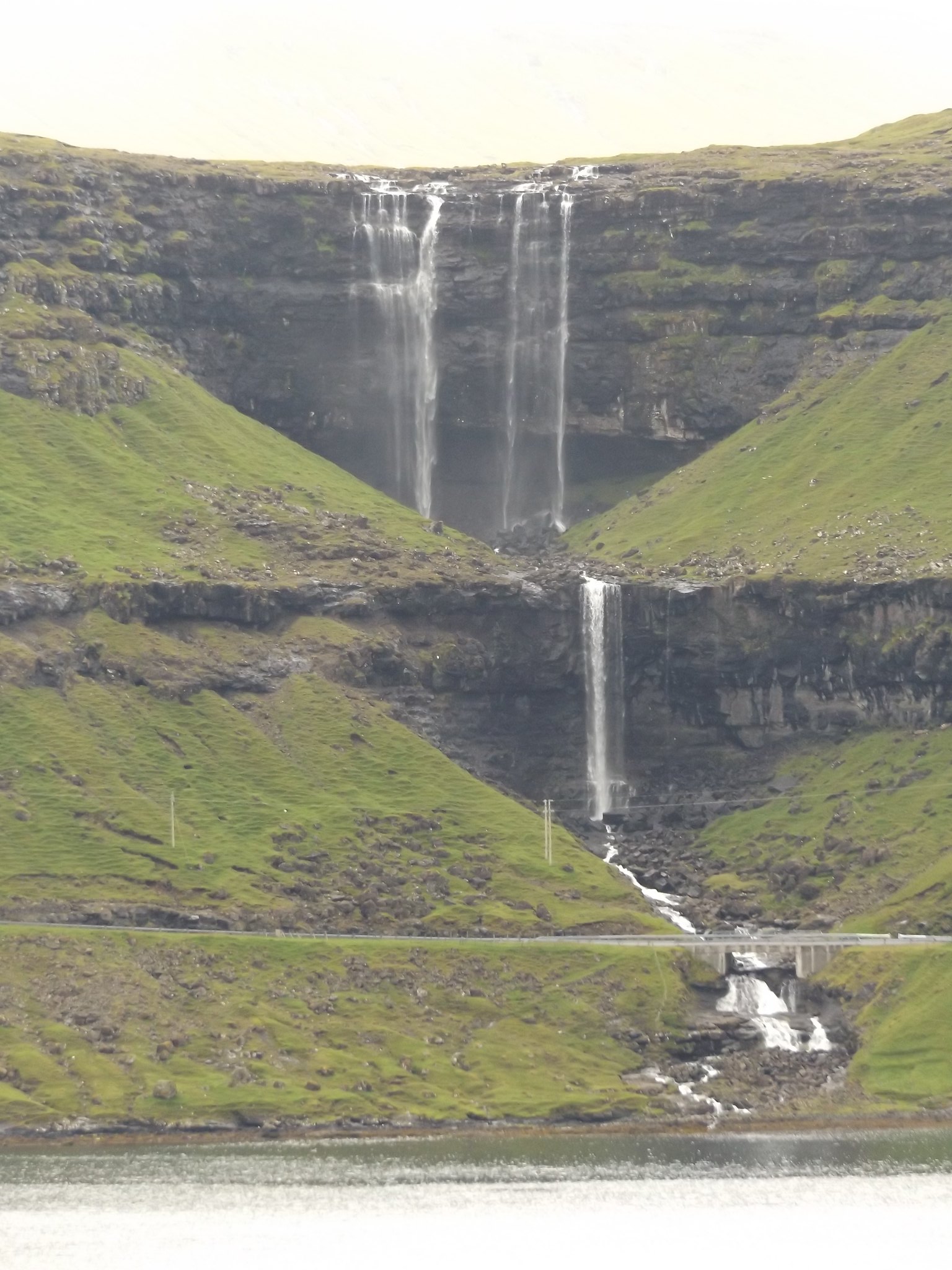
Sadly, there was no improvement in the weather for my last full day in the Faroes. I had decided to go by bus to the picturesque villages of Eiði and Gjógv at the northern end of the island of Eysturoy, and perhaps, if there was time, to scale the Faroes’ highest mountain, Slættaratindur. The bus journey involved catching the Klaksvik bus (400) along Kaldbaksfjørður and through the long tunnel to Kollafjørður for the third day running. Just after crossing the bridge over the narrow strait separating Streymoy and Eysturoy, the bus pulled into a small bus station on the outskirts of the village of Oyrarbakki, from where there was a connecting minibus to Eiði and Gjógv. As the minibus departure had been delayed by the late arrival of a connecting bus, realising that most of us were foreign tourists, the bus driver kindly stopped at the roadside north of Oyrarbakki to allow passengers to take photographs of the impressive Fossa waterfall on the other side of the strait.
I decided to continue all the way to Gjógv, the northernmost village on Eysturoy, and to walk back from there to Eiði. Gjógv is a higgledy-piggledy village of multicoloured houses nestling beside a coastal ravine (or “geo”) from which it takes its name.
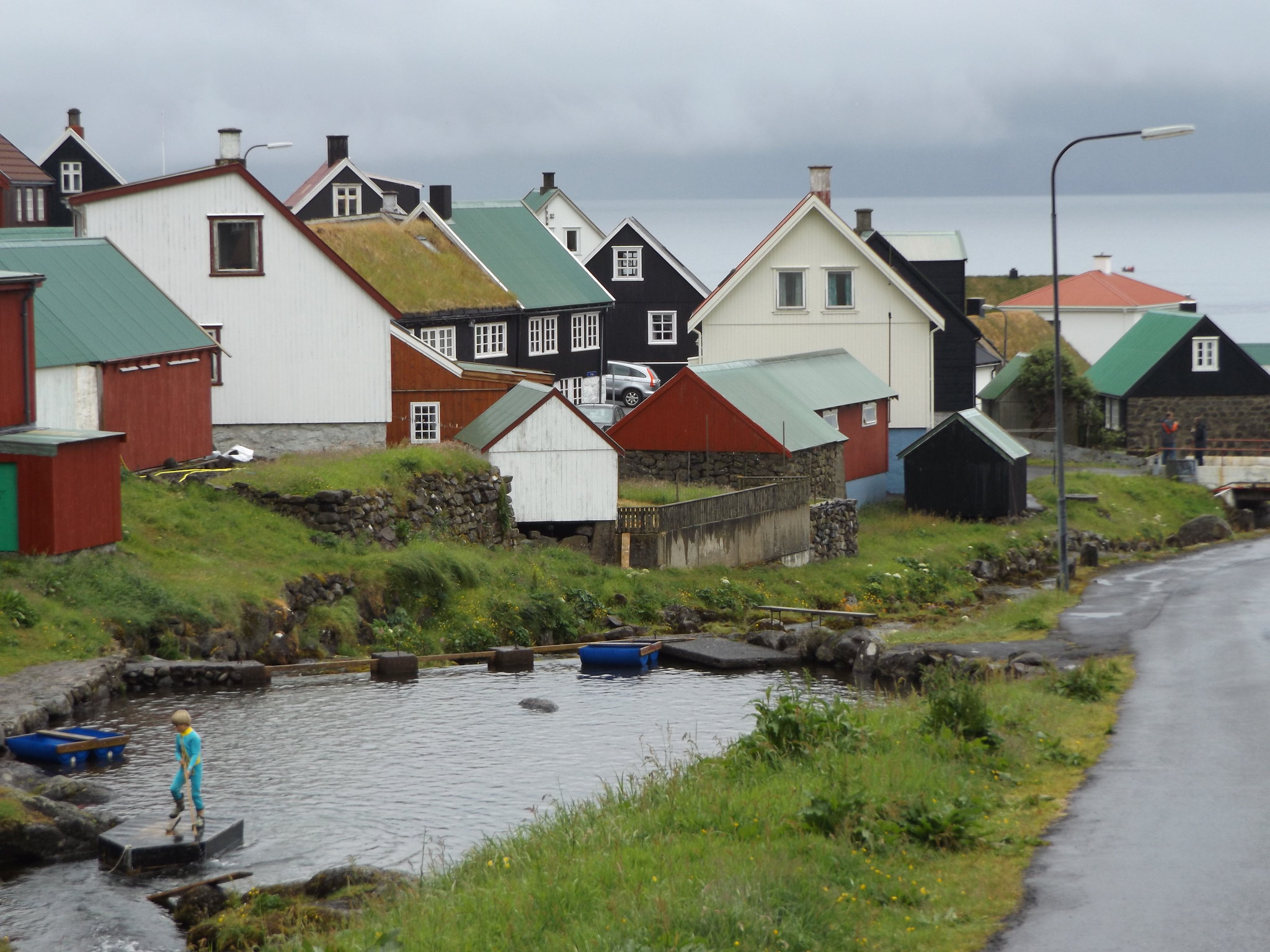
The stream running between the houses in the middle of the village has been dammed, creating a small pool which is a popular spot for children to swim and play on rafts. Gjógv is one of the Faroe Islands’ most popular visitor destinations, and on the day I visited, a tour bus full of passengers from one of the visiting cruise liners was squeezing its way through the narrow streets towards the coach park near the church, where several tour buses were already assembled. As soon as I had got off the minibus, it began to rain, so I headed straight for the shelter of the church, where one of the coach parties was listening to a talk about the importance of religion to the Faroese.
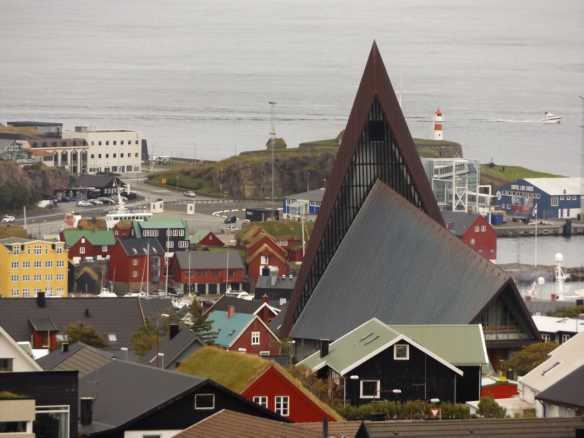
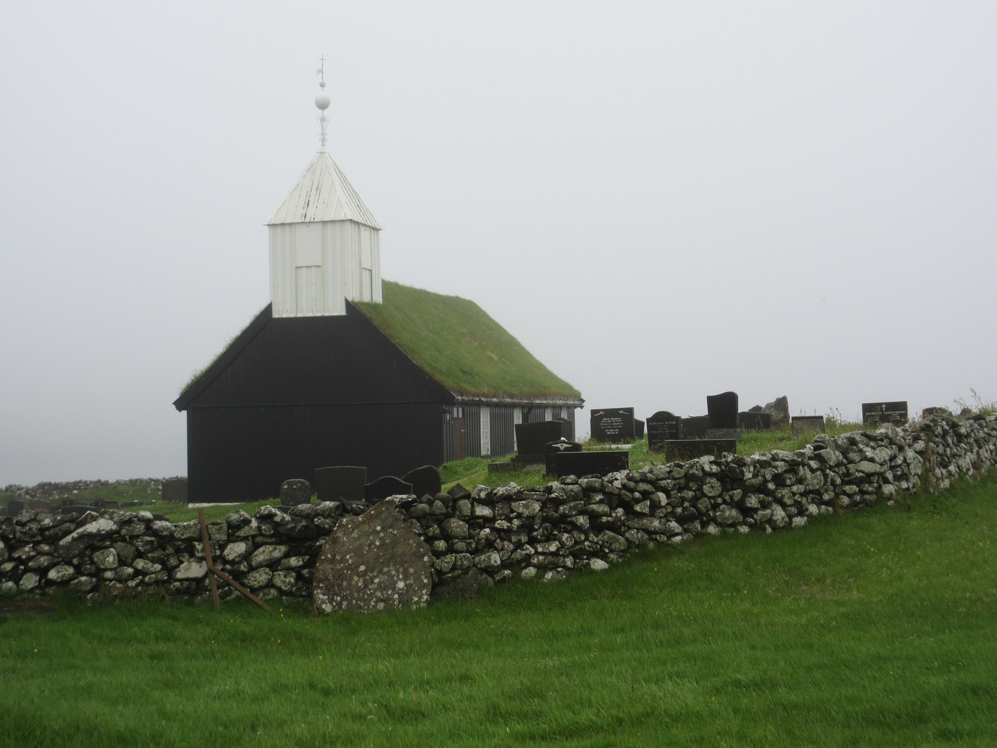
As in Iceland, there are many modern churches on the Faroe Islands, including the Vesturkirkjan with its huge, pyramid-shaped spire in Tórshavn, and the churches of Hoyvík, Toftir and Klaksvík. While Christian religious belief has declined in the UK and continental northern Europe, religion has remained very important to the Faroese. In the 2011 census, only 4% of people declared that they had no religion, compared to 26% in the UK census of the same year. Perhaps the continued importance of religion is a result of the islands’ relative isolation, a strong sense of community in which the church plays a central role, and the tough lives which Faroese people have traditionally led, with many families obtaining their livelihoods from perilous seafaring industries. Almost every village or settlement has its own church. Although the modern churches are architecturally striking, perhaps the most characteristic churches are the little black-painted wooden churches with grass roofs, like those at Kollafjørður and Funningur.
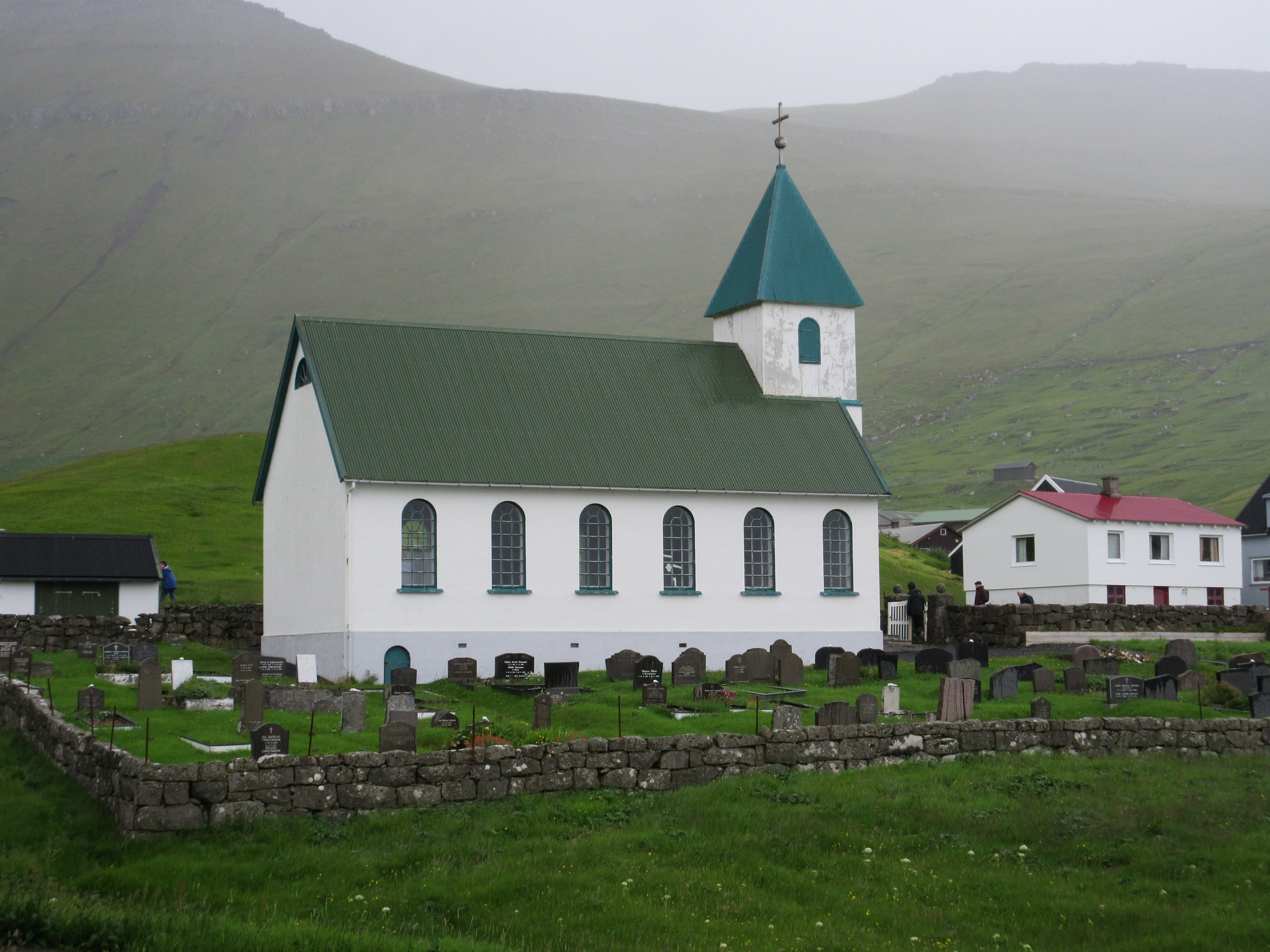
Gjógv’s church is a simple white building with a green copper roof and a square tower topped with a pyramid-shaped spire, dating from 1929. Before the church was built, the villagers had to walk to church services at Funningur, several miles away. Inside, the church was spacious, warm and welcoming on a cold, drizzly day. Outside, the church’s simple form stood out against a backdrop of dark green moorland enveloped in approaching rainclouds.
Heavy rain soon arrived, and I had to wait for a while in the village’s only bus shelter, where several other people began to congregate. Once the rain had eased off, I set off to explore the other side of the village with its impressive ravine. The ravine is used as a natural harbour for small fishing boats, and is also the focus for various outdoor pursuits, such as canoeing. Passing a large party of Danish children queuing up to go on a zip wire, I climbed the grassy path along the field overlooking the ravine, from where there was a good view over the cliffs to the village. The drizzle had now stopped completely, so I decided to brave the walk to Eiði, realising that there was absolutely nowhere to shelter on the long road if it started to rain again. It was still heavily overcast and the tops of the mountains were shrouded in fog. I started out along the road up the long mountain pass out of Gjógv, accompanied all the way by the alarm calls of whimbrels and oystercatchers.
Reaching the top of the hill, the road dropped in a couple of hairpin bends before turning to run in an almost straight line along the steep mountain side. The scenery was dramatic, with the mist-covered slopes of Slættarindur on the right and a long, narrow fjord down below on the left. Further along the hillside, I came to a road junction from where a long, switchback road led down to the village of Funningur, its cluster of houses looking like tiny dots by the shore of the fjord. Even the long ridge of mountains rising abruptly from the water on the opposite side of the fjord looked small from this high vantage point.

The road climbed higher as it turned westwards towards Eiði, passing a small car park at the start of the trail to the top of Slættaratindur. Although the summit (880 metres) could only have been about 400 metres further in altitude gain from the road, and there was a trickle of people setting out along the trail to the top, I decided to give it a miss. The path disappeared into thick cloud almost as soon as it had left the car park, and there would have been nothing to see on the climb.
Gradually, the road descended through moorland towards Eiði. For a time, the sky looked as though it might brighten up as I passed Eiðisvatn, a natural lake which has been enlarged into a reservoir to serve a hydroelectric power plant. High up on the moors flanking Slættaratindur, the distinctive bubbling call of a curlew started up, contrasting with the shorter calls of the whimbrels. Snipes drummed overhead, and just outside Eiði I was divebombed by a particularly aggressive oystercatcher.
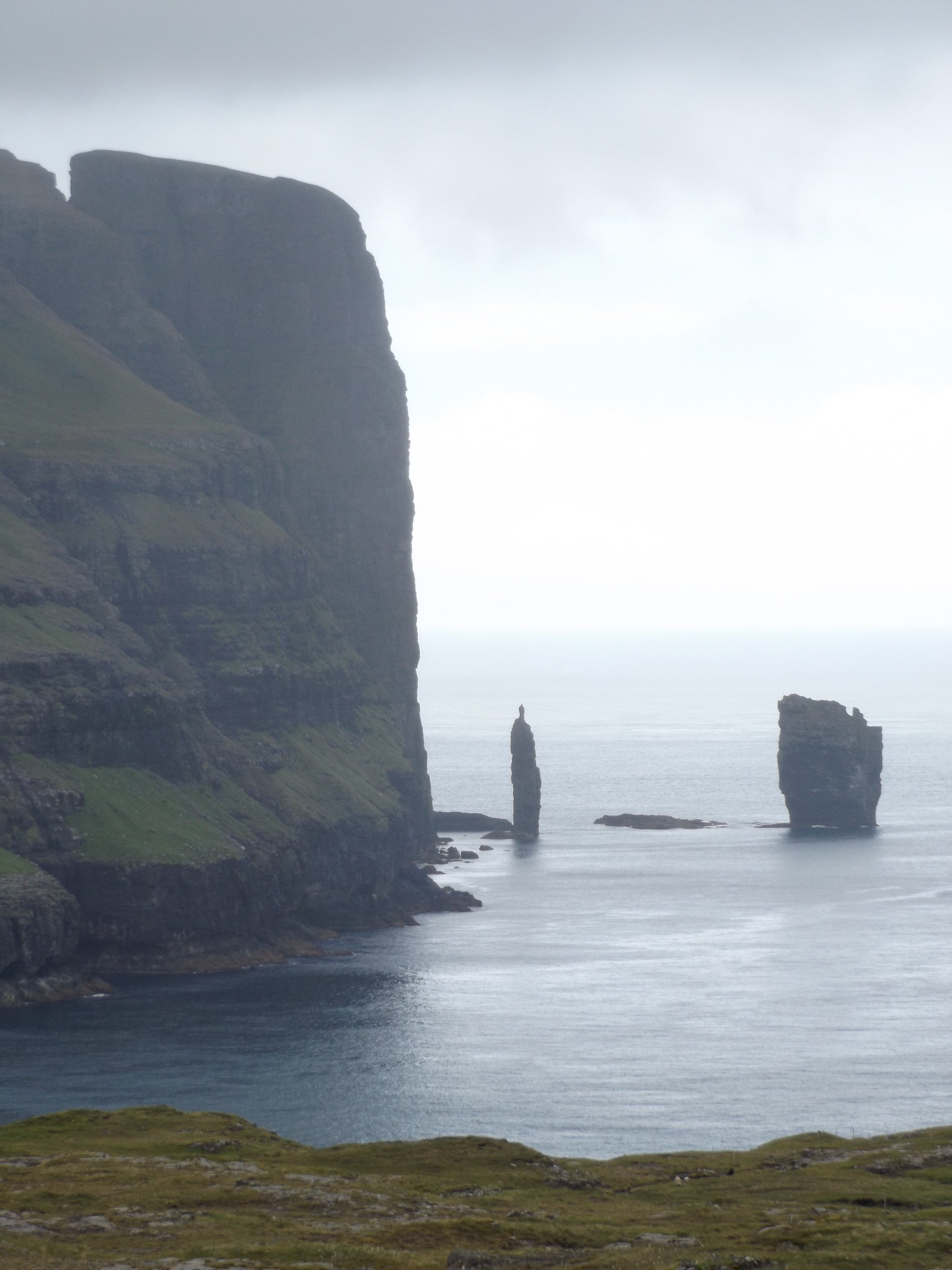
On the way into Eiði, there was a good view of one of Eysturoy’s most impressive natural sights: a pair of sea-stacks known as Risin og Kellingin (the giant and the witch) standing in front of a towering cliff. With its attractive lake and typically colourful houses, Eiði would have been an idyllic place to explore in nice weather, but unfortunately it began to rain quite heavily as I reached the village, so I spent most of the remaining time until the bus arrived sitting in the bus shelter near the church.

Day 8
On the last day, I checked out of the Guesthouse Marknagil early, in order to catch the bus to the airport. The flight departed from the tiny airport at midday. Arriving back in sunny Edinburgh in the early afternoon, I caught the tram to Haymarket, and sauntered through the city centre to while away the time until my pre-booked train from Waverley. Two trains and several hours later, I arrived back in Banbury, 15 hours after leaving Tórshavn.

1 thought on “The Faroe Islands”